
| Memorials | : | 0 |
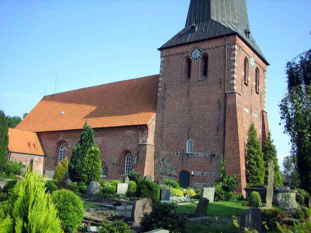
| Location | : | Sandstedt, Landkreis Cuxhaven, Germany |
| Coordinate | : | 53.3597660, 8.5246580 |
| Description | : | The first church was founded between 1043 and 1059, at the time of the Bremen archbishop Adalbert as a church of Bramstedt. From historical point of view Sandstedt has the oldest church in the country of Osterstade. Until 1419 the church was directly on the Weser River, to the north of the today's floodgate harbour. Because of progressive land demolitions on the right Weser shore the dyke had to be taken back in 1420 and a part of the village with the church be surrendered. In 1420 a brick church was established at the current place, partially from him Abbruchmaterialen of the... Read More |
frequently asked questions (FAQ):
-
Where is St. Johannis Kirche Cemetery?
St. Johannis Kirche Cemetery is located at Sandstedt, Landkreis Cuxhaven ,Lower Saxony (Niedersachsen) ,Germany.
-
St. Johannis Kirche Cemetery cemetery's updated grave count on graveviews.com?
0 memorials
-
Where are the coordinates of the St. Johannis Kirche Cemetery?
Latitude: 53.3597660
Longitude: 8.5246580
Nearby Cemetories:
1. Golzwarden
Brake (Unterweser), Landkreis Wesermarsch, Germany
Coordinate: 53.3517510, 8.4649655
2. Friedhof Brake Unterweser
Brake (Unterweser), Landkreis Wesermarsch, Germany
Coordinate: 53.3291359, 8.4730962
3. Kirchhammelwarden
Brake (Unterweser), Landkreis Wesermarsch, Germany
Coordinate: 53.3051987, 8.4862043
4. Friedhof Driftsethe
Driftsethe, Landkreis Cuxhaven, Germany
Coordinate: 53.3777100, 8.6274400
5. Kassebruch Friedhof
Hagen im Bremischen, Landkreis Cuxhaven, Germany
Coordinate: 53.3681600, 8.6486900
6. Friedhof Bramstedt
Bramstedt, Landkreis Cuxhaven, Germany
Coordinate: 53.3690200, 8.6909600
7. Bramsted Friedhof
Bramstedt, Landkreis Cuxhaven, Germany
Coordinate: 53.3693600, 8.6909300
8. Friedhof Esenshamm
Nordenham, Landkreis Wesermarsch, Germany
Coordinate: 53.4493784, 8.4400323
9. Kirchhof der St. Marien-Kirch
Oldenburg, Stadtkreis Oldenburg, Germany
Coordinate: 53.4020000, 8.3567240
10. Friedhof Hollen
Hollen, Landkreis Cuxhaven, Germany
Coordinate: 53.4250069, 8.7132196
11. Friedhof Garlstedt
Osterholz-Scharmbeck, Landkreis Osterholz, Germany
Coordinate: 53.2841986, 8.7051486
12. Friedhof Rekum
Bremen, Stadtgemeinde Bremen, Germany
Coordinate: 53.2270360, 8.5118620
13. Friedhof Abbehausen
Nordenham, Landkreis Wesermarsch, Germany
Coordinate: 53.4837677, 8.4354812
14. Friedhof Atens
Nordenham, Landkreis Wesermarsch, Germany
Coordinate: 53.4959464, 8.4733267
15. Friedhof Bremerhaven-Alt Wulsdorf
Bremerhaven, Stadt Bremerhaven, Germany
Coordinate: 53.5026207, 8.5970344
16. Friedhof Bokel
Bokel (Bersenbruck), Landkreis Osnabrück, Germany
Coordinate: 53.3937068, 8.7713954
17. Waldfriedhof Bremen-Blumenthal
Bremen, Stadtgemeinde Bremen, Germany
Coordinate: 53.2028450, 8.5622120
18. Friedhof Bremerhaven-Wulsdorf
Bremerhaven, Stadt Bremerhaven, Germany
Coordinate: 53.5134720, 8.5965280
19. Katholischer Friedhof Bremen-Blumenthal
Bremen, Stadtgemeinde Bremen, Germany
Coordinate: 53.2015560, 8.5630830
20. Friedhof Rönnebeck-Farge
Bremen, Stadtgemeinde Bremen, Germany
Coordinate: 53.1949387, 8.5336523
21. Lutherischer Friedhof Bremen-Blumenthal
Bremen, Stadtgemeinde Bremen, Germany
Coordinate: 53.1940070, 8.5797900
22. Friedhof Blexen
Nordenham, Landkreis Wesermarsch, Germany
Coordinate: 53.5319838, 8.5369164
23. St. Marien in Berne-Warfleth
Warfleth, Landkreis Wesermarsch, Germany
Coordinate: 53.1859001, 8.5252065
24. Geestemünder Friedhof
Geestemünde, Stadt Bremerhaven, Germany
Coordinate: 53.5277600, 8.6047800