
| Memorials | : | 2 |
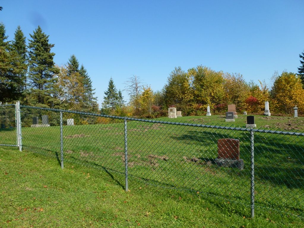
| Location | : | Aylwin, Outaouais Region, Canada |
| Coordinate | : | 46.0013100, -76.0408600 |
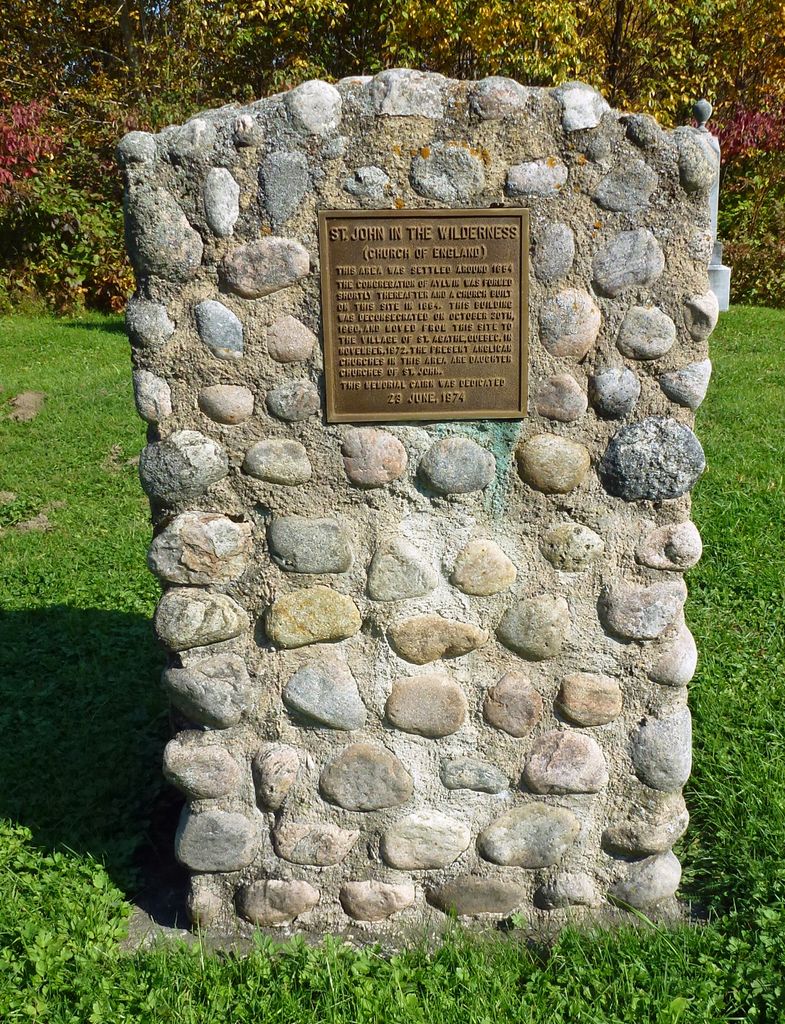
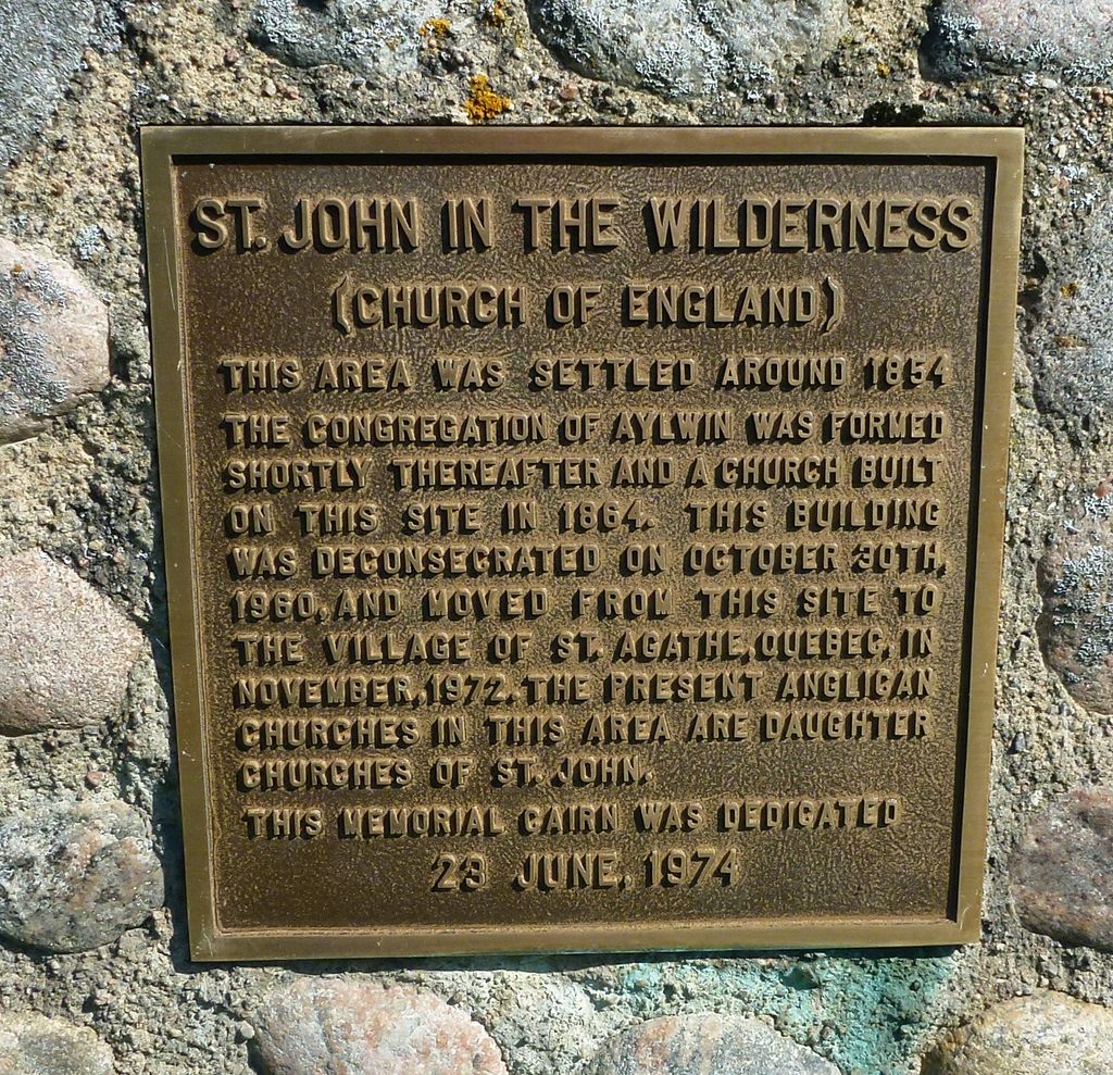
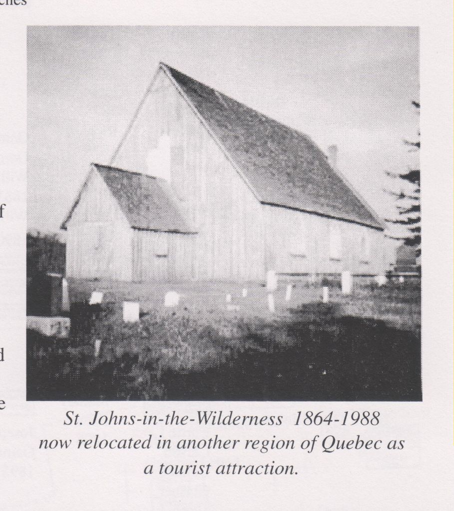
| Description | : | In 1863, the Rev. Francis Codd visited Aylwin township and held services there. The following year, the Mission of Wakefield and Aylwin was created. This mission was then divided in 1866; the mission of Aylwin was the northern half extending to the Hudson's Bay Post 100 miles north of Ottawa. St. John's in the Wilderness, Aylwin was consecrated in 1873. The mission became part of the parish of River Desert in 1919, the name of the parish changing to Aylwin in 1921. On October 1, 1960, Bishop John Dixon of Montreal deconsecrated St. John's in the Wilderness and in 1972... Read More |
frequently asked questions (FAQ):
-
Where is St. John's in the Wilderness Anglican Cemetery?
St. John's in the Wilderness Anglican Cemetery is located at Aylwin, Outaouais Region ,Quebec ,Canada.
-
St. John's in the Wilderness Anglican Cemetery cemetery's updated grave count on graveviews.com?
2 memorials
-
Where are the coordinates of the St. John's in the Wilderness Anglican Cemetery?
Latitude: 46.0013100
Longitude: -76.0408600
Nearby Cemetories:
1. Hillcrest Cemetery
Aylwin, Outaouais Region, Canada
Coordinate: 45.9962200, -76.0415500
2. St. Andrews United Church Cemetery
Aylwin, Outaouais Region, Canada
Coordinate: 45.9899700, -76.0267400
3. Pineridge Cemetery
Kazabazua, Outaouais Region, Canada
Coordinate: 45.9511800, -76.0361900
4. Mont Carmel Cemetery
Kazabazua, Outaouais Region, Canada
Coordinate: 45.9527060, -76.0220680
5. Campbell's Cemetery
McBean, Outaouais Region, Canada
Coordinate: 46.0514000, -76.0087300
6. Saint Stephen's Church Cemetery
Kazabazua, Outaouais Region, Canada
Coordinate: 45.9484000, -76.0156700
7. Trinity United Church Cemetery
Kazabazua, Outaouais Region, Canada
Coordinate: 45.9473610, -76.0127220
8. Saint James Anglican Church Cemetery
Gracefield, Outaouais Region, Canada
Coordinate: 46.0812350, -76.0593070
9. Cimitière Saint-Nom-de-Marie
Lac-Sainte-Marie, Outaouais Region, Canada
Coordinate: 45.9469495, -75.9526693
10. Draper Cemetery
McBean, Outaouais Region, Canada
Coordinate: 46.0784100, -75.9790700
11. Old Gracefield Cemetery
Gracefield, Outaouais Region, Canada
Coordinate: 46.0912520, -76.0507520
12. Gracefield New Cemetery
Gracefield, Outaouais Region, Canada
Coordinate: 46.1009760, -76.0466130
13. Holy Trinity Anglican Cemetery
Danford Lake, Outaouais Region, Canada
Coordinate: 45.9253190, -76.1574410
14. Danford Lake Methodist / United Cemetery
Danford Lake, Outaouais Region, Canada
Coordinate: 45.9236020, -76.1610820
15. Pointe-Comfort
Pointe-Comfort, Outaouais Region, Canada
Coordinate: 46.0858920, -75.8461540
16. Northfield United Church Cemetery
Gracefield, Outaouais Region, Canada
Coordinate: 46.1519380, -75.9465900
17. Saint Martin's Cemetery
Martindale, Outaouais Region, Canada
Coordinate: 45.8383510, -75.9449480
18. Martindale Irish Pioneer Cemetery
Martindale, Outaouais Region, Canada
Coordinate: 45.8363080, -75.9451530
19. Holy Cross Cemetery
Fieldville, Outaouais Region, Canada
Coordinate: 45.8123260, -76.0249300
20. Blue Sea Lake R.C. Cemetery
Blue Sea, Outaouais Region, Canada
Coordinate: 46.1907900, -76.0687400
21. United Church Cemetery
Low, Outaouais Region, Canada
Coordinate: 45.8161200, -75.9476900
22. Saint Roch Cemetery
Cayamant, Outaouais Region, Canada
Coordinate: 46.1380800, -76.2481900
23. Saint Gabriel Cemetery
Bouchette, Outaouais Region, Canada
Coordinate: 46.1990920, -75.9690680
24. St. Peter's Anglican Church Cemetery
Cawood, Outaouais Region, Canada
Coordinate: 45.8292410, -76.1991450