
| Memorials | : | 0 |
| Location | : | Würzburg, Stadtkreis Würzburg, Germany |
| Coordinate | : | 49.7933780, 9.9323970 |
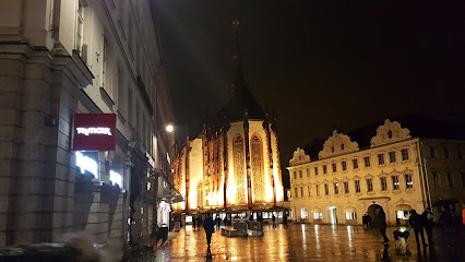
| Description | : | Both the first church on the site, built in 787, and the second, built in 855, were destroyed by fire. The present cathedral was begun in 1040, finished 1075, rebuilt several more times, and finally consecrated in 1187. That church already had the strong cross lay-out still present today: a long nave with a high choir, the broad transept and the two narrow western towers. Remodelling continued periodically until the building collapsed in the fire bombing of Würzburg in 1946. Reconstruction, finished in 1967, replaced Baroque components with Romanesque. With a length of 103 metres, the cathedral is the fourth... Read More |
frequently asked questions (FAQ):
-
Where is St.-Kilians-Dom zu Würzburg?
St.-Kilians-Dom zu Würzburg is located at Würzburg, Stadtkreis Würzburg ,Bavaria (Bayern) ,Germany.
-
St.-Kilians-Dom zu Würzburg cemetery's updated grave count on graveviews.com?
0 memorials
-
Where are the coordinates of the St.-Kilians-Dom zu Würzburg?
Latitude: 49.7933780
Longitude: 9.9323970
Nearby Cemetories:
1. Marienkapelle
Würzburg, Stadtkreis Würzburg, Germany
Coordinate: 49.7947780, 9.9295830
2. Bürgerspital zum Heiligen Geist
Würzburg, Stadtkreis Würzburg, Germany
Coordinate: 49.7962260, 9.9352420
3. Hauptfriedhof Würzburg
Würzburg, Stadtkreis Würzburg, Germany
Coordinate: 49.7968270, 9.9469590
4. Kirche Johannes der Evangelist
Würzburg, Stadtkreis Würzburg, Germany
Coordinate: 49.7833330, 9.9333330
5. Friedhof Würzburg-Unterdürrbach
Unterdürrbach, Stadtkreis Würzburg, Germany
Coordinate: 49.8129946, 9.9186926
6. Jüdischer Friedhof Würzburg
Würzburg, Stadtkreis Würzburg, Germany
Coordinate: 49.7970610, 9.9782550
7. Waldfriedhof Würzburg
Würzburg, Stadtkreis Würzburg, Germany
Coordinate: 49.7641980, 9.9187760
8. Jüdischer Friedhof Würzburg-Heidingsfeld
Heidingsfeld, Stadtkreis Würzburg, Germany
Coordinate: 49.7634171, 9.9430184
9. Friedhof Würzburg-Versbach
Versbach, Stadtkreis Würzburg, Germany
Coordinate: 49.8181149, 9.9619048
10. Friedhof Würzburg-Oberdürrbach
Oberdürrbach, Stadtkreis Würzburg, Germany
Coordinate: 49.8243529, 9.9256462
11. Friedhof Würzburg-Heidingsfeld
Heidingsfeld, Stadtkreis Würzburg, Germany
Coordinate: 49.7620549, 9.9548257
12. Alter Friedhof Gerbrunn
Gerbrunn, Landkreis Würzburg, Germany
Coordinate: 49.7806772, 9.9844847
13. Jüdischer Friedhof Höchberg
Höchberg, Landkreis Würzburg, Germany
Coordinate: 49.7775214, 9.8776501
14. Alter Friedhof Höchberg
Höchberg, Landkreis Würzburg, Germany
Coordinate: 49.7817970, 9.8734680
15. Neuer Friedhof Gerbrunn
Gerbrunn, Landkreis Würzburg, Germany
Coordinate: 49.7793716, 9.9927826
16. Friedhof Randersacker
Randersacker, Landkreis Würzburg, Germany
Coordinate: 49.7613912, 9.9800217
17. Neuer Friedhof Höchberg
Höchberg, Landkreis Würzburg, Germany
Coordinate: 49.7799125, 9.8656097
18. Neuer Friedhof Veitshöchheim
Veitshöchheim, Landkreis Würzburg, Germany
Coordinate: 49.8346946, 9.8996030
19. Waldfriedhof Waldbüttelbrunn
Waldbüttelbrunn, Landkreis Würzburg, Germany
Coordinate: 49.7880324, 9.8529867
20. Alter Friedhof Veitshöchheim
Veitshöchheim, Landkreis Würzburg, Germany
Coordinate: 49.8365490, 9.8751661
21. Neuer Friedhof Margetshöchheim
Margetshöchheim, Landkreis Würzburg, Germany
Coordinate: 49.8300008, 9.8643499
22. Friedhof Rottendorf
Rottendorf, Landkreis Würzburg, Germany
Coordinate: 49.7962819, 10.0258960
23. Alter Friedhof Estenfeld
Estenfeld, Landkreis Würzburg, Germany
Coordinate: 49.8315980, 10.0073106
24. Friedhof Rimpar
Rimpar, Landkreis Würzburg, Germany
Coordinate: 49.8542417, 9.9561946