
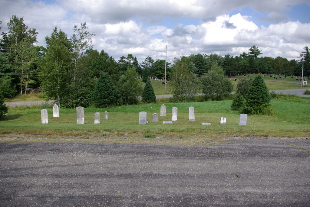
| Memorials | : | 12 |
| Location | : | Middle New Cornwall, Lunenburg County, Canada |
| Coordinate | : | 44.5033550, -64.5245290 |
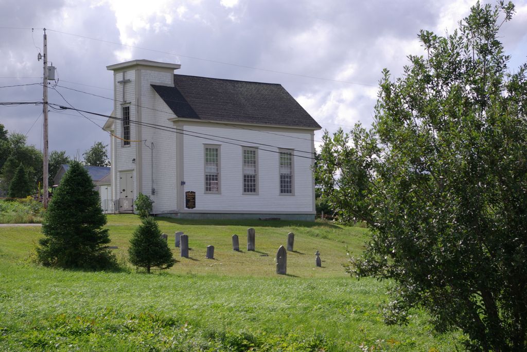
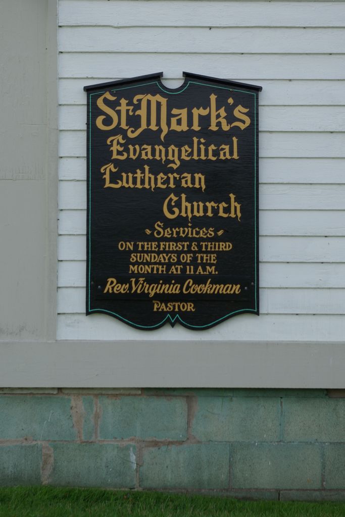
| Description | : | Middle New Cornwall is a small rural community in Lunenburg County, Nova Scotia. It is about 23 kilometers north-west of Lunenburg. Saint Mark's Evangelical Lutheran Church, built in 1863, was designated a Canada Historic Place in 2003, listed on the Canadian Register in 2006. The register entry of Canadian Historic Places WWW site for the church is: < http://www.historicplaces.ca/en/rep-reg/place-lieu.aspx?id=5751 > Road address is: 1231 Back Cornwall Road, Middle New Cornwall, Nova Scotia, Canada. Map Grid location is: N 44.503423, W 64.524616. Access by road from Lunenburg is easy: simply take Northwest Road (Hwy 324) out of Lunenburg and follow the road (crossing Hwy 103 at Blockhouse)... Read More |
frequently asked questions (FAQ):
-
Where is St Mark's Evangelical Lutheran Church Cemetery?
St Mark's Evangelical Lutheran Church Cemetery is located at Middle New Cornwall, Lunenburg County ,Nova Scotia ,Canada.
-
St Mark's Evangelical Lutheran Church Cemetery cemetery's updated grave count on graveviews.com?
12 memorials
-
Where are the coordinates of the St Mark's Evangelical Lutheran Church Cemetery?
Latitude: 44.5033550
Longitude: -64.5245290
Nearby Cemetories:
1. Middle New Cornwall Memorial Gardens
Middle New Cornwall, Lunenburg County, Canada
Coordinate: 44.5038300, -64.5231670
2. Lower Cornwall Graveyard
Lower New Cornwall, Lunenburg County, Canada
Coordinate: 44.4912230, -64.4846840
3. Old French Cemetery
Lunenburg, Lunenburg County, Canada
Coordinate: 44.5372220, -64.5413880
4. Sweetland Cemetery
Sweetland, Lunenburg County, Canada
Coordinate: 44.4682400, -64.5079200
5. Farmville Cemetery
Farmville, Lunenburg County, Canada
Coordinate: 44.4649900, -64.4690100
6. Christ Anglican Church Cemetery
Maitland, Lunenburg County, Canada
Coordinate: 44.4312900, -64.4799300
7. Pinehurst Community
Pinehurst, Lunenburg County, Canada
Coordinate: 44.4965560, -64.6441110
8. Union Square Cemetery
Union Square, Lunenburg County, Canada
Coordinate: 44.5514040, -64.6276790
9. Blockhouse Cemetery
Blockhouse, Lunenburg County, Canada
Coordinate: 44.4479400, -64.4228800
10. Hillside Cemetery
Branch LaHave, Lunenburg County, Canada
Coordinate: 44.4495700, -64.6314500
11. Saint James Lutheran Cemetery
Branch LaHave, Lunenburg County, Canada
Coordinate: 44.4560000, -64.6380100
12. Garden of Rest Cemetery
Blockhouse, Lunenburg County, Canada
Coordinate: 44.4468900, -64.4110800
13. Clearland Hillside Cemetery
Clearland, Lunenburg County, Canada
Coordinate: 44.4646000, -64.3949030
14. Saint Matthew's Lutheran Cemetery
Newburne, Lunenburg County, Canada
Coordinate: 44.5957700, -64.5967800
15. Newburne Cemetery (Old)
Newburne, Lunenburg County, Canada
Coordinate: 44.5957690, -64.5970560
16. Saint Matthew's Catholic Cemetery
Elmwood, Lunenburg County, Canada
Coordinate: 44.5802800, -64.6277300
17. Park Cemetery
Mahone Bay, Lunenburg County, Canada
Coordinate: 44.4465300, -64.3892400
18. Midville Branch Cemetery
Midville Branch, Lunenburg County, Canada
Coordinate: 44.4215800, -64.6320500
19. Bayview Cemetery
Mahone Bay, Lunenburg County, Canada
Coordinate: 44.4537700, -64.3819700
20. Lakeside Cemetery
New Canada, Lunenburg County, Canada
Coordinate: 44.4851500, -64.6890600
21. Brookside Cemetery
Bridgewater, Lunenburg County, Canada
Coordinate: 44.3819400, -64.5285800
22. Saint Joseph's Catholic Cemetery
Bridgewater, Lunenburg County, Canada
Coordinate: 44.3785600, -64.5303900
23. Barss Corner Community Cemetery
Barss Corner, Lunenburg County, Canada
Coordinate: 44.5650711, -64.6792679
24. Barss Corner Baptist Cemetery
Barss Corner, Lunenburg County, Canada
Coordinate: 44.5700200, -64.6815800