
| Memorials | : | 1 |
| Location | : | Nedging, Babergh District, England |
| Phone | : | 01449740085 |
| Coordinate | : | 52.0961240, 0.9162650 |
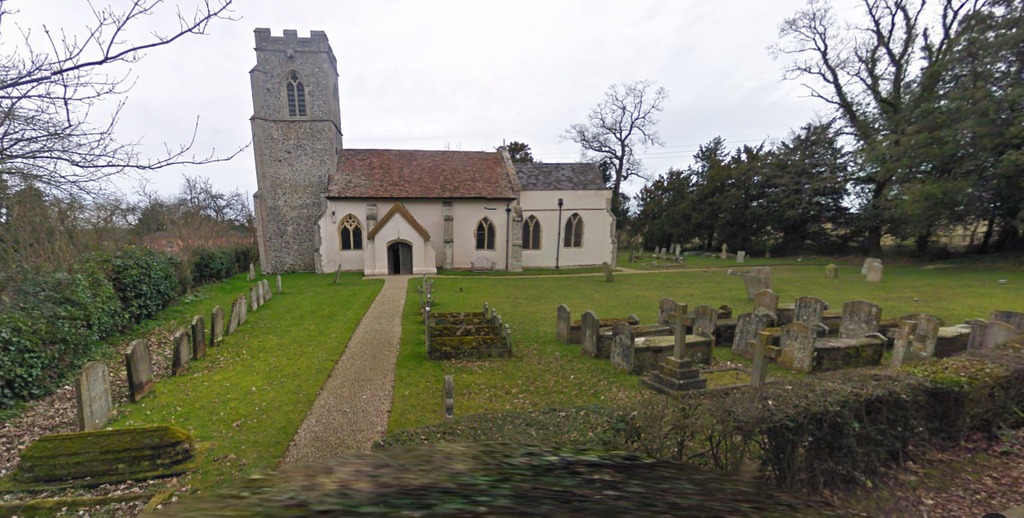
| Description | : | St Mary Churchyard is a peaceful plot surrounding the 12th-cent. church in a rural hamlet and is rather hard to find. Turn off the B1115 about half a mile south of Bildeston, go up the steep hill of Nedging road, and turn right at the top at the entrance to Nedging Hall Manor. The churchyard is on your right. The church is open most all the time, and people are free to wander all about the place. |
frequently asked questions (FAQ):
-
Where is St Mary Churchyard?
St Mary Churchyard is located at Nedging Road Nedging, Babergh District ,Suffolk , IP7 7England.
-
St Mary Churchyard cemetery's updated grave count on graveviews.com?
1 memorials
-
Where are the coordinates of the St Mary Churchyard?
Latitude: 52.0961240
Longitude: 0.9162650


Nearby Cemetories:
1. All Saints Churchyard
Semer, Babergh District, England
Coordinate: 52.0833230, 0.9161770
2. St Mary Magdelene
Bildeston, Babergh District, England
Coordinate: 52.1056020, 0.8982980
3. All Saints Churchyard
Chelsworth, Babergh District, England
Coordinate: 52.0941820, 0.8896270
4. St. Mary's Churchyard
Naughton, Babergh District, England
Coordinate: 52.1019900, 0.9519300
5. St. Margaret's Churchyard
Whatfield, Babergh District, England
Coordinate: 52.0809720, 0.9541610
6. All Saints Churchyard
Hitcham, Babergh District, England
Coordinate: 52.1226340, 0.8974440
7. Saint Peter's Churchyard
Monks Eleigh, Babergh District, England
Coordinate: 52.0930860, 0.8688960
8. St Nicholas Churchyard
Wattisham, Babergh District, England
Coordinate: 52.1241910, 0.9344540
9. Monks Eleigh United Reformed Church
Monks Eleigh, Babergh District, England
Coordinate: 52.0918390, 0.8673530
10. St Mary Churchyard
Kettlebaston, Babergh District, England
Coordinate: 52.1158580, 0.8698780
11. St Peter's Churchyard
Lindsey, Babergh District, England
Coordinate: 52.0672960, 0.8842620
12. Wattisham Baptist Chapelyard
Wattisham, Babergh District, England
Coordinate: 52.1295550, 0.9353850
13. St. Mary's Churchyard
Kersey, Babergh District, England
Coordinate: 52.0574611, 0.9190082
14. St Peter's Churchyard
Milden, Babergh District, England
Coordinate: 52.0824970, 0.8569200
15. St. Mary & St. Lawrence Churchyard
Great Bricett, Mid Suffolk District, England
Coordinate: 52.1167140, 0.9762430
16. St Mary Churchyard
Brent Eleigh, Babergh District, England
Coordinate: 52.0983910, 0.8341560
17. St Mary's Churchyard
Preston St Mary, Babergh District, England
Coordinate: 52.1166280, 0.8410180
18. St. Mary's Churchyard
Aldham, Babergh District, England
Coordinate: 52.0604960, 0.9756480
19. Friars Road Cemetery
Hadleigh, Babergh District, England
Coordinate: 52.0481800, 0.9453100
20. St. Peter's Churchyard
Elmsett, Babergh District, England
Coordinate: 52.0849030, 1.0036590
21. St. Mary's Churchyard
Hadleigh, Babergh District, England
Coordinate: 52.0436290, 0.9526880
22. Hadleigh Baptist Churchyard
Hadleigh, Babergh District, England
Coordinate: 52.0444510, 0.9562658
23. St. Catherine's Churchyard
Ringshall, Mid Suffolk District, England
Coordinate: 52.1365910, 0.9840370
24. Hadleigh United Reformed Churchyard
Hadleigh, Babergh District, England
Coordinate: 52.0426790, 0.9533380