
| Memorials | : | 0 |
| Location | : | Bollschweil, Landkreis Breisgau-Hochschwarzwald, Germany |
| Coordinate | : | 47.9080560, 7.8375000 |
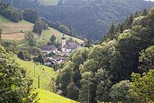
| Description | : | St. Ulrich's Priory in the Black Forest was a priory of Cluny Abbey founded in the valley of the River Möhlin in the Black Forest in about 1083. St. Ulrich is now part of the municipality of Bollschweil, in the district of Breisgau-Hochschwarzwald, Baden-Württemberg, Germany. |
frequently asked questions (FAQ):
-
Where is St. Ulrich's Priory in the Black Forest?
St. Ulrich's Priory in the Black Forest is located at Bollschweil, Landkreis Breisgau-Hochschwarzwald ,Baden-Württemberg , 79283Germany.
-
St. Ulrich's Priory in the Black Forest cemetery's updated grave count on graveviews.com?
0 memorials
-
Where are the coordinates of the St. Ulrich's Priory in the Black Forest?
Latitude: 47.9080560
Longitude: 7.8375000
Nearby Cemetories:
1. Ruhewald Wittnau
Wittnau, Landkreis Breisgau-Hochschwarzwald, Germany
Coordinate: 47.9375038, 7.8279565
2. Friedhof Bollschweil
Bollschweil, Landkreis Breisgau-Hochschwarzwald, Germany
Coordinate: 47.9235493, 7.7864451
3. Friedhof Hofsgrund
Oberried, Landkreis Breisgau-Hochschwarzwald, Germany
Coordinate: 47.9025840, 7.8978140
4. Wittnauer Friedhof
Wittnau, Landkreis Breisgau-Hochschwarzwald, Germany
Coordinate: 47.9471093, 7.8141889
5. Friedhof Münstertal
Münstertal, Landkreis Breisgau-Hochschwarzwald, Germany
Coordinate: 47.8646755, 7.8021900
6. Friedhof Günterstal
Freiburg im Breisgau, Stadtkreis Freiburg im Breisgau, Germany
Coordinate: 47.9657530, 7.8563900
7. Friedhof Ehrenstetten
Ehrenstetten, Landkreis Breisgau-Hochschwarzwald, Germany
Coordinate: 47.9110541, 7.7490930
8. Friedhof Merzhausen
Merzhausen, Landkreis Breisgau-Hochschwarzwald, Germany
Coordinate: 47.9668483, 7.8251923
9. Friedhof Wolfenweiler
Wolfenweiler, Landkreis Breisgau-Hochschwarzwald, Germany
Coordinate: 47.9620320, 7.7648763
10. Friedhof Kappel
Freiburg im Breisgau, Stadtkreis Freiburg im Breisgau, Germany
Coordinate: 47.9663000, 7.9085324
11. Friedhof Staufen im Breisgau
Staufen im Breisgau, Landkreis Breisgau-Hochschwarzwald, Germany
Coordinate: 47.8816360, 7.7281730
12. Friedhof St. Georgen
Freiburg im Breisgau, Stadtkreis Freiburg im Breisgau, Germany
Coordinate: 47.9817100, 7.7914900
13. Friedhof Bergäcker
Freiburg im Breisgau, Stadtkreis Freiburg im Breisgau, Germany
Coordinate: 47.9816410, 7.8874970
14. Friedhof Oberried
Oberried, Landkreis Breisgau-Hochschwarzwald, Germany
Coordinate: 47.9339239, 7.9536464
15. Friedhof Haslach
Freiburg im Breisgau, Stadtkreis Freiburg im Breisgau, Germany
Coordinate: 47.9897949, 7.8158510
16. Friedhof Alt-Littenweiler
Freiburg im Breisgau, Stadtkreis Freiburg im Breisgau, Germany
Coordinate: 47.9814940, 7.8994817
17. Friedhof Todtnauberg
Todtnauberg, Landkreis Lörrach, Germany
Coordinate: 47.8504569, 7.9433218
18. Friedhof Bad Krozingen
Bad Krozingen, Landkreis Breisgau-Hochschwarzwald, Germany
Coordinate: 47.9118243, 7.7010780
19. Friedhof Ebnet
Ebnet, Stadtkreis Freiburg im Breisgau, Germany
Coordinate: 47.9885768, 7.9046790
20. Alter Friedhof Freiburg im Breisgau
Freiburg im Breisgau, Stadtkreis Freiburg im Breisgau, Germany
Coordinate: 48.0007410, 7.8569630
21. Alter Friedhof Kirchzarten
Kirchzarten, Landkreis Breisgau-Hochschwarzwald, Germany
Coordinate: 47.9666670, 7.9500000
22. Ruheberg Oberried
Oberried, Landkreis Breisgau-Hochschwarzwald, Germany
Coordinate: 47.9085046, 7.9819027
23. Hauptfriedhof Freiburg
Freiburg im Breisgau, Stadtkreis Freiburg im Breisgau, Germany
Coordinate: 48.0073400, 7.8451400
24. Friedhof am Giersberg
Kirchzarten, Landkreis Breisgau-Hochschwarzwald, Germany
Coordinate: 47.9600654, 7.9645197