
| Memorials | : | 0 |
| Location | : | Wesel, Kreis Wesel, Germany |
| Coordinate | : | 51.6559000, 6.6129530 |
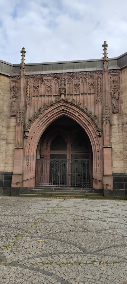
| Description | : | When the Carthusians monastery Regina Coeli on the Grav island in Wesel was pulled down for military reasons in 1590 the graves of the Kleve family were moved to the vault of the Dominican Monastery. The Dominicans had founded their monastery in 1291. It existed until 1807. The monastery church was destroyed during WWII except for the vault and the tower. The current church was built in 1952. |
frequently asked questions (FAQ):
-
Where is Stadtpfarrkirche Sankt Mariä Himmelfahrt?
Stadtpfarrkirche Sankt Mariä Himmelfahrt is located at Wesel, Kreis Wesel ,Nordrhein-Westfalen ,Germany.
-
Stadtpfarrkirche Sankt Mariä Himmelfahrt cemetery's updated grave count on graveviews.com?
0 memorials
-
Where are the coordinates of the Stadtpfarrkirche Sankt Mariä Himmelfahrt?
Latitude: 51.6559000
Longitude: 6.6129530
Nearby Cemetories:
1. Evangelischer Friedhof Büderich
Büderich, Kreis Wesel, Germany
Coordinate: 51.6332038, 6.5852934
2. Ehrensfriedhof Diersfordt Kriegsgräberstätte
Wesel, Kreis Wesel, Germany
Coordinate: 51.6886143, 6.5501503
3. Rheinberg Wallach
Rheinberg, Kreis Wesel, Germany
Coordinate: 51.6087720, 6.5708520
4. Kommunalfriedhof Voerde
Voerde, Kreis Wesel, Germany
Coordinate: 51.6027959, 6.6856377
5. Rheinberg Borth
Rheinberg, Kreis Wesel, Germany
Coordinate: 51.5908550, 6.5579970
6. Friedhof am Südwall
Rheinberg, Kreis Wesel, Germany
Coordinate: 51.5909650, 6.6862600
7. Waldfriedhof Birten
Xanten, Kreis Wesel, Germany
Coordinate: 51.6358306, 6.4767354
8. Ossenberg Cemetery
Rheinberg, Kreis Wesel, Germany
Coordinate: 51.5710940, 6.5754430
9. Friedhof Xanten
Xanten, Kreis Wesel, Germany
Coordinate: 51.6572714, 6.4576630
10. Ehrenfriedhof/Kriegsgräber Xanten
Xanten, Kreis Wesel, Germany
Coordinate: 51.6574890, 6.4575920
11. Xantener Dom
Xanten, Kreis Wesel, Germany
Coordinate: 51.6622100, 6.4531400
12. Jüdischer Friedhof Alpen Niederrhein
Alpen, Kreis Wesel, Germany
Coordinate: 51.5755955, 6.5129144
13. Friedhof Xantener Strasse
Rheinberg, Kreis Wesel, Germany
Coordinate: 51.5516440, 6.5950570
14. Gartrop-Bühl Schloßfriedhof
Gartrop-Bühl, Kreis Wesel, Germany
Coordinate: 51.6537210, 6.7913030
15. Friedhof Annaberg Rheinberg
Rheinberg, Kreis Wesel, Germany
Coordinate: 51.5456700, 6.5836320
16. Annaberg Rheinberg
Rheinberg, Kreis Wesel, Germany
Coordinate: 51.5454273, 6.5773705
17. Parkfriedhof
Dinslaken, Kreis Wesel, Germany
Coordinate: 51.5598896, 6.7227148
18. Waldfriedhof
Dinslaken, Kreis Wesel, Germany
Coordinate: 51.5622700, 6.7434000
19. Rheinberg War Cemetery
Rheinberg, Kreis Wesel, Germany
Coordinate: 51.5294030, 6.5637280
20. Ev. Friedhof Hiesfeld
Hiesfeld, Kreis Wesel, Germany
Coordinate: 51.5611022, 6.7703038
21. Friedhof am Westwall
Rheinberg, Kreis Wesel, Germany
Coordinate: 51.5248240, 6.6835230
22. Alter Friedhof Orsoy
Rheinberg, Kreis Wesel, Germany
Coordinate: 51.5201900, 6.6854070
23. Friedhof Obermörmter
Xanten, Kreis Wesel, Germany
Coordinate: 51.7337798, 6.4144710
24. Deutscher Soldatenfriedhof Kamp-Lintfort
Rheinberg, Kreis Wesel, Germany
Coordinate: 51.5118200, 6.5272219