
| Memorials | : | 0 |
| Location | : | Dunklin County, USA |
| Coordinate | : | 36.5571970, -90.0469170 |
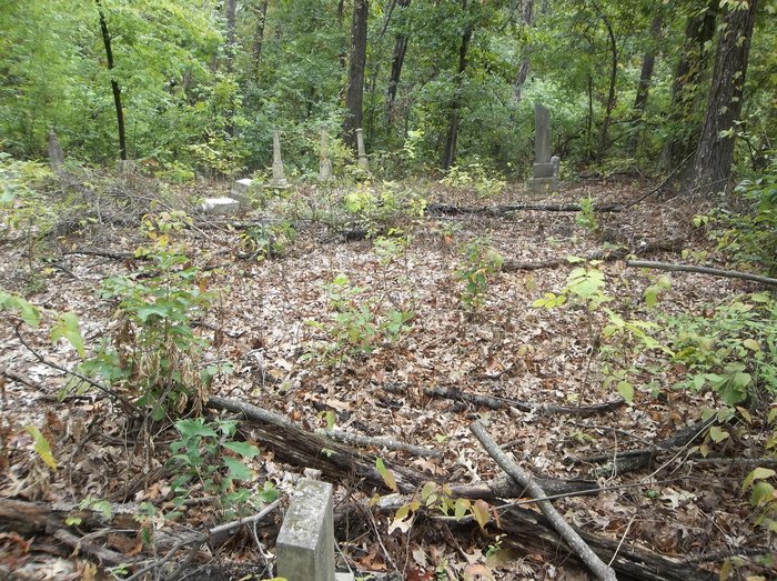
| Description | : | Cemetery is in Morris State Park. Very unkept with stones in poor condition. Located in the woods on the side of the hill. For best directions notify the homeowner at the residence closest to GPS cordination. |
frequently asked questions (FAQ):
-
Where is Stewart Cemetery?
Stewart Cemetery is located at Dunklin County ,Missouri ,USA.
-
Stewart Cemetery cemetery's updated grave count on graveviews.com?
0 memorials
-
Where are the coordinates of the Stewart Cemetery?
Latitude: 36.5571970
Longitude: -90.0469170

Nearby Cemetories:
1. Elder Cemetery
Campbell, Dunklin County, USA
Coordinate: 36.5572014, -90.0492020
2. Riddle Hill Cemetery
Malden, Dunklin County, USA
Coordinate: 36.5646782, -90.0587234
3. Vincent Cemetery
Campbell, Dunklin County, USA
Coordinate: 36.5910988, -90.0586014
4. Gunnels Cemetery
Campbell, Dunklin County, USA
Coordinate: 36.5248985, -90.0655365
5. Tucker Cemetery
Campbell, Dunklin County, USA
Coordinate: 36.5168991, -90.0639038
6. Rosewood Cemetery
Malden, Dunklin County, USA
Coordinate: 36.5535400, -89.9749100
7. Park Cemetery
Malden, Dunklin County, USA
Coordinate: 36.5555992, -89.9717026
8. Bethany Cemetery
Campbell, Dunklin County, USA
Coordinate: 36.6157951, -90.0688553
9. Four Mile Cemetery
Campbell, Dunklin County, USA
Coordinate: 36.5078011, -90.0943985
10. Woodlawn Cemetery Landess Addition
Campbell, Dunklin County, USA
Coordinate: 36.5011864, -90.0826797
11. Woodlawn Cemetery
Campbell, Dunklin County, USA
Coordinate: 36.5003014, -90.0860977
12. Memorial Park Cemetery
Malden, Dunklin County, USA
Coordinate: 36.5802994, -89.9697037
13. Macedonia Cemetery
Malden, Dunklin County, USA
Coordinate: 36.5889015, -89.9664001
14. Stevens Chapel Cemetery
Malden, Dunklin County, USA
Coordinate: 36.6185989, -89.9918976
15. Gravel Hill Cemetery
Campbell, Dunklin County, USA
Coordinate: 36.4958000, -90.1213989
16. Rocky Hill Cemetery
Campbell, Dunklin County, USA
Coordinate: 36.4963989, -90.1256027
17. Saint Teresas Cemetery
Glennonville, Dunklin County, USA
Coordinate: 36.5825300, -90.1529500
18. Oak Grove Cemetery
Dunklin County, USA
Coordinate: 36.4763985, -89.9969025
19. Lynne Oak Cemetery
Clarkton, Dunklin County, USA
Coordinate: 36.4653015, -90.0121994
20. Mount Gilead Cemetery
Clarkton, Dunklin County, USA
Coordinate: 36.4852982, -89.9672012
21. North Canaan Cemetery
Gibson, Dunklin County, USA
Coordinate: 36.4613991, -90.0318985
22. Tompkins Family Cemetery
Glennonville, Dunklin County, USA
Coordinate: 36.6069160, -90.1575210
23. Sacred Heart Cemetery
Dunklin County, USA
Coordinate: 36.5184400, -90.1818500
24. Chalk Bluff Cemetery
Clay County, USA
Coordinate: 36.4779816, -90.1641693