
| Memorials | : | 0 |
| Location | : | Rotenburg an der Fulda, Landkreis Hersfeld-Rotenburg, Germany |
| Coordinate | : | 50.9972935, 9.7291665 |
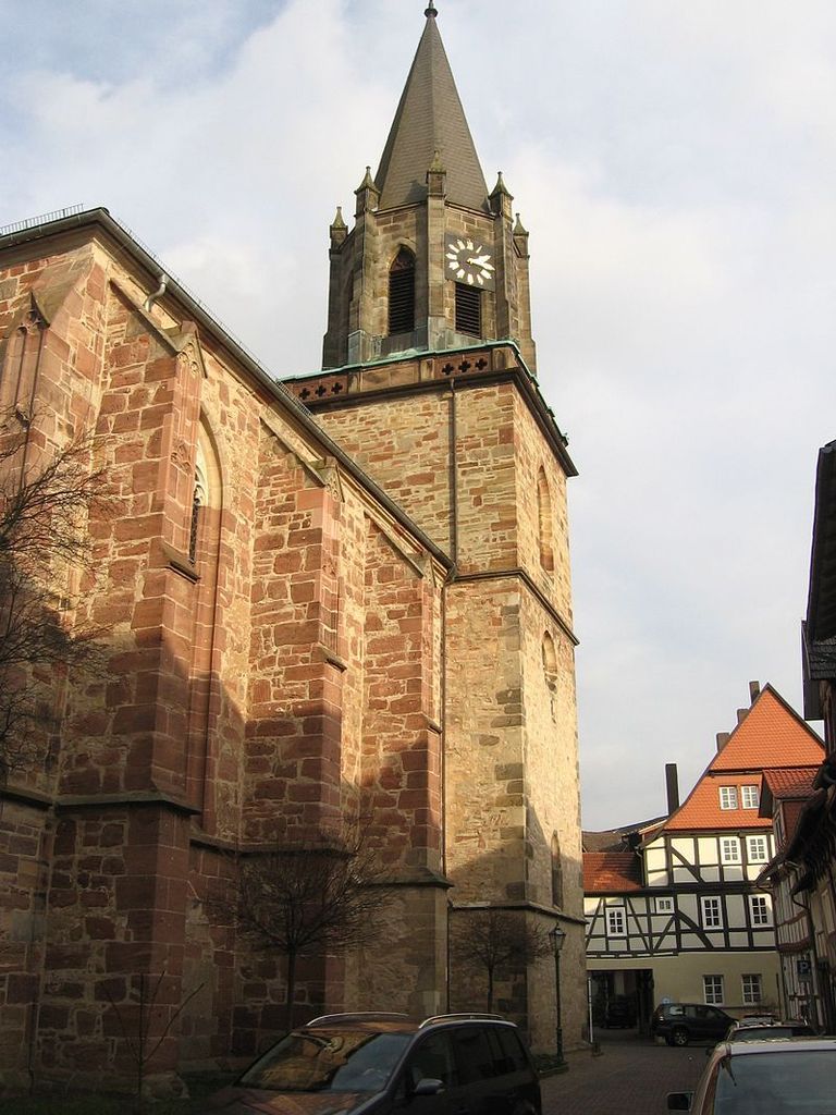
| Description | : | In the "new town" district of Rotenburg has been build from 1370 the Gothic collegiate church "St. Elizabeth and Mary" (today Protestant parish church of the new town) for the Kollegiatsstift Rotenburg. After the completion and consecration of the choir and the construction of two nave bays, the work had been interrupted for more than a century. The three-nave and three-bay church hall was built between 1484 and 1501. In 1651, a tomb for Landgrave Hermann IV of Hesse-Rotenburg and his second wife Kunigunde Juliane of Anhalt-Dessau was build on the ground floor of the northern tower. The increased south... Read More |
frequently asked questions (FAQ):
-
Where is Stiftskirche St. Elisabeth und Marien?
Stiftskirche St. Elisabeth und Marien is located at Kirchengemeinde Rotenburg Neustadt Kirchplatz 3 Rotenburg an der Fulda, Landkreis Hersfeld-Rotenburg ,Hessen , 36199Germany.
-
Stiftskirche St. Elisabeth und Marien cemetery's updated grave count on graveviews.com?
0 memorials
-
Where are the coordinates of the Stiftskirche St. Elisabeth und Marien?
Latitude: 50.9972935
Longitude: 9.7291665
Nearby Cemetories:
1. Rotenburg an der Fulda Civil Cemetery
Rotenburg an der Fulda, Landkreis Hersfeld-Rotenburg, Germany
Coordinate: 50.9999400, 9.7355900
2. Friedhof Bebra
Bebra, Landkreis Hersfeld-Rotenburg, Germany
Coordinate: 50.9782530, 9.7993674
3. Heinebach
Alheim, Landkreis Hersfeld-Rotenburg, Germany
Coordinate: 51.0472640, 9.6698400
4. Friedhof Oberellenbach
Alheim, Landkreis Hersfeld-Rotenburg, Germany
Coordinate: 51.0221190, 9.6343620
5. Jüdischer Friedhof Binsförth
Binsförth, Schwalm-Eder-Kreis, Germany
Coordinate: 51.0639400, 9.5667610
6. Friedhof Machtlos
Machtlos (Ronshausen), Landkreis Hersfeld-Rotenburg, Germany
Coordinate: 50.9666440, 9.9202040
7. Friedhof Obergeis
Obergeis, Landkreis Hersfeld-Rotenburg, Germany
Coordinate: 50.9054621, 9.5932509
8. Evangelische Pfarrkirche
Spangenberg, Schwalm-Eder-Kreis, Germany
Coordinate: 51.1166800, 9.6673100
9. Friedhof Aua
Aua, Landkreis Hersfeld-Rotenburg, Germany
Coordinate: 50.9147715, 9.5722998
10. Jüdischer Friedhof Spangenberg
Spangenberg, Schwalm-Eder-Kreis, Germany
Coordinate: 51.1208458, 9.6664607
11. Friedhof Niederbeisheim
Niederbeisheim, Schwalm-Eder-Kreis, Germany
Coordinate: 51.0391129, 9.5282598
12. Friedhof Lautenhausen
Lautenhausen, Landkreis Hersfeld-Rotenburg, Germany
Coordinate: 50.8711240, 9.8852130
13. Unterneurode Friedhof
Unterneurode, Landkreis Hersfeld-Rotenburg, Germany
Coordinate: 50.8615900, 9.9131750
14. Bergfriedhof Waldkappel
Waldkappel, Werra-Meißner-Kreis, Germany
Coordinate: 51.1500977, 9.8796966
15. Gethsemane Friedhof
Gethsemane, Landkreis Hersfeld-Rotenburg, Germany
Coordinate: 50.8598430, 9.9193000
16. Bengendorf Friedhof
Bengendorf, Landkreis Hersfeld-Rotenburg, Germany
Coordinate: 50.8988335, 9.9755900
17. Friedhof Ulfen
Ulfen, Werra-Meißner-Kreis, Germany
Coordinate: 51.0446406, 10.0163870
18. Alter Kirchhof Heimboldshausen
Landkreis Hersfeld-Rotenburg, Germany
Coordinate: 50.8550370, 9.9539320
19. Friedhof Beuern
Beuern, Schwalm-Eder-Kreis, Germany
Coordinate: 51.1184282, 9.4683246
20. Friedhof Niederaula
Niederaula, Landkreis Hersfeld-Rotenburg, Germany
Coordinate: 50.8047936, 9.5986846
21. Friedhof Röhrigshof
Röhrigshof, Landkreis Hersfeld-Rotenburg, Germany
Coordinate: 50.8437090, 9.9591740
22. Friedhof Buchenau
Eiterfeld, Landkreis Fulda, Germany
Coordinate: 50.7793796, 9.7671754
23. Friedhof Gensungen
Gensungen, Schwalm-Eder-Kreis, Germany
Coordinate: 51.1319441, 9.4407199
24. Friedhof Baumbach
Alheim, Landkreis Hersfeld-Rotenburg, Germany
Coordinate: 51.2223790, 9.6637650