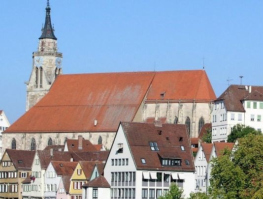
| Memorials | : | 0 |
| Location | : | Tübingen, Landkreis Tübingen, Germany |
| Coordinate | : | 48.5201912, 9.0562325 |
| Description | : | The Stiftskirche (St. George's Collegiate Church) is a church located in Tübingen, Baden-Württemberg, Germany. It is a late gothic structure built by Peter von Koblenz in 1470. When the Duke of Württemberg supported the Reformation he had the interior of the church changed. A nave (the choir area) was transformed into a burial hall for the nobles of the House of Württemberg. A cemetery surrounding the church was closed in 1587 and the area reused. Contact: Stiftskirchengemeinde Tübingen Neckarhalde 27 72070 Tübingen fon: 01149 - (07071) 43151 fax: 01149 - (07071) 440186 This is one of nearly 20 burial grounds in the city of Tübingen: Municipal Cemeteries: ► Stadtfriedhof... Read More |
frequently asked questions (FAQ):
-
Where is Stiftskirche zu St. Georg Tübingen?
Stiftskirche zu St. Georg Tübingen is located at Am Holzmarkt Tübingen, Landkreis Tübingen ,Baden-Württemberg , 72072Germany.
-
Stiftskirche zu St. Georg Tübingen cemetery's updated grave count on graveviews.com?
0 memorials
-
Where are the coordinates of the Stiftskirche zu St. Georg Tübingen?
Latitude: 48.5201912
Longitude: 9.0562325
Nearby Cemetories:
1. Ammerkirchhof
Tübingen, Landkreis Tübingen, Germany
Coordinate: 48.5235050, 9.0557650
2. Stadtfriedhof Tübingen
Tübingen, Landkreis Tübingen, Germany
Coordinate: 48.5268440, 9.0568110
3. Bergfriedhof Tübingen
Tübingen, Landkreis Tübingen, Germany
Coordinate: 48.5038000, 9.0665000
4. Friedhof Tübingen-Lustnau
Tübingen, Landkreis Tübingen, Germany
Coordinate: 48.5295000, 9.0860000
5. Friedhof Derendingen
Tübingen, Landkreis Tübingen, Germany
Coordinate: 48.4982000, 9.0449000
6. Jüdischer Friedhof Wankheim
Kusterdingen, Landkreis Tübingen, Germany
Coordinate: 48.5086230, 9.1004480
7. Kusterdingen Jüdischer Friedhof
Kusterdingen, Landkreis Tübingen, Germany
Coordinate: 48.5085183, 9.1010053
8. Friedhof Tübingen-Weilheim
Tübingen, Landkreis Tübingen, Germany
Coordinate: 48.4881000, 9.0407000
9. Friedhof Hagelloch
Tübingen, Landkreis Tübingen, Germany
Coordinate: 48.5411000, 9.0147000
10. Friedhof Hirschau
Tübingen, Landkreis Tübingen, Germany
Coordinate: 48.5020000, 9.0085000
11. Friedhof Wankheim
Wankheim, Landkreis Tübingen, Germany
Coordinate: 48.5006360, 9.1040450
12. Kloster Bebenhausen
Tübingen, Landkreis Tübingen, Germany
Coordinate: 48.5612240, 9.0603840
13. Friedhof Bebenhausen
Tübingen, Landkreis Tübingen, Germany
Coordinate: 48.5619000, 9.0605000
14. Friedhof Kilchberg
Tübingen, Landkreis Tübingen, Germany
Coordinate: 48.4842000, 9.0182000
15. Friedhof Kusterdingen
Kusterdingen, Landkreis Tübingen, Germany
Coordinate: 48.5209390, 9.1242050
16. Alter Friedhof Pfrondorf
Tübingen, Landkreis Tübingen, Germany
Coordinate: 48.5490000, 9.1095000
17. Neuer Friedhof Pfrondorf
Tübingen, Landkreis Tübingen, Germany
Coordinate: 48.5526000, 9.1085000
18. Friedhof Stockach
Stockach, Landkreis Tübingen, Germany
Coordinate: 48.4726940, 9.0800960
19. Friedhof Immenhausen
Immenhausen, Landkreis Tübingen, Germany
Coordinate: 48.4797940, 9.1066330
20. Friedhof Unterjesingen
Tübingen, Landkreis Tübingen, Germany
Coordinate: 48.5288000, 8.9778000
21. Friedhof Mähringen
Mahringen, Landkreis Tübingen, Germany
Coordinate: 48.4833190, 9.1153320
22. Friedhof Bühl in Tübingen
Tübingen, Landkreis Tübingen, Germany
Coordinate: 48.4807040, 8.9981700
23. Friedwald Schönbuch
Hagelloch, Landkreis Tübingen, Germany
Coordinate: 48.5531750, 8.9879110
24. Friedhof Jettenburg
Jettenburg, Landkreis Tübingen, Germany
Coordinate: 48.5024260, 9.1369370


