
| Memorials | : | 0 |
| Location | : | Marshall County, USA |
| Coordinate | : | 34.6935850, -89.3045600 |
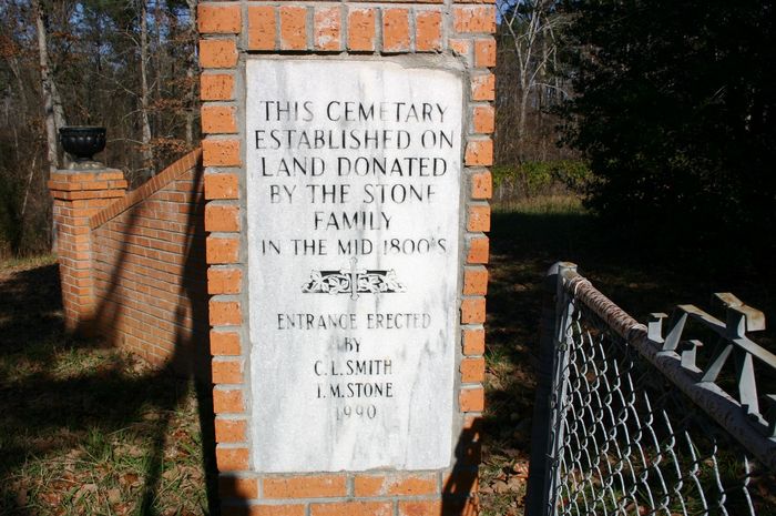
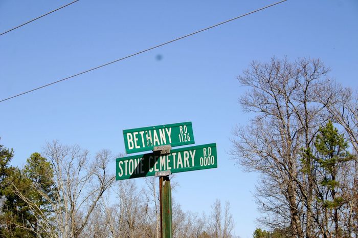
| Description | : | Drive down Hwy 178, south from Holly Springs, MS. Turn left on Bethany Road. Cross over Hwy 78. When you see Forestry Road 661A on the left, you'll see Stone Cemetery Road just ahead on the right. The cemetery is located on a hill at the end of the road. |
frequently asked questions (FAQ):
-
Where is Stone Cemetery?
Stone Cemetery is located at Marshall County ,Mississippi ,USA.
-
Stone Cemetery cemetery's updated grave count on graveviews.com?
0 memorials
-
Where are the coordinates of the Stone Cemetery?
Latitude: 34.6935850
Longitude: -89.3045600

Nearby Cemetories:
1. Bethany Baptist Church Cemetery
Potts Camp, Marshall County, USA
Coordinate: 34.7130520, -89.3023180
2. Clayton Cemetery
Benton County, USA
Coordinate: 34.6958008, -89.2696991
3. Chewalla Primitive Baptist Church Cemetery
Potts Camp, Marshall County, USA
Coordinate: 34.6812570, -89.3399700
4. Sardis Cemetery
Lake Center, Marshall County, USA
Coordinate: 34.7060000, -89.3430000
5. Temperance Hill Cemetery
Potts Camp, Marshall County, USA
Coordinate: 34.6796989, -89.3427963
6. East Mount Pleasant Cemetery
Marshall County, USA
Coordinate: 34.7293870, -89.3060420
7. Potts Camp Cemetery
Potts Camp, Marshall County, USA
Coordinate: 34.6499540, -89.3090580
8. Boatwright Cemetery
Potts Camp, Marshall County, USA
Coordinate: 34.6893997, -89.3630981
9. Harmony Cemetery
Benton County, USA
Coordinate: 34.7421989, -89.2917023
10. Harmony Cemetery
Ashland, Benton County, USA
Coordinate: 34.7424730, -89.2916150
11. Potts Camp Church of Christ Cemetery
Potts Camp, Marshall County, USA
Coordinate: 34.6417170, -89.3013060
12. Saint Marys Church Cemetery
Potts Camp, Marshall County, USA
Coordinate: 34.6413150, -89.3036300
13. Reid Gift Church Cemetery
Potts Camp, Marshall County, USA
Coordinate: 34.6415200, -89.2987420
14. Charity Hill Cemetery
Lake Center, Marshall County, USA
Coordinate: 34.7017300, -89.3679880
15. Palestine Cemetery
Benton County, USA
Coordinate: 34.6866989, -89.2407990
16. Butler Cemetery
Potts Camp, Marshall County, USA
Coordinate: 34.6418991, -89.3225021
17. Lonoke Cemetery
Benton County, USA
Coordinate: 34.7228012, -89.2493973
18. Holbrook Family Cemetery
Lake Center, Marshall County, USA
Coordinate: 34.7233740, -89.3610190
19. Moody Cemetery
Lake Center, Marshall County, USA
Coordinate: 34.6676000, -89.3647990
20. Royston Chapel C. M. E. Church Cemetery
Ashland, Benton County, USA
Coordinate: 34.7508550, -89.2803370
21. Saint Pauls Cemetery
Potts Camp, Marshall County, USA
Coordinate: 34.7147050, -89.3747230
22. Shawnee Cemetery
Benton County, USA
Coordinate: 34.7705994, -89.2874985
23. Chestnut Grove Cemetery
Marshall County, USA
Coordinate: 34.7752991, -89.3122025
24. Rising Star MB Church Cemetery
Holly Springs, Marshall County, USA
Coordinate: 34.7554470, -89.3775410