
| Memorials | : | 0 |
| Location | : | Bland, Gasconade County, USA |
| Coordinate | : | 38.3016701, -91.6327820 |
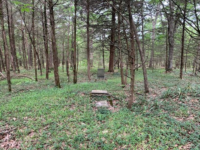
| Description | : | The cemetery is located on the old Thomas H. Smith farm and has been lost for many years. Very remote and requires off-road vehicles to reach the location. The oldest know grave is that of Thomas H. Smith who died in 1833 and the last grave was that of Virginia Margaret Smith who died in about 1940. Most, if not all of the graves at the cemetery are family members of Thomas H. Smith and of Thomas Washington Smith. Permission and assistance is required to reach the cemetery. |
frequently asked questions (FAQ):
-
Where is Thomas H Smith Family Cemetery?
Thomas H Smith Family Cemetery is located at Bland, Gasconade County ,Missouri ,USA.
-
Thomas H Smith Family Cemetery cemetery's updated grave count on graveviews.com?
0 memorials
-
Where are the coordinates of the Thomas H Smith Family Cemetery?
Latitude: 38.3016701
Longitude: -91.6327820
Nearby Cemetories:
1. Old Bland Cemetery
Bland, Gasconade County, USA
Coordinate: 38.3125000, -91.6260986
2. Union Cemetery
Bland, Gasconade County, USA
Coordinate: 38.2933006, -91.6216965
3. Saint Michael Cemetery
Gasconade County, USA
Coordinate: 38.2757988, -91.6211014
4. Crider Cemetery
Gasconade County, USA
Coordinate: 38.2733002, -91.6294022
5. Old United Methodist Cemetery
Gasconade County, USA
Coordinate: 38.3283005, -91.6035995
6. Old Bland Methodist Cemetery
Gasconade County, USA
Coordinate: 38.3302193, -91.6066666
7. Cleavesville Cemetery
Bland, Gasconade County, USA
Coordinate: 38.2707300, -91.6057300
8. Howard Cemetery
Canaan, Gasconade County, USA
Coordinate: 38.2888985, -91.5832977
9. White Church Cemetery
Byron, Osage County, USA
Coordinate: 38.3256240, -91.6790840
10. Campbell Cemetery
Belle, Maries County, USA
Coordinate: 38.2588997, -91.6718979
11. Heyer Cemetery
Osage County, USA
Coordinate: 38.3241997, -91.6968994
12. Countryside Memorial Gardens
Canaan, Gasconade County, USA
Coordinate: 38.3145600, -91.5480400
13. Lucas Cemetery
Redbird, Gasconade County, USA
Coordinate: 38.2488980, -91.5664960
14. Backues Cemetery
Belle, Maries County, USA
Coordinate: 38.2846820, -91.7253680
15. Liberty Baptist Cemetery
Owensville, Gasconade County, USA
Coordinate: 38.3194800, -91.5399200
16. New Bethel Cemetery
Bland, Gasconade County, USA
Coordinate: 38.3736760, -91.6016650
17. New Woollam Zoar Cemetery
New Woollam, Gasconade County, USA
Coordinate: 38.3638580, -91.5706920
18. Liberty Cemetery
Belle, Maries County, USA
Coordinate: 38.2606010, -91.7266998
19. Francis Cemetery
Byron, Osage County, USA
Coordinate: 38.3264008, -91.7358017
20. Feuersville Lutheran Church Cemetery
Feuersville, Osage County, USA
Coordinate: 38.3768997, -91.6832962
21. Grove Dale Cemetery
Belle, Maries County, USA
Coordinate: 38.2203000, -91.6681000
22. Branson Cemetery
Gasconade County, USA
Coordinate: 38.3731003, -91.5691986
23. Travis Cemetery
Belle, Maries County, USA
Coordinate: 38.2518997, -91.7288971
24. Advent Cemetery
Gasconade County, USA
Coordinate: 38.3764000, -91.5669022