
| Memorials | : | 3 |
| Location | : | Whiting, Jackson County, USA |
| Coordinate | : | 39.5062100, -95.5980710 |
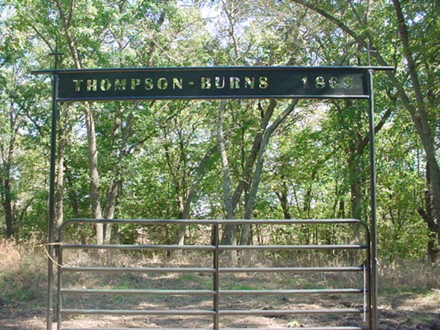
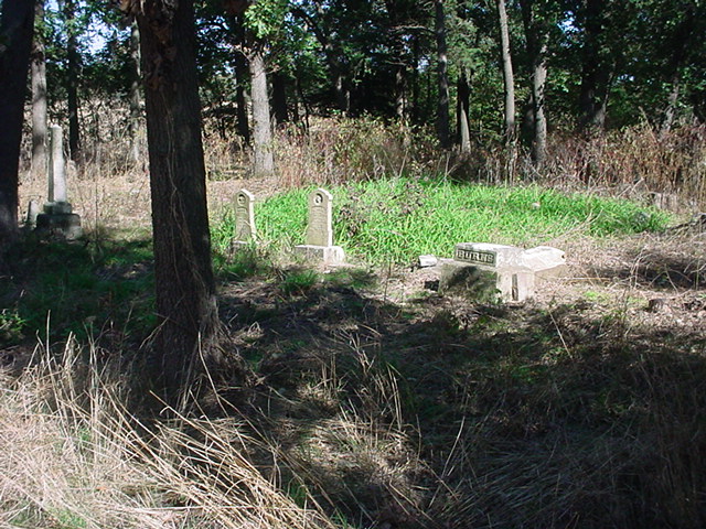
| Description | : | Dan Fenton of Jackson County researched this cemetery in March 2003. Here is his findings: Thomson / Burns Cemetery southeast quarter of section 23 in Straight Creek Township. It is about 100 feet up a dirt one lane road leading north into a cultivated field, on the east side. There seems to be two or three rows of graves running north and south, containing at least twenty memorial stones, most are not on their foundations and many are unreadable. There is one pillar stone for Richard M. Burns still upright. ---------- 2010 information and headstone photos from Nina Kaul,... Read More |
frequently asked questions (FAQ):
-
Where is Thompson-Burns Cemetery?
Thompson-Burns Cemetery is located at unmarked Thompson/Burns Cem.- 1.5 miles E. of jct. Co Rd 254 and Rd X in trees Whiting, Jackson County ,Kansas ,USA.
-
Thompson-Burns Cemetery cemetery's updated grave count on graveviews.com?
3 memorials
-
Where are the coordinates of the Thompson-Burns Cemetery?
Latitude: 39.5062100
Longitude: -95.5980710
Nearby Cemetories:
1. Estes Cemetery
Jackson County, USA
Coordinate: 39.5346985, -95.6168976
2. Larkinburg Cemetery
Jackson County, USA
Coordinate: 39.4794006, -95.5706024
3. Wells Family Cemetery
Jackson County, USA
Coordinate: 39.4677963, -95.5827866
4. Wyant Family Cemetery
Holton, Jackson County, USA
Coordinate: 39.4778520, -95.6614440
5. Miller Cemetery
Arrington, Atchison County, USA
Coordinate: 39.4855995, -95.5274963
6. Van Winkle Cemetery
Arrington, Atchison County, USA
Coordinate: 39.4652214, -95.5409927
7. Bradley Family Cemetery
Holton, Jackson County, USA
Coordinate: 39.4644928, -95.6813889
8. Muscotah Cemetery
Muscotah, Atchison County, USA
Coordinate: 39.5539017, -95.5121994
9. Patton - Robertson Family Cemetery
Larkinburg, Atchison County, USA
Coordinate: 39.4342900, -95.5404000
10. Wills Cemetery
Muscotah, Atchison County, USA
Coordinate: 39.5596400, -95.5002800
11. Spring Hill Cemetery
Whiting, Jackson County, USA
Coordinate: 39.6021996, -95.6121979
12. Ernst Family Cemetery
Arrington, Atchison County, USA
Coordinate: 39.4533900, -95.4781800
13. Hamon Family Cemetery
Arrington, Atchison County, USA
Coordinate: 39.4424400, -95.4842377
14. Denison Cemetery
Denison, Jackson County, USA
Coordinate: 39.3973389, -95.6278000
15. Brick Cemetery
Jackson County, USA
Coordinate: 39.4206009, -95.7099991
16. South Denison Cemetery
Denison, Jackson County, USA
Coordinate: 39.3833008, -95.6219025
17. Holton Cemetery
Holton, Jackson County, USA
Coordinate: 39.4611015, -95.7583008
18. Mount Calvary Catholic Cemetery
Holton, Jackson County, USA
Coordinate: 39.4700012, -95.7702026
19. Netawaka Cemetery
Netawaka, Jackson County, USA
Coordinate: 39.6075300, -95.7223700
20. Smith Family Cemetery
Valley Falls, Jefferson County, USA
Coordinate: 39.4157295, -95.4602737
21. Abbuehl Family Cemetery
Valley Falls, Jefferson County, USA
Coordinate: 39.4038000, -95.4733900
22. Wheatland Cemetery
Atchison County, USA
Coordinate: 39.6453018, -95.5633011
23. Brush Creek Cemetery
Kennekuk, Atchison County, USA
Coordinate: 39.6096992, -95.4702988
24. Coal Creek Cemetery
Valley Falls, Jefferson County, USA
Coordinate: 39.4061089, -95.4594498