
| Memorials | : | 0 |
| Location | : | Newcastle-upon-Tyne, Metropolitan Borough of Newcastle upon Tyne, England |
| Coordinate | : | 54.9700140, -1.6211580 |
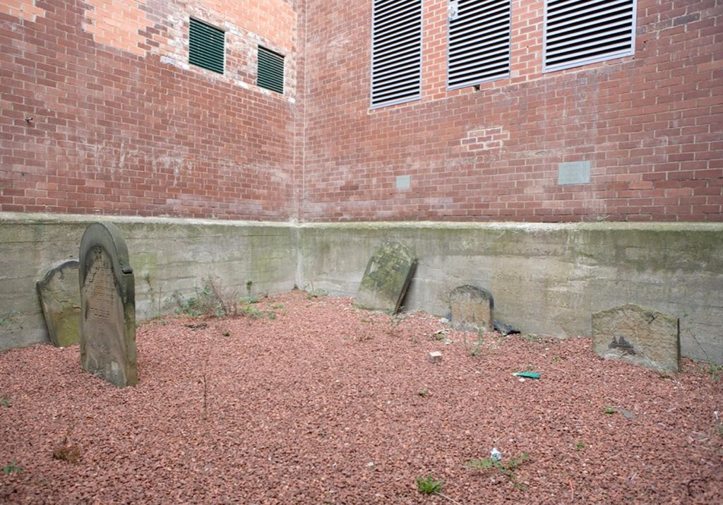
| Description | : | In 1835, Newcastle's Jewish community purchased a 250 square yards plot of land north of Thornton Street for use as a burial ground close to the Temple Street synagogue. Within 30 years however this area had been densely developed and the plot was allocated for a new theatre. Despite appeals, the Jewish community lost their battle for their cemetery. They were promised however that the 55 square yards which had already been used would be untouched by development, hence the small site which survives today. Only five grave stones are left. The Hebrew inscriptions are eroded and only... Read More |
frequently asked questions (FAQ):
-
Where is Thornton Street Jewish Cemetery?
Thornton Street Jewish Cemetery is located at Newcastle-upon-Tyne, Metropolitan Borough of Newcastle upon Tyne ,Tyne and Wear ,England.
-
Thornton Street Jewish Cemetery cemetery's updated grave count on graveviews.com?
0 memorials
-
Where are the coordinates of the Thornton Street Jewish Cemetery?
Latitude: 54.9700140
Longitude: -1.6211580
Nearby Cemetories:
1. St. Mary's Cathedral and Churchyard
Newcastle-upon-Tyne, Metropolitan Borough of Newcastle upon Tyne, England
Coordinate: 54.9690970, -1.6193680
2. St Andrew Churchyard
Newcastle-upon-Tyne, Metropolitan Borough of Newcastle upon Tyne, England
Coordinate: 54.9736273, -1.6178198
3. St Paul's Churchyard
Newcastle-upon-Tyne, Metropolitan Borough of Newcastle upon Tyne, England
Coordinate: 54.9722280, -1.6301050
4. Newcastle Cathedral
Newcastle-upon-Tyne, Metropolitan Borough of Newcastle upon Tyne, England
Coordinate: 54.9700730, -1.6111580
5. Westgate Hill General Cemetery
Newcastle-upon-Tyne, Metropolitan Borough of Newcastle upon Tyne, England
Coordinate: 54.9719880, -1.6313500
6. Newcastle upon Tyne Greyfriars
Newcastle-upon-Tyne, Metropolitan Borough of Newcastle upon Tyne, England
Coordinate: 54.9741300, -1.6119300
7. All Saints Churchyard
Newcastle-upon-Tyne, Metropolitan Borough of Newcastle upon Tyne, England
Coordinate: 54.9701690, -1.6069110
8. St. Thomas' Churchyard
Newcastle-upon-Tyne, Metropolitan Borough of Newcastle upon Tyne, England
Coordinate: 54.9782000, -1.6130680
9. St Mary's Churchyard
Gateshead, Metropolitan Borough of Gateshead, England
Coordinate: 54.9665361, -1.6039875
10. St Josephs Roman Catholic Church
Gateshead, Metropolitan Borough of Gateshead, England
Coordinate: 54.9594469, -1.6018142
11. Elswick Cemetery
Newcastle-upon-Tyne, Metropolitan Borough of Newcastle upon Tyne, England
Coordinate: 54.9688000, -1.6490400
12. Saint Nicholas Cemetery
Newcastle-upon-Tyne, Metropolitan Borough of Newcastle upon Tyne, England
Coordinate: 54.9804950, -1.6449710
13. Jesmond Old Cemetery
Newcastle-upon-Tyne, Metropolitan Borough of Newcastle upon Tyne, England
Coordinate: 54.9842420, -1.5995580
14. All Saints Cemetery
Newcastle-upon-Tyne, Metropolitan Borough of Newcastle upon Tyne, England
Coordinate: 54.9849240, -1.5980980
15. Gateshead East Cemetery
Gateshead, Metropolitan Borough of Gateshead, England
Coordinate: 54.9560360, -1.5939800
16. St. Andrew & Jesmond Cemetery
Newcastle-upon-Tyne, Metropolitan Borough of Newcastle upon Tyne, England
Coordinate: 54.9899800, -1.6080400
17. St James Churchyard
Benwell, Metropolitan Borough of Newcastle upon Tyne, England
Coordinate: 54.9710660, -1.6613400
18. Saltwell Cemetery
Gateshead, Metropolitan Borough of Gateshead, England
Coordinate: 54.9407400, -1.6068600
19. Saltwell Crematorium
Gateshead, Metropolitan Borough of Gateshead, England
Coordinate: 54.9406000, -1.6066100
20. Garden House Cemetery
Swalwell, Metropolitan Borough of Gateshead, England
Coordinate: 54.9511010, -1.6692210
21. Ashburton Roman Catholic Cemetery
Gosforth, Metropolitan Borough of Newcastle upon Tyne, England
Coordinate: 55.0029370, -1.6316110
22. Byker and Heaton Cemetery
Newcastle-upon-Tyne, Metropolitan Borough of Newcastle upon Tyne, England
Coordinate: 54.9944160, -1.5796810
23. West Road Cemetery and Crematorium
Newcastle-upon-Tyne, Metropolitan Borough of Newcastle upon Tyne, England
Coordinate: 54.9835110, -1.6774750
24. St. John's Churchyard Gateshead Fell
Sheriff Hill, Metropolitan Borough of Gateshead, England
Coordinate: 54.9384680, -1.5882350