
| Memorials | : | 0 |
| Location | : | Brussels, Door County, USA |
| Coordinate | : | 44.7658030, -87.5405740 |
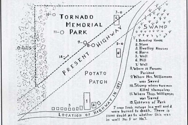
| Description | : | Tornado Memorial County Park is located on westbound County Road DK, west of its intersection with South Stevenson Pier Road, and east of its intersection with Tornado Road, Brussels, Wisconsin 54204. It is about 10 miles south of Sturgeon Bay, Door, Wisconsin Historical Markers read: TORNADO MEMORIAL PARK Established by Door County in November, 1927. Through trial and tribulation, in poverty and loneliness, in cold and fire, the pioneers struggled that their children might gain a competence. Here was the Village of Williamsonville with a population of 77 persons. On October 8, 1871, this village was blotted out by a tornado of fire. 60 persons sought refuge in an open field surrounding this spot and were burned to death. |
frequently asked questions (FAQ):
-
Where is Tornado Memorial Park?
Tornado Memorial Park is located at 1961 County Hwy DK and S Stevenson Pier Road Brussels, Door County ,Wisconsin , 54204USA.
-
Tornado Memorial Park cemetery's updated grave count on graveviews.com?
0 memorials
-
Where are the coordinates of the Tornado Memorial Park?
Latitude: 44.7658030
Longitude: -87.5405740
Nearby Cemetories:
1. Geise Cemetery
Maplewood, Door County, USA
Coordinate: 44.7694016, -87.5318985
2. Emmanuel Lutheran Cemetery
Brussels, Door County, USA
Coordinate: 44.7192300, -87.5472000
3. Saint Francis Church Cemetery
Brussels, Door County, USA
Coordinate: 44.7497890, -87.6044370
4. Forestville Cemetery
Maplewood, Door County, USA
Coordinate: 44.7477780, -87.4713890
5. Saint Marys Cemetery
Maplewood, Door County, USA
Coordinate: 44.7475000, -87.4705560
6. White Star Cemetery
Brussels, Door County, USA
Coordinate: 44.7701870, -87.6254570
7. Saint Josephs Catholic Cemetery
Brussels, Door County, USA
Coordinate: 44.8101300, -87.6010700
8. Saint John the Baptist Cemetery
Little Sturgeon, Door County, USA
Coordinate: 44.7934680, -87.6184260
9. Saint Mary's Cemetery
Forestville, Door County, USA
Coordinate: 44.7164001, -87.4772034
10. Precious Blood Cemetery
Brussels, Door County, USA
Coordinate: 44.8032200, -87.6193200
11. Salem Lutheran Cemetery
Nasewaupee, Door County, USA
Coordinate: 44.8273600, -87.4794500
12. Elton Schulties Memorial Cemetery
Nasewaupee, Door County, USA
Coordinate: 44.8278008, -87.4792023
13. Stevenson Cemetery
Little Sturgeon, Door County, USA
Coordinate: 44.8405991, -87.5622025
14. Saint Michaels Cemetery
Rosiere, Door County, USA
Coordinate: 44.6982994, -87.5986023
15. Emmanuel Lutheran Cemetery
Forestville, Door County, USA
Coordinate: 44.6906013, -87.5049973
16. Pilgrims Rest Cemetery
Sturgeon Bay, Door County, USA
Coordinate: 44.8333520, -87.4800970
17. Saint Peters Lutheran Cemetery
Forestville, Door County, USA
Coordinate: 44.6868600, -87.4799500
18. Saint Marys Catholic Cemetery
Namur, Door County, USA
Coordinate: 44.7299995, -87.6611023
19. Our Lady of the Snows Cemetery
Namur, Door County, USA
Coordinate: 44.7346001, -87.6664963
20. Schumacher Cemetery
Sturgeon Bay, Door County, USA
Coordinate: 44.8205986, -87.4235001
21. Saint Huberts Cemetery
Euren, Kewaunee County, USA
Coordinate: 44.6749992, -87.6128006
22. Brockhausen Cemetery
Forestville, Door County, USA
Coordinate: 44.6749992, -87.4642029
23. Forest Lutheran Cemetery
Carnot, Door County, USA
Coordinate: 44.7049690, -87.4186160
24. Qualman Family Burial Ground
Algoma, Kewaunee County, USA
Coordinate: 44.6627800, -87.4708900