
| Memorials | : | 1 |
| Location | : | Totland, Vågsøy kommune, Norway |
| Coordinate | : | 61.9323500, 5.3882100 |
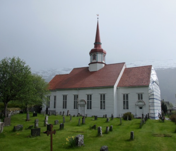
| Description | : | Totland Church (Norwegian: Totland kyrkje) is a parish church in Vågsøy Municipality in Sogn og Fjordane county, Norway. It is located in the village of Totland, along the shores of the Nordfjorden. The church is part of the Vågsøy parish in the Nordfjord deanery in the Diocese of Bjørgvin. The white, wooden church was built in 1912 to serve the people of the old Davik municipality who lived on the north side of the Nordfjorden. The architects Lars Sølvberg and Jens Sølvberg designed the building and it seats about 250 people. From 1912 until 1953, the chapel at Totland was... Read More |
frequently asked questions (FAQ):
-
Where is Totland Church Cemetery?
Totland Church Cemetery is located at Totland, Vågsøy kommune ,Sogn og Fjordane fylke ,Norway.
-
Totland Church Cemetery cemetery's updated grave count on graveviews.com?
1 memorials
-
Where are the coordinates of the Totland Church Cemetery?
Latitude: 61.9323500
Longitude: 5.3882100
Nearby Cemetories:
1. Davik Kyrkje
Davik, Bremanger kommune, Norway
Coordinate: 61.8922340, 5.5339340
2. Tytingvåg
Tytingevagen, Vågsøy kommune, Norway
Coordinate: 61.8995326, 5.0932122
3. St.Jetmund Cemetery
Vanylven kommune, Norway
Coordinate: 62.0747158, 5.5255741
4. Aalfoten Cemetery
Alfoten, Bremanger kommune, Norway
Coordinate: 61.8383500, 5.6764100
5. Stårheim Cemetery
Eid kommune, Norway
Coordinate: 61.9187935, 5.7656247
6. Syvde Cemetery
Syvdsbotn, Vanylven kommune, Norway
Coordinate: 62.0909174, 5.7445242
7. Eid
Nordfjordeid, Eid kommune, Norway
Coordinate: 61.9113170, 5.9848230
8. Larsnes
Larsnes, Sande kommune, Norway
Coordinate: 62.2008025, 5.5812030
9. Sande Cemetery
Sande kommune, Norway
Coordinate: 62.2009239, 5.5810327
10. Rovde Churchyard
Rovde, Vanylven kommune, Norway
Coordinate: 62.1760650, 5.7398690
11. Gursken Cemetery
Sande kommune, Norway
Coordinate: 62.2298568, 5.6196055
12. Kilsfjord Cemetery
Straumshamn, Volda kommune, Norway
Coordinate: 62.0646805, 6.0658150
13. Slettevoll Gravlund
Brandsoy, Flora kommune, Norway
Coordinate: 61.6007230, 5.1347610
14. Vereide Kirke Cemetery
Gloppen kommune, Norway
Coordinate: 61.8080150, 6.1416310
15. Florø Cemetery
Floro, Flora kommune, Norway
Coordinate: 61.5929210, 5.0381200
16. Leirshaugen
Volda kommune, Norway
Coordinate: 62.1455498, 6.0669422
17. Tjørvåg Cemetery
Tjørvåg, Herøy kommune, Norway
Coordinate: 62.2780206, 5.7415187
18. Moltu
Herøy kommune, Norway
Coordinate: 62.2986106, 5.6438986
19. Gimmestad Cemetery
Gloppen, Gloppen kommune, Norway
Coordinate: 61.7721843, 6.1442135
20. Fredly Cemetery
Sandane, Gloppen kommune, Norway
Coordinate: 61.7664730, 6.1950580
21. Kvalsund
Sande kommune, Norway
Coordinate: 62.3420098, 5.6013368
22. Ørsta kyrkje cemetery
Orsta, Ørsta kommune, Norway
Coordinate: 62.2003030, 6.1300280
23. Naustdal Cemetery
Naustdal i Sunnfjord, Naustdal kommune, Norway
Coordinate: 61.5089140, 5.7161610
24. Austefjord Cemetery
Volda kommune, Norway
Coordinate: 62.0616528, 6.3252816