
| Memorials | : | 0 |
| Location | : | Trade, Johnson County, USA |
| Phone | : | 423-727-7554 |
| Website | : | www.trademethodist.org/ |
| Coordinate | : | 36.3496800, -81.7441400 |
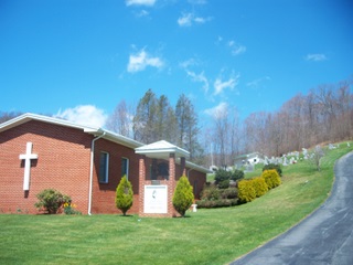
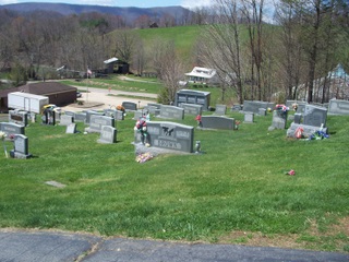
| Description | : | The church is in Tennessee on US Hwy 421 approximately one mile west of the North Carolina border. The cemetery is located on the east side of the Highway on the hill behind the church. It is just before the intersection of US Hwy 421 and TN Hwy 88. The cemetery is on community property but maintained by the Trade United Methodist Church. The town of Trade is the second oldest town in Tennessee and has a number of old graves. It is well maintained but on a steep hill. |
frequently asked questions (FAQ):
-
Where is Trade United Methodist Church Cemetery?
Trade United Methodist Church Cemetery is located at 11207 Hwy 421 South Trade, Johnson County ,Tennessee , 37691USA.
-
Trade United Methodist Church Cemetery cemetery's updated grave count on graveviews.com?
0 memorials
-
Where are the coordinates of the Trade United Methodist Church Cemetery?
Latitude: 36.3496800
Longitude: -81.7441400
Nearby Cemetories:
1. Reece Family Cemetery
Trade, Johnson County, USA
Coordinate: 36.3459100, -81.7288800
2. Dotson Family Cemetery
Trade, Johnson County, USA
Coordinate: 36.3624300, -81.7413200
3. Maine-Miller Cemetery
Johnson County, USA
Coordinate: 36.3575400, -81.7582600
4. Jenkins Cemetery
Trade, Johnson County, USA
Coordinate: 36.3603600, -81.7270200
5. Richard Arnold Cemetery
Trade, Johnson County, USA
Coordinate: 36.3685800, -81.7565100
6. Greer Cemetery
Johnson County, USA
Coordinate: 36.3706017, -81.7375031
7. Eggers Cemetery
Watauga County, USA
Coordinate: 36.3299330, -81.7590310
8. Reece Cemetery
Trade, Johnson County, USA
Coordinate: 36.3649600, -81.7743000
9. Ashley Cemetery
Forge Creek, Johnson County, USA
Coordinate: 36.3581900, -81.7785200
10. Dotson-Wilson Cemetery
Trade, Johnson County, USA
Coordinate: 36.3756170, -81.7633870
11. Parks Cemetery
Trade, Johnson County, USA
Coordinate: 36.3845900, -81.7636900
12. Potter Cemetery
Trade, Johnson County, USA
Coordinate: 36.3875200, -81.7526400
13. McFadden Cemetery
Trade, Johnson County, USA
Coordinate: 36.3817320, -81.7714550
14. Mahala Cemetery
Trade, Johnson County, USA
Coordinate: 36.3876920, -81.7561130
15. Wilson William Cemetery
Trade, Johnson County, USA
Coordinate: 36.3821640, -81.7714330
16. Wallace Cemetery
Johnson County, USA
Coordinate: 36.3891983, -81.7442017
17. Snyder Cemetery
Johnson County, USA
Coordinate: 36.3911018, -81.7469025
18. Eggers Cemetery
Cove Creek Township, Watauga County, USA
Coordinate: 36.3111600, -81.7640800
19. Snyder-Rash Cemetery
Mountain City, Johnson County, USA
Coordinate: 36.3914600, -81.7465300
20. Artie South Burial Site
Pottertown, Watauga County, USA
Coordinate: 36.3541560, -81.6924370
21. Glen Brown Family Cemetery
Pottertown, Watauga County, USA
Coordinate: 36.3557030, -81.6893360
22. Daniel and Ham Wallace Cemetery
Trade, Johnson County, USA
Coordinate: 36.3925100, -81.7630000
23. Foister Cemetery
Trade, Johnson County, USA
Coordinate: 36.3952400, -81.7509840
24. Maine Cemetery
Watauga County, USA
Coordinate: 36.3443985, -81.6857986