
| Memorials | : | 0 |
| Location | : | Leaday, Coleman County, USA |
| Coordinate | : | 31.5614240, -99.6920010 |
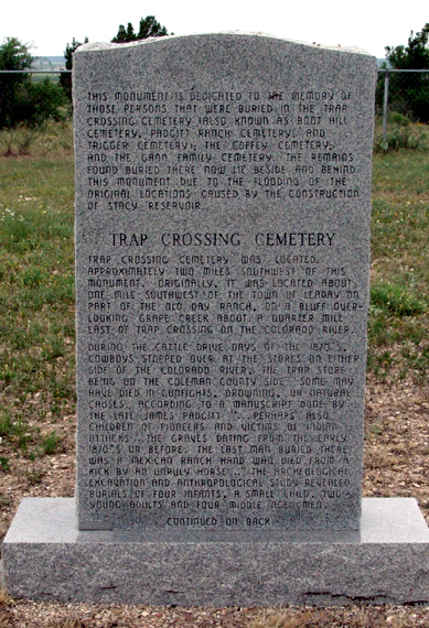
| Description | : | This old abandoned cemetery has been called Trap Crossing Cemetery, Boot Hill Cemetery, and Padgitt Ranch Cemetery. It was located about one mile southwest of Leaday on part of the old Day Ranch, on a bluff overlooking Grape Creek, about a quarter mile east of Trap Crossing on the Colorado River. It was abandoned and very overgrown in 1986. During cattle drive days of the 1870's, cowboys stopped over at the stores on either side of the Colorado, the Trap store being on the Coleman County side. Some may have died in gunfights, drowning, or natural causes.... Read More |
frequently asked questions (FAQ):
-
Where is Trap Crossing Cemetery?
Trap Crossing Cemetery is located at Leaday, Coleman County ,Texas ,USA.
-
Trap Crossing Cemetery cemetery's updated grave count on graveviews.com?
0 memorials
-
Where are the coordinates of the Trap Crossing Cemetery?
Latitude: 31.5614240
Longitude: -99.6920010
Nearby Cemetories:
1. Leaday Cemetery
Voss, Coleman County, USA
Coordinate: 31.5660992, -99.6568985
2. Loreaney James Grave
Voss, Coleman County, USA
Coordinate: 31.5979240, -99.6048990
3. Flat Top Ranch Cemetery
Voss, Coleman County, USA
Coordinate: 31.6049420, -99.6035850
4. Concho Cemetery
Concho, Concho County, USA
Coordinate: 31.5389570, -99.8082940
5. Hill Cemetery
Coleman County, USA
Coordinate: 31.5561008, -99.5597000
6. Voss Cemetery
Voss, Coleman County, USA
Coordinate: 31.6278000, -99.5496979
7. Millersview Cemetery
Millersview, Concho County, USA
Coordinate: 31.4202995, -99.7457962
8. Gouldbusk Cemetery
Gouldbusk, Coleman County, USA
Coordinate: 31.5547700, -99.4799400
9. C. V. Evans Ranch Cemetery
Valera, Coleman County, USA
Coordinate: 31.7471420, -99.6120290
10. Paint Rock Cemetery
Paint Rock, Concho County, USA
Coordinate: 31.4972000, -99.9160995
11. Brown Ranch Cemetery
Coleman, Coleman County, USA
Coordinate: 31.6581001, -99.4721985
12. Valera Cemetery
Valera, Coleman County, USA
Coordinate: 31.7378006, -99.5460968
13. Shields Cemetery
Shields, Coleman County, USA
Coordinate: 31.6005860, -99.4246520
14. Old Valera Cemetery
Coleman County, USA
Coordinate: 31.7618999, -99.5531006
15. Talpa Cemetery
Talpa, Coleman County, USA
Coordinate: 31.7948000, -99.6927700
16. Post Oak Springs Cemetery
Valera, Coleman County, USA
Coordinate: 31.7875730, -99.5983390
17. Monroe Cheney Grave
Valera, Coleman County, USA
Coordinate: 31.7360330, -99.4830360
18. Rockwood Cemetery
Rockwood, Coleman County, USA
Coordinate: 31.5069690, -99.3727230
19. Stewardson Cemetery
Coleman County, USA
Coordinate: 31.5867004, -99.3563995
20. Glen Cove Cemetery
Glen Cove, Coleman County, USA
Coordinate: 31.8488998, -99.6258011
21. Herring Cemetery
Coleman County, USA
Coordinate: 31.8624992, -99.7067032
22. Plainview Cemetery
Santa Anna, Coleman County, USA
Coordinate: 31.7006650, -99.3758870
23. Whon Cemetery
Santa Anna, Coleman County, USA
Coordinate: 31.4960995, -99.3106003
24. Daniel Cemetery
Whon, Coleman County, USA
Coordinate: 31.5325130, -99.2934250