
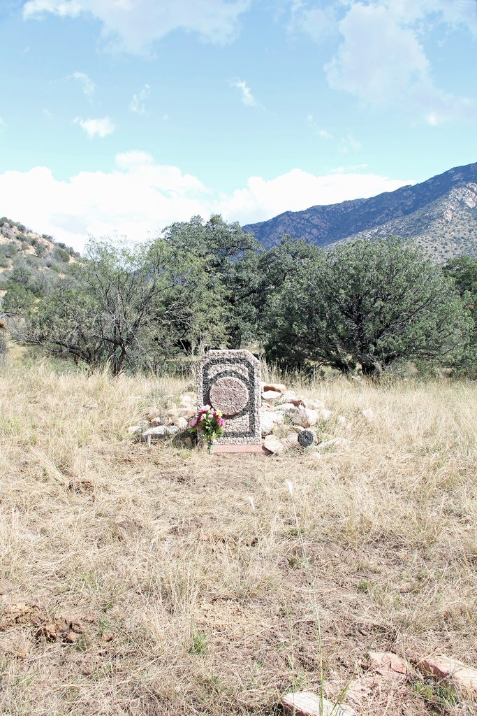
| Memorials | : | 0 |
| Location | : | Pima, Graham County, USA |
| Coordinate | : | 32.7770790, -110.0697780 |
| Description | : | From Pima, turn left onto S. Main St. In 1.5 miles, the road turns right and becomes 1200 S. In 5 miles the road “Ts”, turn right onto Spear Ranch Rd In .6 miles turn left onto W. Tripp Canyon Rd In 12.8 miles turn slight right onto Hurricane Pass Trail (at 32.776030, -110.067283) Note: This is just past a campground area where the CC camp was. There is a remaining cement foundation there. From this point on you need to walk or have a high clearance 4-wheel drive vehicle. Follow Hurricane Pass Trail to the wash -... Read More |
frequently asked questions (FAQ):
-
Where is Tripp Canyon Burial Site?
Tripp Canyon Burial Site is located at Pima, Graham County ,Arizona ,USA.
-
Tripp Canyon Burial Site cemetery's updated grave count on graveviews.com?
0 memorials
-
Where are the coordinates of the Tripp Canyon Burial Site?
Latitude: 32.7770790
Longitude: -110.0697780
Nearby Cemetories:
1. Lindsey Grave
Graham County, USA
Coordinate: 32.7327995, -110.0986023
2. Whalen Cemetery
Graham County, USA
Coordinate: 32.7167015, -110.2050018
3. Deer Creek Cemetery
Klondyke, Graham County, USA
Coordinate: 32.7166380, -110.2056840
4. Johns Cemetery
Graham County, USA
Coordinate: 32.6448020, -110.1516910
5. Kennedy Cemetery
Graham County, USA
Coordinate: 32.6408890, -110.1563610
6. Bonita Cemetery
Bonita, Graham County, USA
Coordinate: 32.5986080, -109.9819390
7. Klondyke Cemetery
Klondyke, Graham County, USA
Coordinate: 32.8292007, -110.3208008
8. Glenbar Cemetery
Glenbar, Graham County, USA
Coordinate: 32.9193993, -109.8735962
9. Pima Cemetery
Pima, Graham County, USA
Coordinate: 32.8814011, -109.8368988
10. Rogers Cemetery
Graham County, USA
Coordinate: 32.8903008, -109.8396988
11. Old Pima Cemetery
Graham County, USA
Coordinate: 32.8920860, -109.8329390
12. Ashurst Cemetery
Fort Thomas, Graham County, USA
Coordinate: 32.9944000, -109.9468994
13. Central Cemetery
Central, Graham County, USA
Coordinate: 32.8588982, -109.7992020
14. Central Cemetery Old
Central, Graham County, USA
Coordinate: 32.8564987, -109.7977982
15. Eden Cemetery
Eden, Graham County, USA
Coordinate: 32.9764260, -109.8976560
16. Thatcher Cemetery
Thatcher, Graham County, USA
Coordinate: 32.8318500, -109.7662500
17. Bryce Cemetery
Bryce, Graham County, USA
Coordinate: 32.9357986, -109.8221970
18. McEuen Cemetery
Graham County, USA
Coordinate: 33.0043983, -109.9135971
19. Fort Thomas Cemetery
Fort Thomas, Graham County, USA
Coordinate: 33.0334930, -109.9650726
20. Old Fort Thomas Cemetery
Graham County, USA
Coordinate: 33.0367012, -109.9764023
21. Bell Cemetery
Sunset, Graham County, USA
Coordinate: 32.5284730, -110.2056318
22. Hubbard Cemetery
Thatcher, Graham County, USA
Coordinate: 32.9089012, -109.7763977
23. Lebanon Cemetery
Safford, Graham County, USA
Coordinate: 32.7616997, -109.7324982
24. Hinton Cemetery
Geronimo, Graham County, USA
Coordinate: 33.0626666, -110.0446811