| Memorials | : | 0 |
| Location | : | Dry Wood, Crawford County, USA |
| Coordinate | : | 37.6618090, -94.7115040 |
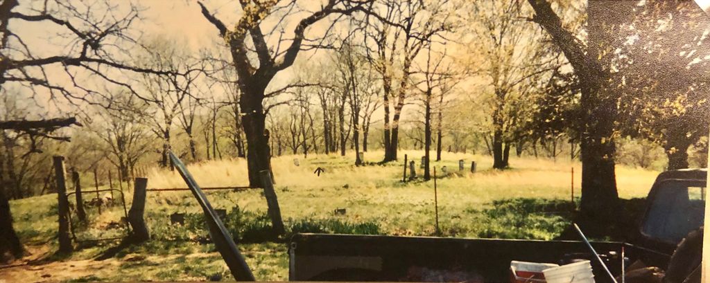
| Description | : | Trogdon Cemetery - Crawford County, Kansas Located 1 mile south of the Bourbon County line off of US Highway 69, turn west go 1 mile and then back north about 3/4 of mile on the east side of the road. This is a family cemetery on private land, no burials anymore but well cared for. It sits on the banks of Drywood Creek 1/2 mile north of what was once the town of Drywood. To get into the cemetery you have to go through a locked gate, and need permission. There are unmarked graves in this cemetery that... Read More |
frequently asked questions (FAQ):
-
Where is Trogdon Cemetery?
Trogdon Cemetery is located at Dry Wood, Crawford County ,Kansas ,USA.
-
Trogdon Cemetery cemetery's updated grave count on graveviews.com?
0 memorials
-
Where are the coordinates of the Trogdon Cemetery?
Latitude: 37.6618090
Longitude: -94.7115040
Nearby Cemetories:
1. Fowler Cemetery
Crawford County, USA
Coordinate: 37.6636009, -94.7011032
2. Brown Cemetery
Crawford County, USA
Coordinate: 37.6571999, -94.6996994
3. Nance Cemetery
Crawford County, USA
Coordinate: 37.6576300, -94.7270400
4. Howard Cemetery
Bourbon County, USA
Coordinate: 37.6741982, -94.7005997
5. Coonrod Cemetery
Crawford County, USA
Coordinate: 37.6510200, -94.7516200
6. Pleasant View Cemetery
Drywood Township, Bourbon County, USA
Coordinate: 37.6929100, -94.7385300
7. McGonigle Cemetery
Cato, Crawford County, USA
Coordinate: 37.6264000, -94.7305984
8. Endicott-Spence Cemetery
Garland, Bourbon County, USA
Coordinate: 37.6861500, -94.6673600
9. Simons Cemetery
Crawford County, USA
Coordinate: 37.6676700, -94.7800000
10. Tweedy Cemetery
Garland, Bourbon County, USA
Coordinate: 37.7097015, -94.6678009
11. Pleasant Valley Cemetery
Arcadia, Crawford County, USA
Coordinate: 37.6302480, -94.6481540
12. Mayfield Cemetery
Bourbon County, USA
Coordinate: 37.6933000, -94.6478500
13. Arcadia Catholic Cemetery
Arcadia, Crawford County, USA
Coordinate: 37.6441100, -94.6391100
14. Williams Cemetery
Crawford County, USA
Coordinate: 37.6536100, -94.7922200
15. Old Arcadia Cemetery
Arcadia, Crawford County, USA
Coordinate: 37.6539001, -94.6271973
16. Nance Farm Cemetery
Pawnee Station, Bourbon County, USA
Coordinate: 37.6833900, -94.8029400
17. Englevale Cemetery
Englevale, Crawford County, USA
Coordinate: 37.5861015, -94.7322006
18. Farlington Cemetery
Farlington, Crawford County, USA
Coordinate: 37.6255989, -94.8332977
19. Clarksburg Cemetery
Fort Scott, Bourbon County, USA
Coordinate: 37.7619019, -94.6485977
20. Leroy Cemetery
Barton County, USA
Coordinate: 37.6246986, -94.5753021
21. Martin Family Cemetery
Fort Scott, Bourbon County, USA
Coordinate: 37.7349200, -94.8277400
22. Pleasant Valley Cemetery
Hiattville, Bourbon County, USA
Coordinate: 37.7505000, -94.8144990
23. Smilie Cemetery
Mulberry, Crawford County, USA
Coordinate: 37.5503006, -94.6492004
24. Shiloh Cemetery
Liberal, Barton County, USA
Coordinate: 37.6455994, -94.5563965

