| Memorials | : | 0 |
| Location | : | Vage, Arendal kommune, Norway |
| Phone | : | 47 481 23 170 |
| Coordinate | : | 60.0405449, 5.5297505 |
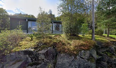
| Description | : | Våge, the largest village in Tysnes municipality, is the site of the current Tysnes Church and graveyard. It is a parish church of the Church of Norway located on the island Tysnesøya in Vestland County. The current church, a white wooden church and tower, was built in 1868 and moved in 1905. The medieval church mentioned in 1329 was replaced first in 1685 and later in 1868. The site of the old cemetery is still maintained and a wall surrounds it. Existing records begin starting in 1723 and contain records from Uggdal and Onarheim until the... Read More |
frequently asked questions (FAQ):
-
Where is Tysnes Kyrkje?
Tysnes Kyrkje is located at Grovarvegen 17 Tysnes Norway Vage, Arendal kommune ,Aust-Agder fylke , 5680Norway.
-
Tysnes Kyrkje cemetery's updated grave count on graveviews.com?
0 memorials
-
Where are the coordinates of the Tysnes Kyrkje?
Latitude: 60.0405449
Longitude: 5.5297505
Nearby Cemetories:
1. Onarheim Cemetery
Tysnes kommune, Norway
Coordinate: 59.9467600, 5.6272850
2. Vinnes Gravlund
Austevoll, Austevoll kommune, Norway
Coordinate: 60.0070170, 5.2684210
3. Ølve Cemetery
Rosendal, Kvinnherad kommune, Norway
Coordinate: 59.9928000, 5.7842000
4. Strandvik Church Cemetery
Eikelandsosen, Fusa kommune, Norway
Coordinate: 60.1593570, 5.6669040
5. Os
Osoyro, Os kommune, Norway
Coordinate: 60.1870810, 5.4701310
6. Fitjar Churchyard
Fitjar, Fitjar kommune, Norway
Coordinate: 59.9174890, 5.3191210
7. Bekkjarvik
Austevoll, Austevoll kommune, Norway
Coordinate: 60.0030320, 5.2024820
8. Fusa Kirkegaard
Eikelandsosen, Fusa kommune, Norway
Coordinate: 60.2038340, 5.6240240
9. Fusa Gamle
Eikelandsosen, Fusa kommune, Norway
Coordinate: 60.2044290, 5.6275100
10. Austevoll Cemetery
Austevoll, Austevoll kommune, Norway
Coordinate: 60.1047770, 5.1693890
11. Uskedalen
Rosendal, Kvinnherad kommune, Norway
Coordinate: 59.9313880, 5.8573680
12. Husnes Cemetery
Rosendal, Kvinnherad kommune, Norway
Coordinate: 59.8671840, 5.7586820
13. Fana Cemetery
Fanahamaren, Bergen kommune, Norway
Coordinate: 60.2632580, 5.3480710
14. Rosendal Cemetery
Bergen, Bergen kommune, Norway
Coordinate: 59.9901020, 6.0063080
15. Stord Øvre Kyrkjegard
Leirvik, Stord kommune, Norway
Coordinate: 59.7903680, 5.5108710
16. Stord Gamle Cemetery
Leirvik, Stord kommune, Norway
Coordinate: 59.7872570, 5.5098320
17. Sund Cemetery
Klokkarvik, Sund kommune, Norway
Coordinate: 60.2242423, 5.1478459
18. Eid Cemetery
Eidsvik, Kvinnherad kommune, Norway
Coordinate: 59.7872000, 5.6944000
19. Foldrøy kyrkjegard
Folderoyholmen, Bømlo kommune, Norway
Coordinate: 59.7940530, 5.2925830
20. Ovsttun Cemetery
Bergen, Bergen kommune, Norway
Coordinate: 60.3116610, 5.3624390
21. Bremnes gamle kyrkjegard
Bømlo kommune, Norway
Coordinate: 59.8014670, 5.1686310
22. Kausland Kyrkje
Kausland, Sund kommune, Norway
Coordinate: 60.2229340, 5.0488110
23. Holmedal
Rosendal, Kvinnherad kommune, Norway
Coordinate: 59.7836310, 5.9027230
24. Storetveit
Bergen, Bergen kommune, Norway
Coordinate: 60.3517580, 5.3441870

