
| Memorials | : | 1 |
| Location | : | Freestone County, USA |
| Coordinate | : | 31.5259300, -96.2676870 |
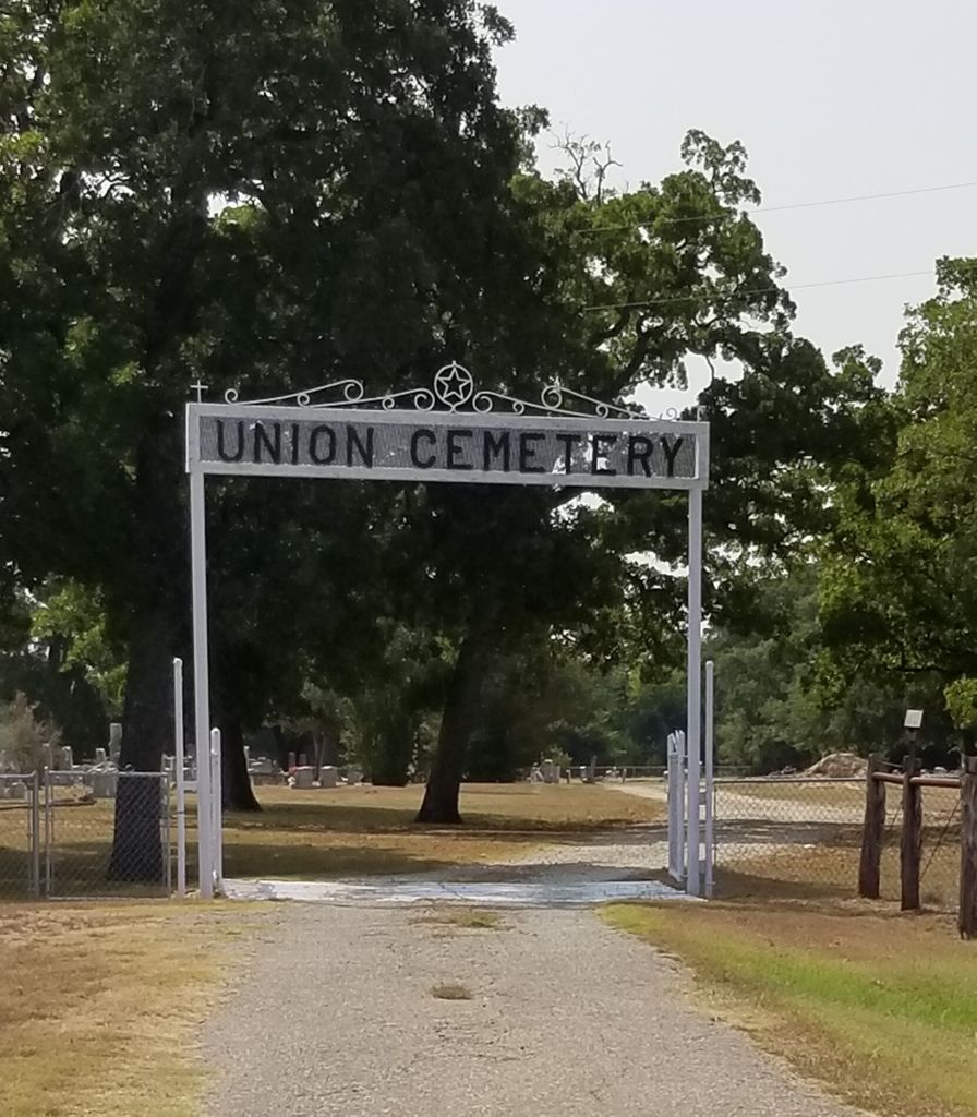
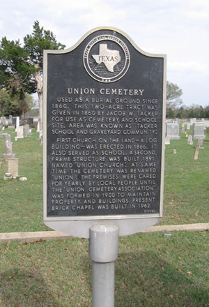
| Description | : | Directions: From Teague, take FM 80 south approximately 7 miles to FM 489, go west about 1.7 miles to Union Cemetery Road, and south about 1/2 mile to the cemetery. Historical Marker: Used as a burial ground since 1860. This two-acre tract was given in 1860 by Jacob W. Tacker for use as cemetery and school site. Area was known as "Tacker School and Graveyard Community." First church on the land-- a log building-- was erected in 1866. It also served as school. A second, frame structure was built 1891, named "Union Church." At same time the cemetery was renamed "Union."... Read More |
frequently asked questions (FAQ):
-
Where is Union Cemetery?
Union Cemetery is located at Freestone County ,Texas ,USA.
-
Union Cemetery cemetery's updated grave count on graveviews.com?
1 memorials
-
Where are the coordinates of the Union Cemetery?
Latitude: 31.5259300
Longitude: -96.2676870
Nearby Cemetories:
1. Salem Cemetery
Freestone, Freestone County, USA
Coordinate: 31.5717660, -96.2648280
2. Samford Family Cemetery
Teague, Freestone County, USA
Coordinate: 31.5475467, -96.3155775
3. Hewitt Prairie Cemetery
Freestone County, USA
Coordinate: 31.4880727, -96.2343233
4. Antioch Cemetery
Luna, Freestone County, USA
Coordinate: 31.5489090, -96.2002400
5. Philpott Cemetery
Freestone County, USA
Coordinate: 31.5697002, -96.1949997
6. Kendrick Cemetery
Freestone County, USA
Coordinate: 31.5960999, -96.2307968
7. Tirado
Donie, Freestone County, USA
Coordinate: 31.4492090, -96.2415160
8. Salem Missionary Baptist Church Cemetery
Dew, Freestone County, USA
Coordinate: 31.5758000, -96.1803000
9. Mount Canaan Cemetery
Teague, Freestone County, USA
Coordinate: 31.5927780, -96.3379110
10. Spillers Cemetery
Freestone County, USA
Coordinate: 31.4329400, -96.2657600
11. Post Oak Cemetery
Donie, Freestone County, USA
Coordinate: 31.4500008, -96.2011032
12. Greenwood Cemetery
Teague, Freestone County, USA
Coordinate: 31.6208000, -96.2966995
13. Wilson Chapel Cemetery
Donie, Freestone County, USA
Coordinate: 31.4312420, -96.2294790
14. Old Zion Cemetery
Freestone County, USA
Coordinate: 31.4689007, -96.1635971
15. Avant Prairie AME Church Cemetery
Teague, Freestone County, USA
Coordinate: 31.6088830, -96.1815780
16. Grayson Chapel Cemetery
Teague, Freestone County, USA
Coordinate: 31.6265620, -96.3254110
17. Antioch Cemetery
Teague, Freestone County, USA
Coordinate: 31.6399470, -96.2869110
18. Asia-Antioch Cemetery
Teague, Freestone County, USA
Coordinate: 31.6403008, -96.2857971
19. Varnell Cemetery
Freestone County, USA
Coordinate: 31.5280991, -96.1280975
20. Old Spring Seat Cemetery
Freestone County, USA
Coordinate: 31.4616280, -96.1478577
21. Dew Cemetery
Dew, Freestone County, USA
Coordinate: 31.5936960, -96.1410230
22. Jerusalem Cemetery
Freestone County, USA
Coordinate: 31.6329990, -96.1861750
23. Compton Cemetery
Freestone County, USA
Coordinate: 31.6039570, -96.1464770
24. Holly Grove Cemetery
Freestone County, USA
Coordinate: 31.5114002, -96.1157990