
| Memorials | : | 2 |
| Location | : | Rockwell Township, Norman County, USA |
| Coordinate | : | 47.1652778, -96.3647222 |
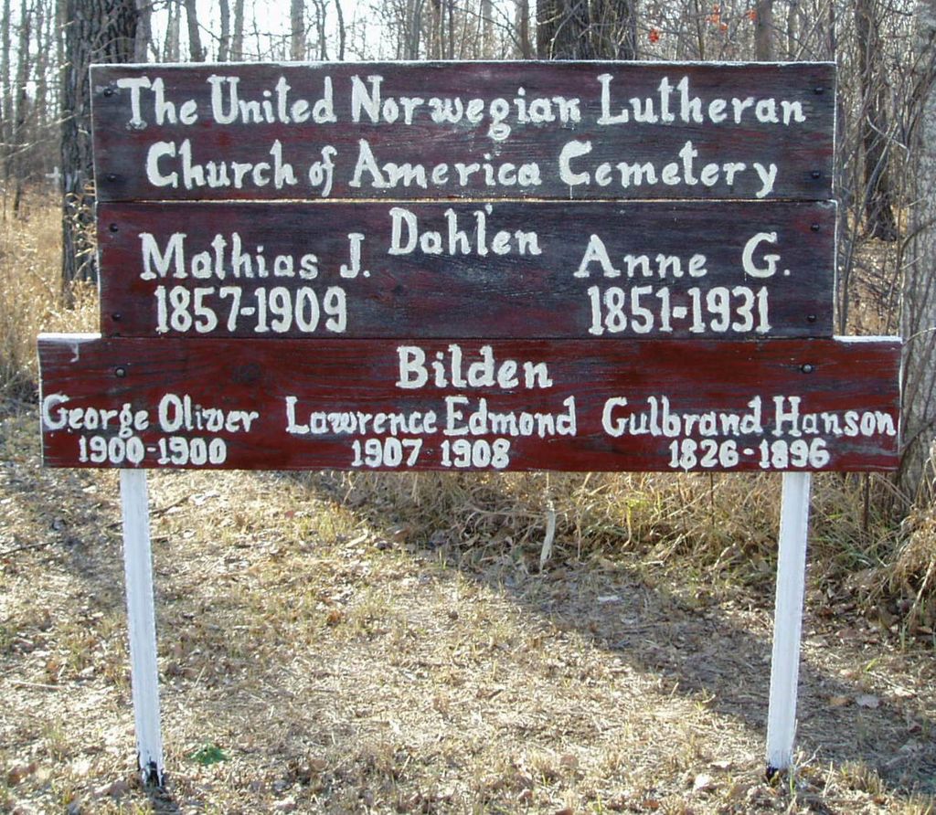
| Description | : | The United Norwegian Lutheran Church of America Cemetery or "Lost Cemetery" is 6 miles east of Borup, MN on Norman County Road 39 and 1 mile south on 330th Street. The cemetery has a few stone markers and a number of white crosses scattered through a grove of trees. The crosses mark gravesites but there are no names or dates on them. |
frequently asked questions (FAQ):
-
Where is United Norwegian Lutheran Cemetery?
United Norwegian Lutheran Cemetery is located at Rockwell Township, Norman County ,Minnesota ,USA.
-
United Norwegian Lutheran Cemetery cemetery's updated grave count on graveviews.com?
2 memorials
-
Where are the coordinates of the United Norwegian Lutheran Cemetery?
Latitude: 47.1652778
Longitude: -96.3647222
Nearby Cemetories:
1. Old Jevnaker Cemetery
Hagen Township, Clay County, USA
Coordinate: 47.1441710, -96.3515780
2. Jevnaker Cemetery
Rockwell Township, Norman County, USA
Coordinate: 47.1514015, -96.3953018
3. Syre Cemetery
Syre, Norman County, USA
Coordinate: 47.1869090, -96.2592670
4. Winchester Cemetery
Borup, Norman County, USA
Coordinate: 47.1810989, -96.5006027
5. Sliper Cemetery
Ulen Township, Clay County, USA
Coordinate: 47.0931015, -96.2656021
6. Skandinavia Cemetery
McDonaldsville Township, Norman County, USA
Coordinate: 47.2522011, -96.4360962
7. Norman County Cemetery
Lake Ida Township, Norman County, USA
Coordinate: 47.2660380, -96.3849880
8. West Wild Rice Cemetery
Lake Ida Township, Norman County, USA
Coordinate: 47.2667007, -96.3846970
9. Bethlehem Memorial Cemetery
Ulen Township, Clay County, USA
Coordinate: 47.0915900, -96.2588000
10. Calvary Lutheran Cemetery
Ulen Township, Clay County, USA
Coordinate: 47.0907100, -96.2587100
11. Bethlehem Lutheran West Cemetery
Ulen Township, Clay County, USA
Coordinate: 47.0783600, -96.2803800
12. Bethel Swedish Cemetery
Wild Rice Township, Norman County, USA
Coordinate: 47.2659870, -96.3116980
13. Creamery Cemetery
Ulen, Clay County, USA
Coordinate: 47.0785820, -96.2587730
14. Zion Cemetery
Twin Valley, Norman County, USA
Coordinate: 47.2566986, -96.2630997
15. Saint William Catholic Cemetery
Twin Valley, Norman County, USA
Coordinate: 47.2573318, -96.2636642
16. Keene Lutheran Cemetery
Keene Township, Clay County, USA
Coordinate: 47.0354400, -96.3650300
17. Immanuel Lutheran Cemetery
Flom Township, Norman County, USA
Coordinate: 47.1894455, -96.1725006
18. Trinity Cemetery
Wild Rice Township, Norman County, USA
Coordinate: 47.2877998, -96.2771988
19. Felton Cemetery
Felton Township, Clay County, USA
Coordinate: 47.0643997, -96.4993973
20. East Wild Rice Lutheran Cemetery
Flom Township, Norman County, USA
Coordinate: 47.2244200, -96.1742980
21. Walworth Baptist Cemetery
Walworth Township, Becker County, USA
Coordinate: 47.1404600, -96.1517000
22. Aspelund Lutheran Church Cemetery
Flom Township, Norman County, USA
Coordinate: 47.1574300, -96.1315480
23. Ada Cemetery
Ada, Norman County, USA
Coordinate: 47.2952050, -96.5013380
24. Old Aspelund Church Cemetery
Flom Township, Norman County, USA
Coordinate: 47.1519610, -96.1300710