
| Memorials | : | 2 |
| Location | : | Tallahassee, Leon County, USA |
| Coordinate | : | 30.3801360, -84.1632290 |
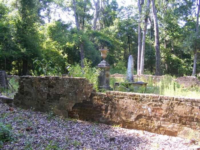
| Description | : | Verdura Plantation Cemetery is located off of Tram Road in Leon County. The land is owned by the St. Joseph Company and is private. The cemetery graves have been neglected, vandalized and desecrated. This is NOT the "Chaires Family Cemetery" on Old Dirt Road. That Cemetery should posted as "Green Hill Chaires Family Cemetery". |
frequently asked questions (FAQ):
-
Where is Verdura Plantation Cemetery?
Verdura Plantation Cemetery is located at Tram Road (County Road 259) Tallahassee, Leon County ,Florida , 32311USA.
-
Verdura Plantation Cemetery cemetery's updated grave count on graveviews.com?
2 memorials
-
Where are the coordinates of the Verdura Plantation Cemetery?
Latitude: 30.3801360
Longitude: -84.1632290
Nearby Cemetories:
1. Southwood Plantation Cemetery
Tallahassee, Leon County, USA
Coordinate: 30.3893800, -84.2099300
2. Mount Sinai Cemetery
Tallahassee, Leon County, USA
Coordinate: 30.4228190, -84.1806610
3. Connie Copeland African-American Cemetery
Tallahassee, Leon County, USA
Coordinate: 30.3838760, -84.2184020
4. Kilpatrick Cemetery
Tallahassee, Leon County, USA
Coordinate: 30.4054460, -84.2120160
5. Tallahassee National Cemetery
Tallahassee, Leon County, USA
Coordinate: 30.4255500, -84.1867700
6. Thomas Peter Chaires Cemetery
Chaires, Leon County, USA
Coordinate: 30.4169290, -84.1212420
7. Kelley Cemetery
Woodville, Leon County, USA
Coordinate: 30.3211002, -84.1675034
8. Saint Paul AME Church Cemetery
Chaires, Leon County, USA
Coordinate: 30.4343150, -84.1209690
9. Chaires Family Cemetery
Tallahassee, Leon County, USA
Coordinate: 30.4425230, -84.1334830
10. Gopher Ridge Cemetery
Chaires, Leon County, USA
Coordinate: 30.4478500, -84.1490800
11. Mount Pisgah AME Church Cemetery
Tallahassee, Leon County, USA
Coordinate: 30.3837550, -84.2436630
12. Green Hill Chaires Cemetery
Tallahassee, Leon County, USA
Coordinate: 30.4481000, -84.1452100
13. DeSoto Field Cemetery
Leon County, USA
Coordinate: 30.4125004, -84.2352982
14. Skipper Cemetery
Chaires, Leon County, USA
Coordinate: 30.4202995, -84.0916977
15. Rhodes Family Cemetery
Leon County, USA
Coordinate: 30.3319640, -84.2298100
16. East Grove Cemetery
Woodville, Leon County, USA
Coordinate: 30.3415210, -84.2477890
17. McDaniel Cemetery
Woodville, Leon County, USA
Coordinate: 30.3072055, -84.2108332
18. Tom Brown Park Cemetery
Tallahassee, Leon County, USA
Coordinate: 30.4507730, -84.2167850
19. Capitola Cemetery
Capitola, Leon County, USA
Coordinate: 30.4437090, -84.0840610
20. Belair Cemetery
Leon County, USA
Coordinate: 30.3806130, -84.2744360
21. Cody Pentecostal Holiness Church Cemetery
Jefferson County, USA
Coordinate: 30.3621680, -84.0537350
22. Woodville Cemetery
Woodville, Leon County, USA
Coordinate: 30.3152590, -84.2455580
23. Perkins Cemetery
Perkins, Leon County, USA
Coordinate: 30.4638806, -84.2221667
24. Munree Cemetery
Tallahassee, Leon County, USA
Coordinate: 30.4746420, -84.1933520