
| Memorials | : | 0 |
| Location | : | Zandhoven, Arrondissement Antwerpen, Belgium |
| Coordinate | : | 51.1872400, 4.6491700 |
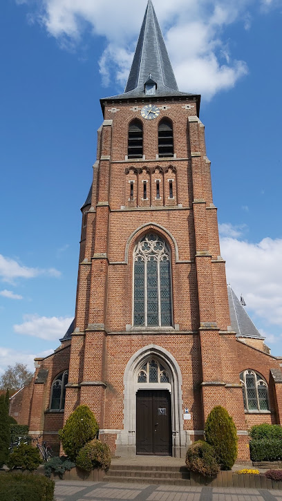
| Description | : | Location Information: The village of Viersel is located east of the town of Antwerp off the E34/E313/A13 which runs between Antwerp and Luik, driving from Antwerp follow the E34 to the junction with the E313, then follow the E313 direction Luik. Turn off at junction 19 Massenhoven, at the T junction turn left on the N14 direction Lier. After a short distance along the N14 take the first turning on the left signed for Viersel, this road is called Herentalsebaan, on entering the village take the first turning on the right called Parochiestraat and the church is a short way... Read More |
frequently asked questions (FAQ):
-
Where is Viersel Churchyard?
Viersel Churchyard is located at Zandhoven, Arrondissement Antwerpen ,Antwerp (Antwerpen) ,Belgium.
-
Viersel Churchyard cemetery's updated grave count on graveviews.com?
0 memorials
-
Where are the coordinates of the Viersel Churchyard?
Latitude: 51.1872400
Longitude: 4.6491700
Nearby Cemetories:
1. Nijlen Communal Cemetery
Nijlen, Arrondissement Mechelen, Belgium
Coordinate: 51.1667600, 4.6693300
2. Emblem Cemetery
Ranst, Arrondissement Antwerpen, Belgium
Coordinate: 51.1608300, 4.6022600
3. Oelegem Cemetery
Ranst, Arrondissement Antwerpen, Belgium
Coordinate: 51.2101053, 4.5962416
4. Pulle Begraafplaats
Pulle, Arrondissement Antwerpen, Belgium
Coordinate: 51.2033104, 4.7154594
5. Comunal cemetery Kessel
Kessel, Arrondissement Mechelen, Belgium
Coordinate: 51.1419228, 4.6379339
6. Halle-Zoersel Communal Cemetery
Zoersel, Arrondissement Antwerpen, Belgium
Coordinate: 51.2390400, 4.6495200
7. Lier Kloosterheide Cemetery
Lier, Arrondissement Mechelen, Belgium
Coordinate: 51.1403100, 4.5964400
8. Schilde Cemetery
Schilde, Arrondissement Antwerpen, Belgium
Coordinate: 51.2314200, 4.5829500
9. Bouwel Communal Cemetery
Grobbendonk, Arrondissement Turnhout, Belgium
Coordinate: 51.1697500, 4.7428200
10. Vorselaar Communal Cemetery
Vorselaar, Arrondissement Turnhout, Belgium
Coordinate: 51.2050700, 4.7700800
11. Sint-Pieterskerk
Vorselaar, Arrondissement Turnhout, Belgium
Coordinate: 51.2025400, 4.7710400
12. Herenthout Gemeentelijke Begraafplaats
Herenthout, Arrondissement Turnhout, Belgium
Coordinate: 51.1392600, 4.7514500
13. Lier Mechelsepoort Cemetery
Lier, Arrondissement Mechelen, Belgium
Coordinate: 51.1284700, 4.5585800
14. Wijnegem Communal Cemetery
Wijnegem, Arrondissement Antwerpen, Belgium
Coordinate: 51.2282900, 4.5263600
15. Lier Belgian Military Cemetery
Lier, Arrondissement Mechelen, Belgium
Coordinate: 51.1239400, 4.5493700
16. Zoersel Churchyard
Zoersel, Arrondissement Antwerpen, Belgium
Coordinate: 51.2671200, 4.7120900
17. Koningshooikt Cemetery
Lier, Arrondissement Mechelen, Belgium
Coordinate: 51.0990500, 4.6049200
18. Sint-Antonius Begraafplaats
Zoersel, Arrondissement Antwerpen, Belgium
Coordinate: 51.2816500, 4.6295100
19. 's Gravenwezel Cemetery
Schilde, Arrondissement Antwerpen, Belgium
Coordinate: 51.2694400, 4.5603300
20. Borsbeek Cemetery
Borsbeek, Arrondissement Antwerpen, Belgium
Coordinate: 51.1939200, 4.4812300
21. Deurne Ruggeveld Cemetery
Antwerp, Arrondissement Antwerpen, Belgium
Coordinate: 51.2192021, 4.4857160
22. Boechout Cemetery
Boechout, Arrondissement Antwerpen, Belgium
Coordinate: 51.1552050, 4.4838810
23. Deurne Silsburg Cemetery
Antwerp, Arrondissement Antwerpen, Belgium
Coordinate: 51.2044370, 4.4772290
24. Lint Cemetery
Lint, Arrondissement Antwerpen, Belgium
Coordinate: 51.1223680, 4.5061110