
| Memorials | : | 0 |
| Location | : | Kingwood, Preston County, USA |
| Coordinate | : | 39.4645800, -79.6809400 |
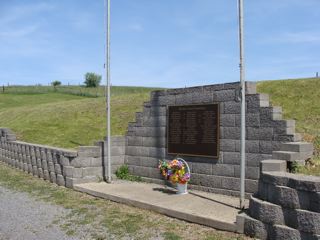
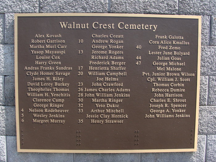
| Description | : | May also be known as County Home Cemetery. It is believed that there are some individuals buried here whose names do not appear on the plaque because some of the graves were not necessarily marked or the original markers were missing/destroyed. GPS coordinates: N39.46458 W-79.68094 |
frequently asked questions (FAQ):
-
Where is Walnut Crest Cemetery?
Walnut Crest Cemetery is located at Kingwood, Preston County ,West Virginia ,USA.
-
Walnut Crest Cemetery cemetery's updated grave count on graveviews.com?
0 memorials
-
Where are the coordinates of the Walnut Crest Cemetery?
Latitude: 39.4645800
Longitude: -79.6809400
Nearby Cemetories:
1. Maplewood Cemetery
Kingwood, Preston County, USA
Coordinate: 39.4686012, -79.6819000
2. Trowbridge Cemetery
Kingwood, Preston County, USA
Coordinate: 39.4844670, -79.6607570
3. Wilson Cemetery
Kingwood, Preston County, USA
Coordinate: 39.4380989, -79.6650009
4. Shrout Cemetery
Pleasantdale, Preston County, USA
Coordinate: 39.4977460, -79.6769662
5. Irona Cemetery
Irona, Preston County, USA
Coordinate: 39.4497660, -79.7218390
6. Whetsell-Felton Cemetery
Kingwood, Preston County, USA
Coordinate: 39.4314450, -79.6520520
7. Sunset Memorial Gardens
Kingwood, Preston County, USA
Coordinate: 39.4820880, -79.7291230
8. Albright Cemetery
Preston County, USA
Coordinate: 39.4949500, -79.6436260
9. White Family Cemetery
Pleasantdale, Preston County, USA
Coordinate: 39.5057450, -79.6908330
10. Saint Joe Cemetery
Albright, Preston County, USA
Coordinate: 39.4894510, -79.6320840
11. Shay and Elliott Cemetery
Pleasantdale, Preston County, USA
Coordinate: 39.5142731, -79.6711174
12. Pleasantdale Cemetery
Pleasantdale, Preston County, USA
Coordinate: 39.5179330, -79.6810740
13. Pell Cemetery
Kingwood, Preston County, USA
Coordinate: 39.5179330, -79.6810740
14. Saint Joseph Catholic Cemetery
Howesville, Preston County, USA
Coordinate: 39.4507080, -79.7496300
15. Rhodes Cemetery
Howesville, Preston County, USA
Coordinate: 39.4337550, -79.7427880
16. Sypolt
Albright, Preston County, USA
Coordinate: 39.4910030, -79.6085490
17. Sypolt Cemetery #2
Albright, Preston County, USA
Coordinate: 39.4910030, -79.6085490
18. Sypolt Cemetery
Albright, Preston County, USA
Coordinate: 39.4907410, -79.6059890
19. Howesville United Methodist Church Cemetery
Howesville, Preston County, USA
Coordinate: 39.4332085, -79.7604828
20. Wesley Chapel Cemetery
Pleasantdale, Preston County, USA
Coordinate: 39.5260600, -79.7239100
21. Shaw Cemetery
Albright, Preston County, USA
Coordinate: 39.5221760, -79.6277860
22. Snyder Cemetery
Blaser, Preston County, USA
Coordinate: 39.3993988, -79.7174988
23. Beech Run Cemetery
Preston County, USA
Coordinate: 39.5452995, -79.6641998
24. Bethlehem Cemetery
Reedsville, Preston County, USA
Coordinate: 39.4817740, -79.7855120