
| Memorials | : | 0 |
| Location | : | Rome, Floyd County, USA |
| Coordinate | : | 34.1669006, -85.1964035 |
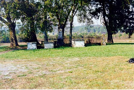
| Description | : | The Ware Family Cemetery is located on what was Edward and Sarah Daniel Penn Ware's plantation, Courtesy, consisting of 1200 acres. Please see biography of Edward Ware for further information. The survey of interments in the Ware Family Cemetery, Six Mile, Floyd County, Georgia was taken in November of 1991 by Bob Anderson, A Southern States Historic Resource and Landmark Research Project, Rome, Georgia. Bob Anderson was very instrumental in furthering the Ware genealogical research and was generous in sharing his research and expertise to many Wares. The survey was taken after a very patient reconstruction... Read More |
frequently asked questions (FAQ):
-
Where is Ware Cemetery?
Ware Cemetery is located at Rome, Floyd County ,Georgia ,USA.
-
Ware Cemetery cemetery's updated grave count on graveviews.com?
0 memorials
-
Where are the coordinates of the Ware Cemetery?
Latitude: 34.1669006
Longitude: -85.1964035
Nearby Cemetories:
1. Six Mile Cemetery
Floyd County, USA
Coordinate: 34.1741982, -85.2114029
2. Vanns Valley Cemetery
Rome, Floyd County, USA
Coordinate: 34.1796989, -85.2071991
3. Bobo Cemetery
Floyd County, USA
Coordinate: 34.1577988, -85.2136002
4. Birdsong Cemetery
Floyd County, USA
Coordinate: 34.1688995, -85.2217026
5. Holy Ground Church Cemetery
Six Mile, Floyd County, USA
Coordinate: 34.1876040, -85.2030930
6. Rome Memorial Park South
Rome, Floyd County, USA
Coordinate: 34.1906770, -85.2023350
7. Lindale Cemetery
Lindale, Floyd County, USA
Coordinate: 34.1802400, -85.1711900
8. Silver Creek Cemetery
Rome, Floyd County, USA
Coordinate: 34.1763992, -85.1624985
9. New Bethel Cemetery
Floyd County, USA
Coordinate: 34.1399994, -85.1753006
10. Damascus Cemetery
Silver Creek, Floyd County, USA
Coordinate: 34.1408005, -85.1663971
11. Saint Pauls Cemetery
Rome, Floyd County, USA
Coordinate: 34.1885986, -85.1436005
12. Blacks Bluff Cemetery
Rome, Floyd County, USA
Coordinate: 34.2192900, -85.1995000
13. Pleasant Hill Cemetery
Floyd County, USA
Coordinate: 34.1147003, -85.2089005
14. Free Liberty Cemetery
Floyd County, USA
Coordinate: 34.1660995, -85.2699966
15. Pleasant Hope Cemetery
Rome, Floyd County, USA
Coordinate: 34.1258011, -85.1382980
16. Montgomery Cemetery
Floyd County, USA
Coordinate: 34.1535988, -85.2739029
17. Mountain View Cemetery
Floyd County, USA
Coordinate: 34.1791992, -85.2763977
18. New Prospect Cemetery
Floyd County, USA
Coordinate: 34.1119003, -85.2472000
19. Old Eastview Cemetery
Rome, Floyd County, USA
Coordinate: 34.2341400, -85.1573800
20. Old Antioch Cemetery
Floyd County, USA
Coordinate: 34.2341995, -85.1530991
21. Bush Arbor Baptist Church Cemetery
Rome, Floyd County, USA
Coordinate: 34.1949997, -85.2822037
22. Floyd Memory Gardens
Rome, Floyd County, USA
Coordinate: 34.2186012, -85.1268997
23. Shadyside Cemetery
Rome, Floyd County, USA
Coordinate: 34.2444000, -85.1885986
24. Rodeph Sholom Cemetery
Rome, Floyd County, USA
Coordinate: 34.2442017, -85.1774979