
| Memorials | : | 0 |
| Location | : | Akron, Summit County, USA |
| Coordinate | : | 41.0695100, -81.4627300 |
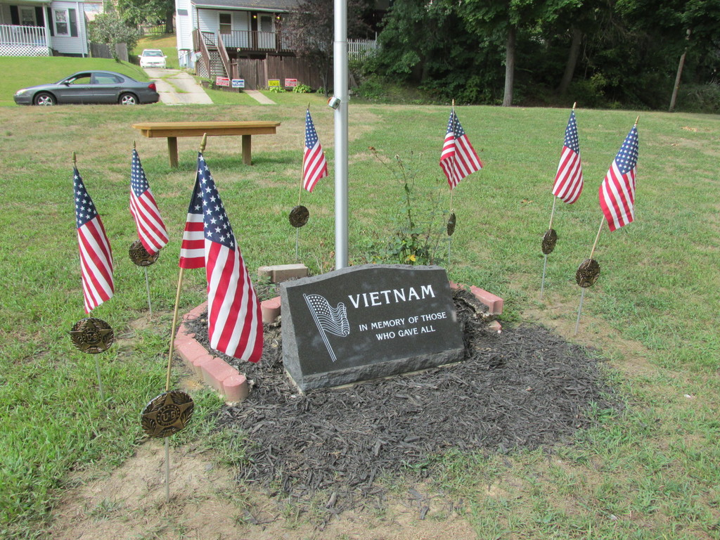
| Description | : | A small triangle of land in Goodyear Heights, bordered by Watson St., Malasia Rd. and Wingfoot Way. Contains eight memorials (cenotaphs) commemorating 12 local men who died in Vietnam. Several memorials are arranged in each corner of the triangle. A tree was planted in the triangle for each memorial; some of the trees still stand. Sadly, three additional memorials originally placed there are missing their plaques. |
frequently asked questions (FAQ):
-
Where is Watson Park Vietnam Memory Garden?
Watson Park Vietnam Memory Garden is located at Corner ofWatson and Malasia Akron, Summit County ,Ohio , 44305USA.
-
Watson Park Vietnam Memory Garden cemetery's updated grave count on graveviews.com?
0 memorials
-
Where are the coordinates of the Watson Park Vietnam Memory Garden?
Latitude: 41.0695100
Longitude: -81.4627300
Nearby Cemetories:
1. Middlebury Cemetery
Akron, Summit County, USA
Coordinate: 41.0733986, -81.4784012
2. East Akron Cemetery
Akron, Summit County, USA
Coordinate: 41.0681000, -81.4805984
3. Old Springfield Cemetery
Akron, Summit County, USA
Coordinate: 41.0501780, -81.4722920
4. Memory Lane Cemetery
Ellet, Summit County, USA
Coordinate: 41.0495140, -81.4416990
5. Boosinger Cemetery
Tallmadge, Summit County, USA
Coordinate: 41.0677700, -81.4250000
6. Ellet Cemetery
Akron, Summit County, USA
Coordinate: 41.0452995, -81.4360962
7. Infirmary Cemetery
Tallmadge, Summit County, USA
Coordinate: 41.1003340, -81.4492790
8. Tallmadge Cemetery
Tallmadge, Summit County, USA
Coordinate: 41.0989990, -81.4420013
9. First Congregational Churchyard
Tallmadge, Summit County, USA
Coordinate: 41.1018880, -81.4412870
10. Spicer Cemetery (Defunct)
Akron, Summit County, USA
Coordinate: 41.0758018, -81.5108032
11. Bettes Cemetery
Akron, Summit County, USA
Coordinate: 41.1029950, -81.4851020
12. Grace Park Memorial
Akron, Summit County, USA
Coordinate: 41.0838500, -81.5094400
13. Grace Cathedral Cemetery
Akron, Summit County, USA
Coordinate: 41.0361958, -81.4297615
14. Hillside Memorial Park
Akron, Summit County, USA
Coordinate: 41.0387001, -81.4255981
15. Old Dublin Cemetery
Akron, Summit County, USA
Coordinate: 41.0813904, -81.5191727
16. Maple Hill Cemetery
Akron, Summit County, USA
Coordinate: 41.0416527, -81.4056473
17. Greenwood Cemetery
Mogadore, Summit County, USA
Coordinate: 41.0518990, -81.3983002
18. Glendale Cemetery
Akron, Summit County, USA
Coordinate: 41.0847015, -81.5282974
19. Mount Hope Cemetery
Akron, Summit County, USA
Coordinate: 41.0490990, -81.5266037
20. Saint Bernards Cemetery
Akron, Summit County, USA
Coordinate: 41.0848198, -81.5315170
21. Slovak Evangelical Cemetery
Krumroy, Summit County, USA
Coordinate: 41.0131989, -81.4675980
22. Edwin Shaw Sanitarium Cemetery
South Akron, Summit County, USA
Coordinate: 41.0162010, -81.4332962
23. South Street Jewish Cemetery
Akron, Summit County, USA
Coordinate: 41.0612790, -81.5401000
24. Mount Peace Cemetery
Akron, Summit County, USA
Coordinate: 41.0970993, -81.5322037