
| Memorials | : | 0 |
| Location | : | Holberrow Green, Wychavon District, England |
| Website | : | www.westallpark.co.uk/ |
| Coordinate | : | 52.2400246, -1.9540930 |
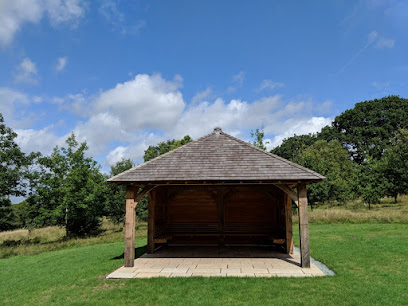
| Description | : | Westall Park aim to create a place which those who wish to remember their loved ones will want to visit, not out of a sense of duty, but from the pleasure and peace of mind it can evoke. Westall Park is a green, environmentally friendly burial ground for quiet reflection, in an informal setting amongst trees, wild flowers and wildlife. Set in one of the most attractive locations of any woodland burial in the country, Westall Park is located midway between Worcester and Stratford-upon-Avon, near the village of Inkberrow and is approached via a landscaped entrance and a quarter mile private... Read More |
frequently asked questions (FAQ):
-
Where is Westall Park Natural Burial Ground?
Westall Park Natural Burial Ground is located at Holberrow Green, Wychavon District ,Worcestershire , B96 6JYEngland.
-
Westall Park Natural Burial Ground cemetery's updated grave count on graveviews.com?
0 memorials
-
Where are the coordinates of the Westall Park Natural Burial Ground?
Latitude: 52.2400246
Longitude: -1.9540930
Nearby Cemetories:
1. Westhall Park Burial Ground
Redditch Borough, England
Coordinate: 52.2361250, -1.9531880
2. Edgioake Cemetery
Redditch, Redditch Borough, England
Coordinate: 52.2490540, -1.9416430
3. Astwood Bank Cemetery
Bromsgrove, Bromsgrove District, England
Coordinate: 52.2493950, -1.9415010
4. St. Paul's Churchyard
Cookhill, Wychavon District, England
Coordinate: 52.2288000, -1.9221900
5. St John the Baptist Churchyard
Feckenham, Redditch Borough, England
Coordinate: 52.2529220, -1.9883970
6. Cookhill Baptist Church
Cookhill, Wychavon District, England
Coordinate: 52.2212600, -1.9201600
7. St Peters Churchyard
Inkberrow, Wychavon District, England
Coordinate: 52.2130900, -1.9778400
8. Cookhill Priory
Cookhill, Wychavon District, England
Coordinate: 52.2136500, -1.9229000
9. St.John the Baptist Churchyard
Bradley Green, Wychavon District, England
Coordinate: 52.2402900, -2.0217000
10. St. Peter's Chapel Graveyard
Coughton, Stratford-on-Avon District, England
Coordinate: 52.2419055, -1.8859665
11. St Peter Churchyard
Coughton, Stratford-on-Avon District, England
Coordinate: 52.2431270, -1.8792580
12. St Nicholas Churchyard
Dormston, Wychavon District, England
Coordinate: 52.2164000, -2.0201100
13. St. Peter's Churchyard
Abbots Morton, Wychavon District, England
Coordinate: 52.1929700, -1.9622700
14. St. Mary's Roman Catholic Churchyard
Studley, Stratford-on-Avon District, England
Coordinate: 52.2691341, -1.8925916
15. Nativity of the Blessed Virgin Mary Churchyard
Studley, Stratford-on-Avon District, England
Coordinate: 52.2693200, -1.8925800
16. St James Churchyard
Weethley, Stratford-on-Avon District, England
Coordinate: 52.1961000, -1.9208200
17. St. Leonard's Churchyard
Spernall, Stratford-on-Avon District, England
Coordinate: 52.2572200, -1.8748400
18. Stock Green Baptist Chapel
Stock Green, Wychavon District, England
Coordinate: 52.2241900, -2.0349000
19. The Old Cemetery
Alcester, Stratford-on-Avon District, England
Coordinate: 52.2173140, -1.8747110
20. St. James Churchyard
Kington, Wychavon District, England
Coordinate: 52.2011700, -2.0155300
21. Holy Trinity Churchyard
Arrow, Stratford-on-Avon District, England
Coordinate: 52.2065300, -1.8812400
22. St Nicholas Churchyard
Alcester, Stratford-on-Avon District, England
Coordinate: 52.2154240, -1.8688930
23. Former Baptist Church
Alcester, Stratford-on-Avon District, England
Coordinate: 52.2157280, -1.8674960
24. Redditch Congregational Church Churchyard
Redditch, Redditch Borough, England
Coordinate: 52.3029110, -1.9423500