
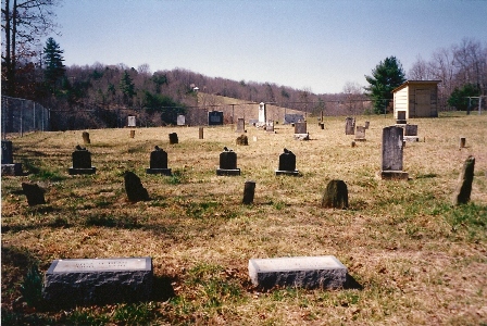
| Memorials | : | 19 |
| Location | : | Cana, Carroll County, USA |
| Coordinate | : | 36.5850100, -80.6461990 |
frequently asked questions (FAQ):
-
Where is Westmoreland Cemetery?
Westmoreland Cemetery is located at Pheasant Ridge Road (Rt. 995) Cana, Carroll County ,Virginia , 24317USA.
-
Westmoreland Cemetery cemetery's updated grave count on graveviews.com?
19 memorials
-
Where are the coordinates of the Westmoreland Cemetery?
Latitude: 36.5850100
Longitude: -80.6461990
Nearby Cemetories:
1. A.L. Jones Family Cemetery
Cana, Carroll County, USA
Coordinate: 36.5754410, -80.6561640
2. Speas Family Cemetery
Cana, Carroll County, USA
Coordinate: 36.5724564, -80.6447983
3. Epworth United Methodist Church Cemetery
Cana, Carroll County, USA
Coordinate: 36.5736110, -80.6536110
4. Flat Ridge Baptist Church Cemetery
Cana, Carroll County, USA
Coordinate: 36.5867470, -80.6298910
5. Solid Rock Baptist Church Cemetery
Cana, Carroll County, USA
Coordinate: 36.5652400, -80.6357650
6. Glass Family Memorial Cemetery
Cana, Carroll County, USA
Coordinate: 36.5652280, -80.6357090
7. Cana Baptist Church Cemetery
Cana, Carroll County, USA
Coordinate: 36.5920764, -80.6717347
8. Primitive Baptist Church Of Jesus Christ Cemetery
Cana, Carroll County, USA
Coordinate: 36.5917320, -80.6737210
9. Wisler Cemetery
Cana, Carroll County, USA
Coordinate: 36.5933240, -80.6756550
10. Mount Bethel Moravian Graveyard
Cana, Carroll County, USA
Coordinate: 36.6053120, -80.6272700
11. Oak Ridge Baptist Church Cemetery
Cana, Carroll County, USA
Coordinate: 36.5718760, -80.6800790
12. Allen Cemetery
Cana, Carroll County, USA
Coordinate: 36.6155280, -80.6192210
13. State Line Primitive Baptist Church Cemetery
Mount Airy, Surry County, USA
Coordinate: 36.5580000, -80.6117220
14. Rocky Ford Christian Church Cemetery
Cana, Carroll County, USA
Coordinate: 36.6080580, -80.6857110
15. Harrold Cemetery
Carroll County, USA
Coordinate: 36.6199300, -80.6219970
16. Mount Carmel Baptist Church Cemetery
Mount Airy, Surry County, USA
Coordinate: 36.5432510, -80.6457214
17. Leftwich Family Cemetery
Cana, Carroll County, USA
Coordinate: 36.6211110, -80.6758350
18. Christopher W Jones Cemetery
Cana, Carroll County, USA
Coordinate: 36.5819178, -80.7000292
19. Bear Trail Baptist Church Cemetery
Cana, Carroll County, USA
Coordinate: 36.6263910, -80.6655010
20. Edwards Cemetery
Cana, Carroll County, USA
Coordinate: 36.6154480, -80.6904890
21. Gray Cemetery
Cana, Carroll County, USA
Coordinate: 36.5943420, -80.7034040
22. Pauls Creek Baptist Church Cemetery
Cana, Carroll County, USA
Coordinate: 36.6072870, -80.6976360
23. Rigney Family Cemetery
Cana, Carroll County, USA
Coordinate: 36.6233650, -80.6806990
24. Thomas Cemetery
Fancy Gap, Carroll County, USA
Coordinate: 36.6312940, -80.6592180