
| Memorials | : | 0 |
| Location | : | Golden, Jefferson County, USA |
| Coordinate | : | 39.7517430, -105.2276090 |
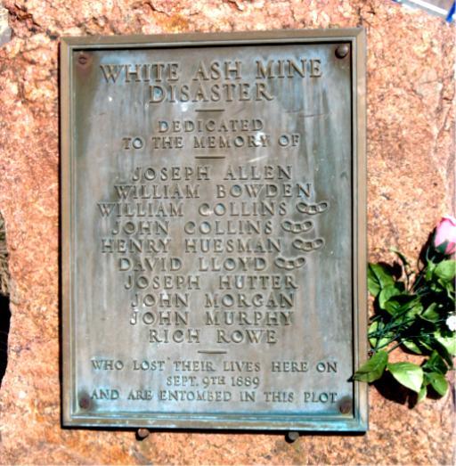
| Description | : | In 1889, a mine collapse allowed water in an adjacent abandoned and flooded mine to rush into the White Ash mine, drowning the 10 men working in this mine. The mine was closed and abandoned following the flood, entombing the bodies. The White Ash coal mine extended underground from what is now the athletic fields of the Colorado School of Mines northward to a point about 1 mile north of Clear Creek. A red granite marker commemorates the site of the White Ash Mine disaster. Source: U.S. Geologic Survey |
frequently asked questions (FAQ):
-
Where is White Ash Mine Memorial?
White Ash Mine Memorial is located at Birch Street Golden, Jefferson County ,Colorado , 80401USA.
-
White Ash Mine Memorial cemetery's updated grave count on graveviews.com?
0 memorials
-
Where are the coordinates of the White Ash Mine Memorial?
Latitude: 39.7517430
Longitude: -105.2276090
Nearby Cemetories:
1. Calvary Episcopal Church Columbarium
Golden, Jefferson County, USA
Coordinate: 39.7539291, -105.2214203
2. Old Golden City Cemetery
Golden, Jefferson County, USA
Coordinate: 39.7637210, -105.2275040
3. William Williams Memorial
Golden, Jefferson County, USA
Coordinate: 39.7338900, -105.2390590
4. Buffalo Bill Memorial Museum
Golden, Jefferson County, USA
Coordinate: 39.7332993, -105.2388763
5. Golden Cemetery
Golden, Jefferson County, USA
Coordinate: 39.7280617, -105.1961136
6. Community Hall Rockland Cemetery
Jefferson County, USA
Coordinate: 39.7097015, -105.2722015
7. Rockland Cemetery
Golden, Jefferson County, USA
Coordinate: 39.7095261, -105.2728348
8. Moundview Cemetery
Mount Vernon Club Place, Jefferson County, USA
Coordinate: 39.7227783, -105.2933273
9. Mount Vernon Cemetery
Golden, Jefferson County, USA
Coordinate: 39.6910000, -105.2090000
10. Mount Olivet Catholic Cemetery
Wheat Ridge, Jefferson County, USA
Coordinate: 39.7832985, -105.1477966
11. Golden Hill Cemetery
Lakewood, Jefferson County, USA
Coordinate: 39.7392006, -105.1346970
12. Glory of God Lutheran Church Columbarium
Wheat Ridge, Jefferson County, USA
Coordinate: 39.7680000, -105.1352000
13. Green Mountain United Methodist Church Columbarium
Lakewood, Jefferson County, USA
Coordinate: 39.7126260, -105.1419500
14. Shepherd of The Hills Presbyterian Church Cemetery
Lakewood, Jefferson County, USA
Coordinate: 39.7472000, -105.1278000
15. Ralston Cemetery
Arvada, Jefferson County, USA
Coordinate: 39.8088989, -105.1603012
16. Our Lady of Fatima Catholic Church Cemetery
Lakewood, Jefferson County, USA
Coordinate: 39.7472000, -105.1146000
17. Holy Shepherd Lutheran Church Columbarium
Lakewood, Jefferson County, USA
Coordinate: 39.7314900, -105.1089000
18. Morrison Cemetery
Morrison, Jefferson County, USA
Coordinate: 39.6597214, -105.1980591
19. Holy Cross Lutheran Church Columbarium
Wheat Ridge, Jefferson County, USA
Coordinate: 39.7799500, -105.1090300
20. Ridgeway Burial Site
Arvada, Jefferson County, USA
Coordinate: 39.8463710, -105.2092960
21. Saint Pauls Episcopal Columbarium
Lakewood, Jefferson County, USA
Coordinate: 39.7328000, -105.1004000
22. Arvada Cemetery
Arvada, Jefferson County, USA
Coordinate: 39.7969017, -105.1077805
23. Crown Hill Cemetery
Wheat Ridge, Jefferson County, USA
Coordinate: 39.7580986, -105.0942001
24. Saint Joseph Episcopal Church Columbarium
Lakewood, Jefferson County, USA
Coordinate: 39.6809780, -105.1239520