
| Memorials | : | 0 |
| Location | : | Nada, Colorado County, USA |
| Coordinate | : | 29.5220270, -96.4399500 |
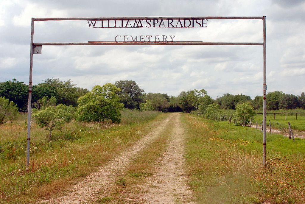
| Description | : | Chartie Williams Community Cemetery Origin of name: after Chartie Williams, who donated the land Source of name: Commissioners Court Minutes Alternate name: Williams Paradise Cemetery Origin of alternate name: unknown Source of alternate name: death certificates Location: about one-tenth of a mile west of Highway 71, between 3.5 and 4 miles south of its intersection with Highway 90A, or about one mile north of its intersection with Duncan Lane (County Road 111) Map: 2996-422, Altair Quadrangle (not marked) Earliest known year of death: 1936 Earliest known year of birth: 1865 Most recent known burial: 2000 Racial mix: all black Comments: 1. On August 23, 1954, Chartie M. Williams petitioned the Colorado County... Read More |
frequently asked questions (FAQ):
-
Where is Williams Paradise Cemetery?
Williams Paradise Cemetery is located at County Road 130 Nada, Colorado County ,Texas , 77442USA.
-
Williams Paradise Cemetery cemetery's updated grave count on graveviews.com?
0 memorials
-
Where are the coordinates of the Williams Paradise Cemetery?
Latitude: 29.5220270
Longitude: -96.4399500
Nearby Cemetories:
1. Vox Populi Cemetery
Garwood, Colorado County, USA
Coordinate: 29.5103170, -96.4180010
2. Alexander Cemetery
Garwood, Colorado County, USA
Coordinate: 29.5102030, -96.4180070
3. Brown Family Cemetery
Altair, Colorado County, USA
Coordinate: 29.5562520, -96.4581570
4. Lehrer Memorial Cemetery
Garwood, Colorado County, USA
Coordinate: 29.4874500, -96.4164800
5. Abell Cemetery
Garwood, Colorado County, USA
Coordinate: 29.4841570, -96.3919240
6. Reels Bend Cemetery
Colorado County, USA
Coordinate: 29.6013270, -96.4267730
7. Garwood Cemetery
Colorado County, USA
Coordinate: 29.4403000, -96.4364014
8. Tait Cemetery
Columbus, Colorado County, USA
Coordinate: 29.6095280, -96.4657500
9. Montgomery-Thatcher Cemetery
Matthews, Colorado County, USA
Coordinate: 29.5046630, -96.3333840
10. Wright Cemetery
Altair, Colorado County, USA
Coordinate: 29.6190950, -96.4423230
11. Boykin Cemetery
Colorado County, USA
Coordinate: 29.5263996, -96.3249969
12. Union Hill Cemetery
Colorado County, USA
Coordinate: 29.4964008, -96.3261032
13. Rising Star Cemetery
Colorado County, USA
Coordinate: 29.5953460, -96.3560730
14. Nativity Cemetery
Eagle Lake, Colorado County, USA
Coordinate: 29.5882140, -96.3470880
15. Lakeside Cemetery
Eagle Lake, Colorado County, USA
Coordinate: 29.5746994, -96.3339005
16. Myrtle Cemetery
Rock Island, Colorado County, USA
Coordinate: 29.5105991, -96.5682983
17. Eagle Lake Masonic Cemetery
Eagle Lake, Colorado County, USA
Coordinate: 29.5941300, -96.3321000
18. Adams Cemetery
Colorado County, USA
Coordinate: 29.6392002, -96.4116974
19. Eagle Lake Community Cemetery North
Eagle Lake, Colorado County, USA
Coordinate: 29.5951100, -96.3306400
20. Eagle Lake Community Cemetery East
Eagle Lake, Colorado County, USA
Coordinate: 29.5819500, -96.3197600
21. Saint Marys Cemetery
Nada, Colorado County, USA
Coordinate: 29.4075160, -96.3800870
22. Hurr Family Cemetery
Rock Island, Colorado County, USA
Coordinate: 29.4612810, -96.5666820
23. Nada Cemetery
Colorado County, USA
Coordinate: 29.3913994, -96.4178009
24. Samuel Wright Cemetery
Columbus, Colorado County, USA
Coordinate: 29.6503000, -96.4875260