
| Memorials | : | 0 |
| Location | : | McCaulley, Fisher County, USA |
| Coordinate | : | 32.8075000, -100.4319440 |
| Description | : | 10 miles east of Roby on US 180, at intersection with FM 1812. Historical marker is at the corner of HWY 180 and FM1812. To drive to cemetery you go south from historical marker on FM1812, then turn right on CR 156. Next right is into dirt road to cemetery about 1 mile. |
frequently asked questions (FAQ):
-
Where is Woods Chapel Cemetery?
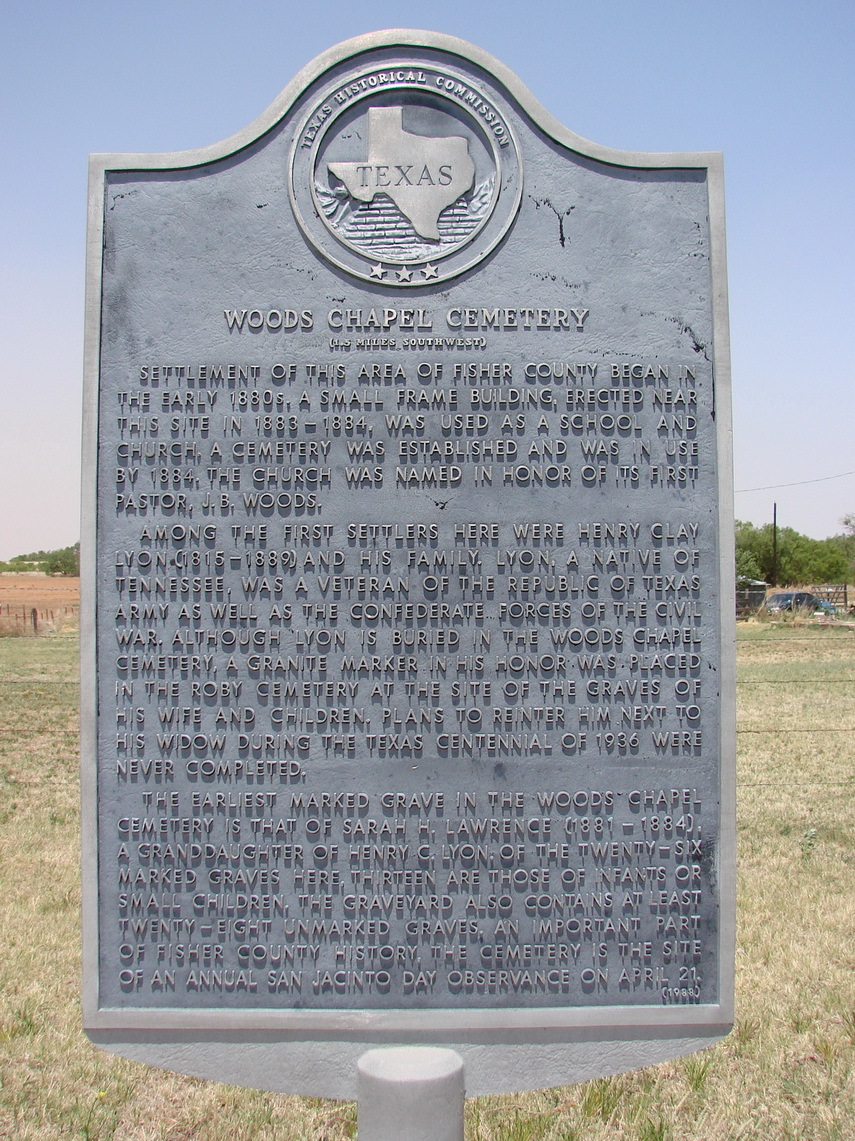
Woods Chapel Cemetery is located at McCaulley, Fisher County ,Texas ,USA.
-
Woods Chapel Cemetery cemetery's updated grave count on graveviews.com?
0 memorials
-
Where are the coordinates of the Woods Chapel Cemetery?
Latitude: 32.8075000
Longitude: -100.4319440
Nearby Cemetories:
1. Fisher Cemetery
Fisher, Fisher County, USA
Coordinate: 32.8056400, -100.3806600
2. Belvieu Cemetery
Rotan, Fisher County, USA
Coordinate: 32.8591995, -100.4408035
3. Roby Cemetery
Roby, Fisher County, USA
Coordinate: 32.7619019, -100.3732986
4. Sardis Cemetery
Sardis, Fisher County, USA
Coordinate: 32.7572220, -100.4961110
5. Dowell Cemetery
Rotan, Fisher County, USA
Coordinate: 32.9039001, -100.4289017
6. Hobbs Cemetery
Hobbs, Fisher County, USA
Coordinate: 32.7633018, -100.5856018
7. Mount Zion Cemetery
Fisher County, USA
Coordinate: 32.8955994, -100.2900009
8. Yopp Ranch Cemetery
Hamlin, Fisher County, USA
Coordinate: 32.8779000, -100.2733000
9. El Ranchito Cemetery
Rotan, Fisher County, USA
Coordinate: 32.8805960, -100.2646210
10. Grady Cemetery
Fisher County, USA
Coordinate: 32.8619003, -100.6157990
11. Longworth Cemetery
Longworth, Fisher County, USA
Coordinate: 32.6523030, -100.3547110
12. Swedonia Cemetery
Fisher County, USA
Coordinate: 32.8361830, -100.2277990
13. Sylvester Cemetery
Sylvester, Fisher County, USA
Coordinate: 32.7010994, -100.2680969
14. Afton Cemetery
Hamlin, Fisher County, USA
Coordinate: 32.8941994, -100.2294006
15. McCaulley Cemetery
McCaulley, Fisher County, USA
Coordinate: 32.7685900, -100.2008700
16. Claytonville Cemetery
Claytonville, Fisher County, USA
Coordinate: 32.6460640, -100.5699160
17. Aiken Ranch Cemetery
Fisher County, USA
Coordinate: 32.6127140, -100.5410520
18. Palava Cemetery
Palava, Fisher County, USA
Coordinate: 32.5776000, -100.3388000
19. Newman Cemetery
Sylvester, Fisher County, USA
Coordinate: 32.6165540, -100.2140960
20. Bernecker Cemetery
Fisher County, USA
Coordinate: 32.5487270, -100.5645140
21. York Cemetery
Borden County, USA
Coordinate: 32.7719002, -101.2138977
22. Steele Hill Cemetery
Spur, Dickens County, USA
Coordinate: 33.4211390, -100.7882370
23. Justiceburg Cemetery
Garza County, USA
Coordinate: 33.0453260, -101.1963540
24. Durham Cemetery
Borden County, USA
Coordinate: 32.7108002, -101.2692032