

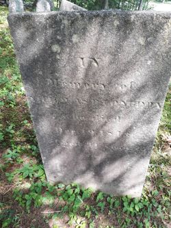
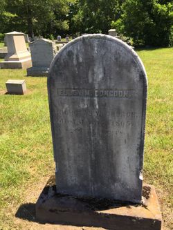
Abby Lamb Congdon Smith
| Birth | : | 1835 Connecticut, USA |
| Death | : | 3 Nov 1898 Montville, New London County, Connecticut, USA |
| Burial | : | Bonshaw Burial Ground, Cranbrook Shire, Australia |
| Coordinate | : | -34.1871390, 117.3203610 |
| Description | : | She was born February 22, 1834. Married 1) John Fowler; 2) John Smith Mother of Frank Fowler, born December 21, 1856. |
frequently asked questions (FAQ):
-
Where is Abby Lamb Congdon Smith's memorial?
Abby Lamb Congdon Smith's memorial is located at: Bonshaw Burial Ground, Cranbrook Shire, Australia.
-
When did Abby Lamb Congdon Smith death?
Abby Lamb Congdon Smith death on 3 Nov 1898 in Montville, New London County, Connecticut, USA
-
Where are the coordinates of the Abby Lamb Congdon Smith's memorial?
Latitude: -34.1871390
Longitude: 117.3203610
Family Members:
Parent
Spouse
Siblings
Flowers:


Nearby Cemetories:
1. Bonshaw Burial Ground
Cranbrook Shire, Australia
Coordinate: -34.1871390, 117.3203610
2. Pindellup St. Peters Church of England
Tambellup, Broomehill-Tambellup Shire, Australia
Coordinate: -33.9755683, 117.4940883
3. Tenterden War Memorial
Tenterden, Cranbrook Shire, Australia
Coordinate: -34.3652200, 117.5584600
4. Tenterden General Cemetery
Tenterden, Cranbrook Shire, Australia
Coordinate: -34.3652251, 117.5709322
5. Wansbrough Burial
Wansbrough, Broomehill-Tambellup Shire, Australia
Coordinate: -34.1425430, 117.6733960
6. Tambellup Cemetery
Tambellup, Broomehill-Tambellup Shire, Australia
Coordinate: -34.0353790, 117.6330330
7. Kojonup Cemetery
Kojonup, Kojonup Shire, Australia
Coordinate: -33.8248400, 117.1526770
8. Eticup Cemetery
Broomehill, Broomehill-Tambellup Shire, Australia
Coordinate: -33.8328280, 117.5639560
9. Broomehill Cemetery
Broomehill, Broomehill-Tambellup Shire, Australia
Coordinate: -33.8477960, 117.6227830
10. Muradup Cemetery
Muradup, Kojonup Shire, Australia
Coordinate: -33.8454740, 116.9805800
11. Chowerup Cemetery
Chowerup, Boyup Brook Shire, Australia
Coordinate: -34.0858380, 116.7028610
12. Mount Barker Cemetery West
Mount Barker, Plantagenet Shire, Australia
Coordinate: -34.6437679, 117.6692459
13. Mount Barker Cemetery East
Mount Barker, Plantagenet Shire, Australia
Coordinate: -34.6437373, 117.6709039
14. St. Werburgh's Chapel & Cemetery
Mount Barker, Plantagenet Shire, Australia
Coordinate: -34.6853069, 117.5996387
15. Katanning Cemetery
Katanning, Katanning Shire, Australia
Coordinate: -33.6682290, 117.5462430
16. Boscabel Cemetery
Boscabel, Kojonup Shire, Australia
Coordinate: -33.6658750, 117.0671800
17. Gnowangerup Cemetery
Gnowangerup, Gnowangerup Shire, Australia
Coordinate: -33.9461540, 118.0135490
18. Dinninup Cemetery
Boyup Brook Shire, Australia
Coordinate: -33.7845110, 116.5315440
19. Denmark Public Cemetery
Denmark, Denmark Shire, Australia
Coordinate: -34.9542900, 117.3764500
20. Borden Cemetery
Borden, Gnowangerup Shire, Australia
Coordinate: -34.0727430, 118.2646100
21. Boyup Brook Public Cemetery
Boyup Brook, Boyup Brook Shire, Australia
Coordinate: -33.8193550, 116.3932030
22. Balbarrup Pioneer Cemetery
Manjimup, Manjimup Shire, Australia
Coordinate: -34.2170700, 116.2078400
23. Walpole Cemetery
Walpole, Manjimup Shire, Australia
Coordinate: -34.9787030, 116.7456710
24. Balbarrup Cemetery
Balbarrup, Manjimup Shire, Australia
Coordinate: -34.2177720, 116.1984000