
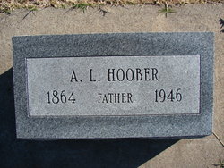
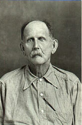
Abraham L. “Lewis” Hoober
| Birth | : | 7 Jun 1866 |
| Death | : | 6 Dec 1946 El Dorado, Butler County, Kansas, USA |
| Burial | : | Brown Cemetery, Donegal Township, Westmoreland County, USA |
| Coordinate | : | 40.1016998, -79.4064026 |
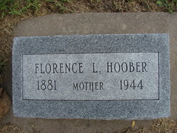
| Description | : | Lewis was married at least three times. Known wives were Katherine Stella Stark, married 28 May 1897 Branson, Taney, Missouri; Rosa "Esther" Rogers, married 22 Aug 1904 Waynesville, Pulaski, Missouri; and Florence L. Walters, 3 Sep 1910 Harper, Harper, Kansas. ____ El Dorado Times El Dorado, KS Dec. 6, 1946 Abraham L. Hoober dies this morning Abraham Louis Hoober, aged 83 years, a resident of El Dorado for some time, died this morning. He resided at 206 North Gordy street. Mr. Hoober was born in Indiana. He was married to Florence Lavina Walters... Read More |
frequently asked questions (FAQ):
-
Where is Abraham L. “Lewis” Hoober's memorial?
Abraham L. “Lewis” Hoober's memorial is located at: Brown Cemetery, Donegal Township, Westmoreland County, USA.
-
When did Abraham L. “Lewis” Hoober death?
Abraham L. “Lewis” Hoober death on 6 Dec 1946 in El Dorado, Butler County, Kansas, USA
-
Where are the coordinates of the Abraham L. “Lewis” Hoober's memorial?
Latitude: 40.1016998
Longitude: -79.4064026
Family Members:
Parent

Spouse
Siblings
Children
Flowers:


Nearby Cemetories:
1. Brown Cemetery
Donegal Township, Westmoreland County, USA
Coordinate: 40.1016998, -79.4064026
2. Keslar Cemetery
Fayette County, USA
Coordinate: 40.0995100, -79.4145100
3. Donegal Cemetery
Donegal, Westmoreland County, USA
Coordinate: 40.1112000, -79.3785000
4. Hays Cemetery
Mount Pleasant, Westmoreland County, USA
Coordinate: 40.1259000, -79.4021000
5. Walnut Hill Cemetery
Donegal, Westmoreland County, USA
Coordinate: 40.1040000, -79.3659000
6. Eutsey Cemetery Old
Fayette County, USA
Coordinate: 40.0781400, -79.4427900
7. Porch Cemetery
Donegal, Westmoreland County, USA
Coordinate: 40.1306000, -79.3711014
8. Byerly Freeman Cemetery
Mount Pleasant, Westmoreland County, USA
Coordinate: 40.1432500, -79.4100900
9. Eutsey Cemetery
Fayette County, USA
Coordinate: 40.0742400, -79.4474900
10. Melcroft Cemetery
Fayette County, USA
Coordinate: 40.0561000, -79.3829000
11. Knopsnider Cemetery New
Bullskin Township, Fayette County, USA
Coordinate: 40.0685400, -79.4686800
12. Knopsnider Cemetery (Old)
Bullskin Township, Fayette County, USA
Coordinate: 40.0691400, -79.4704800
13. Stouffer Cemetery
Bullskin Township, Fayette County, USA
Coordinate: 40.0848990, -79.4816900
14. Saint Raymonds Cemetery
Melcroft, Fayette County, USA
Coordinate: 40.0572014, -79.3531036
15. Mount Nebo Cemetery
Indian Head, Fayette County, USA
Coordinate: 40.0531000, -79.3556000
16. Dan Snyder Cemetery
Fayette County, USA
Coordinate: 40.0408000, -79.4317000
17. Mellinger Cemetery
Mellingertown, Westmoreland County, USA
Coordinate: 40.1432050, -79.4784730
18. Nicholson Cemetery
Clinton, Fayette County, USA
Coordinate: 40.0506100, -79.4745600
19. Good Hope Lutheran Cemetery
Fayette County, USA
Coordinate: 40.0282000, -79.3893900
20. Lobingier Cemetery
Mount Pleasant Township, Westmoreland County, USA
Coordinate: 40.1439030, -79.4887870
21. Franklin Lutheran Cemetery
Kregar, Westmoreland County, USA
Coordinate: 40.1215000, -79.3085000
22. Sparks Cemetery
Indian Head, Fayette County, USA
Coordinate: 40.0239200, -79.3892500
23. Brothers Cemetery
Fayette County, USA
Coordinate: 40.1360700, -79.5004300
24. Fairview Cemetery
Kecksburg, Westmoreland County, USA
Coordinate: 40.1696000, -79.4634000