
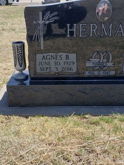
Agnes “Aggie” Pfannenstiel Herman
| Birth | : | 30 Jun 1929 Trego County, Kansas, USA |
| Death | : | 3 Sep 2016 Dighton, Lane County, Kansas, USA |
| Burial | : | Dighton Cemetery, Dighton, Lane County, USA |
| Coordinate | : | 38.4832993, -100.4297028 |
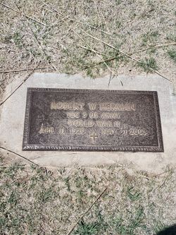
| Description | : | Dateline: Dighton Name: Agnes “Aggie” Herman Age: 87 Died: Saturday, September 3, 2016 at her home in Dighton Born: June 30, 1929 in Trego County Parents: Fidelis J. & Margaret (Leiker) Pfannenstiel Marriage: to Robert W. Herman on August 12, 1947 at Collyer He died on May 31, 2003 Memberships: St Theresa Catholic Church of Dighton Altar Society Red Hat Society Aggie on born on a farm and her family moved to Gove County where she attended Country Schools. During World War II her brothers were in the service so she worked on the farm and restaurants to help support the family. She lived in Shields for many years and... Read More |
frequently asked questions (FAQ):
-
Where is Agnes “Aggie” Pfannenstiel Herman's memorial?
Agnes “Aggie” Pfannenstiel Herman's memorial is located at: Dighton Cemetery, Dighton, Lane County, USA.
-
When did Agnes “Aggie” Pfannenstiel Herman death?
Agnes “Aggie” Pfannenstiel Herman death on 3 Sep 2016 in Dighton, Lane County, Kansas, USA
-
Where are the coordinates of the Agnes “Aggie” Pfannenstiel Herman's memorial?
Latitude: 38.4832993
Longitude: -100.4297028
Family Members:
Flowers:


Nearby Cemetories:
1. Dighton Cemetery
Dighton, Lane County, USA
Coordinate: 38.4832993, -100.4297028
2. Shields Cemetery
Shields, Lane County, USA
Coordinate: 38.6267014, -100.4424973
3. Ward Cemetery
Shields, Lane County, USA
Coordinate: 38.3967800, -100.2826400
4. White Rock Cemetery
Lane County, USA
Coordinate: 38.6258011, -100.3311005
5. Sutton Cemetery
Lane County, USA
Coordinate: 38.3711014, -100.6113968
6. Beeler Cemetery
Ness County, USA
Coordinate: 38.4502983, -100.1967010
7. Thomas Cemetery
Lane County, USA
Coordinate: 38.3325005, -100.2718964
8. Healy Cemetery
Healy, Lane County, USA
Coordinate: 38.6131600, -100.6230900
9. Grigston Cemetery
Grigston, Scott County, USA
Coordinate: 38.4603400, -100.6996500
10. Utica Cemetery
Utica, Ness County, USA
Coordinate: 38.6464005, -100.1580963
11. Buda Cemetery
Beeler, Ness County, USA
Coordinate: 38.2900009, -100.1755981
12. Prairie Chapel Cemetery
Ness County, USA
Coordinate: 38.5946999, -100.0730972
13. Ravanna Cemetery
Ravanna, Finney County, USA
Coordinate: 38.1747970, -100.3824370
14. Alanthus Cemetery
Gove County, USA
Coordinate: 38.7731018, -100.2822037
15. Swedish Lutheran Cemetery
Gove, Gove County, USA
Coordinate: 38.7655983, -100.6089020
16. Arnold Cemetery
Arnold, Ness County, USA
Coordinate: 38.6474991, -100.0468979
17. Eminence Cemetery
Finney County, USA
Coordinate: 38.1464005, -100.5175018
18. North Star Cemetery
Ness County, USA
Coordinate: 38.5219500, -99.9916800
19. Saint Ignatius Cemetery
Laird, Ness County, USA
Coordinate: 38.2956900, -100.0587500
20. Amish Cemetery
Arnold, Ness County, USA
Coordinate: 38.6814003, -100.0556030
21. Rauch Family Cemetery
Trego County, USA
Coordinate: 38.7086090, -100.0799100
22. Mishler Cemetery
Ness County, USA
Coordinate: 38.3921300, -99.9910300
23. Kidderville Cemetery
Hodgeman County, USA
Coordinate: 38.1903000, -100.1541977
24. Morning Star Cemetery
Gove County, USA
Coordinate: 38.8431015, -100.3349991