

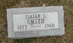
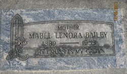
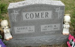
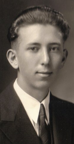
Agnes Mary Smith Comer Guthrie
| Birth | : | 1 Jun 1918 Lethbridge, Lethbridge Census Division, Alberta, Canada |
| Death | : | 16 Aug 1993 Des Moines, Polk County, Iowa, USA |
| Burial | : | Mayflower Hill Cemetery, Taunton, Bristol County, USA |
| Coordinate | : | 41.9199982, -71.0875015 |
| Description | : | Agnes Comer Guthrie, 75, of Granger died of complications of diabetes on August 16, 1993 at Mercy Hospital Medical Center at Des Moines. She was born at Lethbridge, Alberta, Canada and had lived at Granger since 1942. Survivors include her husband, Richard of Granger; seven daughters, Gertrude Schultze of Dallas Center, Kathleen Soltis of Waukesha, Wisconsin, Marguerite Jones of Madrid, Rose Fisher of Des Moines, Maureen Wolfe of Norfolk, Mass., Barbara Gonseth of Granger and Virginia Wren of Johnston; a son, George Comer Jr. of Durant; 19 grandchildren; and nine great-grandchildren. |
frequently asked questions (FAQ):
-
Where is Agnes Mary Smith Comer Guthrie's memorial?
Agnes Mary Smith Comer Guthrie's memorial is located at: Mayflower Hill Cemetery, Taunton, Bristol County, USA.
-
When did Agnes Mary Smith Comer Guthrie death?
Agnes Mary Smith Comer Guthrie death on 16 Aug 1993 in Des Moines, Polk County, Iowa, USA
-
Where are the coordinates of the Agnes Mary Smith Comer Guthrie's memorial?
Latitude: 41.9199982
Longitude: -71.0875015
Family Members:
Parent
Spouse
Children

Flowers:


Nearby Cemetories:
1. Mayflower Hill Cemetery
Taunton, Bristol County, USA
Coordinate: 41.9199982, -71.0875015
2. Saint Mary Cemetery
Taunton, Bristol County, USA
Coordinate: 41.9219900, -71.0878900
3. Saint Joseph Cemetery
Taunton, Bristol County, USA
Coordinate: 41.9199982, -71.0792007
4. Plain Cemetery
Taunton, Bristol County, USA
Coordinate: 41.9124985, -71.0916977
5. Father Wilson Cemetery
Taunton, Bristol County, USA
Coordinate: 41.9087600, -71.0921900
6. Ox Bow Farm Cemetery
Taunton, Bristol County, USA
Coordinate: 41.9027020, -71.0714260
7. Neck O Land Cemetery
Taunton, Bristol County, USA
Coordinate: 41.8978500, -71.0850000
8. Dean Cemetery
Raynham, Bristol County, USA
Coordinate: 41.9053970, -71.0616490
9. Wetherell Cemetery
Taunton, Bristol County, USA
Coordinate: 41.9449200, -71.0886700
10. Seth Staples Gravesite
Taunton, Bristol County, USA
Coordinate: 41.8954700, -71.0730000
11. Shaw Cemetery
Raynham, Bristol County, USA
Coordinate: 41.9081400, -71.0550000
12. Mount Pleasant Cemetery
Taunton, Bristol County, USA
Coordinate: 41.8941500, -71.1009100
13. Brittun Cemetery
Raynham, Bristol County, USA
Coordinate: 41.9446800, -71.0698100
14. Bassett Street Cemetery
Taunton, Bristol County, USA
Coordinate: 41.9395100, -71.1156200
15. Pleasant Street Cemetery
Raynham, Bristol County, USA
Coordinate: 41.9277992, -71.0477982
16. Saint Thomas Episcopal Burying Ground
Taunton, Bristol County, USA
Coordinate: 41.9105900, -71.1270100
17. Bezer Lincoln Cemetery
Taunton, Bristol County, USA
Coordinate: 41.9429800, -71.1153300
18. Asa Lincoln Family Gravesite
Taunton, Bristol County, USA
Coordinate: 41.9043950, -71.1240160
19. Britton Cemetery
Raynham, Bristol County, USA
Coordinate: 41.9440800, -71.0579800
20. Harvey Family Burying Ground
Taunton, Bristol County, USA
Coordinate: 41.9408500, -71.1231300
21. Crane Avenue South Thayer Family Burial Ground
Taunton, Bristol County, USA
Coordinate: 41.9288300, -71.1336900
22. Mount Nebo Cemetery
Taunton, Bristol County, USA
Coordinate: 41.9091988, -71.1339035
23. Oakland Cemetery
Taunton, Bristol County, USA
Coordinate: 41.9078700, -71.1337600
24. King Cemetery
Raynham, Bristol County, USA
Coordinate: 41.9019020, -71.0439020