
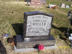
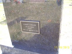
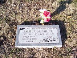
Albert L. Miller
| Birth | : | 5 Sep 1933 Circleville, Jackson County, Kansas, USA |
| Death | : | 17 May 2004 Topeka, Shawnee County, Kansas, USA |
| Burial | : | Moquino Cemetery, Moquino, Cibola County, USA |
| Coordinate | : | 35.1706620, -107.3647840 |
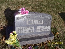
| Description | : | Albert L. Miller, 70, Topeka, formerly of Circleville, died Monday, May 17, 2004, at a Topeka hospital. He was born Sept. 5, 1933, in Circleville, the son of Albert W. and Susie E. Matlock Miller. He was a self-employed carpenter for many years and also was a farmer. He moved to Topeka from Circleville 25 years ago. He was a member of VFW Post No. 1650, Moose Lodge No. 555 and Shawnee Swingers Square Dance club, all in Topeka. He married Bula L. Brocklesby. They were later divorced. Survivors include a son, Bill Miller, Circleville; two daughters, Cynthia Scott, Topeka, and Tamara McDaniel, Mayetta; four... Read More |
frequently asked questions (FAQ):
-
Where is Albert L. Miller's memorial?
Albert L. Miller's memorial is located at: Moquino Cemetery, Moquino, Cibola County, USA.
-
When did Albert L. Miller death?
Albert L. Miller death on 17 May 2004 in Topeka, Shawnee County, Kansas, USA
-
Where are the coordinates of the Albert L. Miller's memorial?
Latitude: 35.1706620
Longitude: -107.3647840
Family Members:
Parent

Siblings
Children
Flowers:


Nearby Cemetories:
1. Moquino Cemetery
Moquino, Cibola County, USA
Coordinate: 35.1706620, -107.3647840
2. Bibo Cemetery
Cibola County, USA
Coordinate: 35.1772040, -107.3968120
3. Paguate Cemetery
Paguate, Cibola County, USA
Coordinate: 35.1385994, -107.3783035
4. Seboyeta Cemetery
Seboyeta, Cibola County, USA
Coordinate: 35.2029080, -107.3823520
5. Eckerman Cemetery
Cibola County, USA
Coordinate: 35.0491982, -107.4278030
6. San Jose Cemetery
Laguna, Cibola County, USA
Coordinate: 35.0367260, -107.3921570
7. Cubero Cemetery
Cubero, Cibola County, USA
Coordinate: 35.0786000, -107.5093000
8. Casa Blanca Cemetery
Casa Blanca, Cibola County, USA
Coordinate: 35.0416000, -107.4616000
9. Paraje Cemetery
Paraje, Cibola County, USA
Coordinate: 35.0456009, -107.4708023
10. Marquez Cemetery
Marquez, Sandoval County, USA
Coordinate: 35.3162510, -107.3064060
11. Mesita Cemetery
Mesita, Cibola County, USA
Coordinate: 35.0186500, -107.3133200
12. Mission San Jose de Laguna Churchyard
Laguna, Cibola County, USA
Coordinate: 35.0391050, -107.2543070
13. Budville Cemetery
Cibola County, USA
Coordinate: 35.0785000, -107.5242000
14. Laguna-Acoma Baptist Indian Mission Cemetery
Cubero, Cibola County, USA
Coordinate: 35.0670731, -107.5255031
15. New York Cemetery
New York, Cibola County, USA
Coordinate: 35.0575000, -107.5333000
16. Seama Village Cemetery
Seama, Cibola County, USA
Coordinate: 35.0367630, -107.5255470
17. Herrera Cemetery Upper
Herrera, Bernalillo County, USA
Coordinate: 35.1922670, -107.1147000
18. Ethridge Family Cemetery
San Fidel, Cibola County, USA
Coordinate: 35.0827655, -107.5982033
19. San Fidel Cemetery
San Fidel, Cibola County, USA
Coordinate: 35.0821991, -107.5986023
20. Acomita Cemetery
Acomita, Cibola County, USA
Coordinate: 35.0507590, -107.5950070
21. Tohajiilee Cemetery
McKinley County, USA
Coordinate: 35.1453000, -107.0860000
22. McCartys Cemetery
McCartys, Cibola County, USA
Coordinate: 35.0611430, -107.6716590
23. San Mateo Cemetery
San Mateo, Cibola County, USA
Coordinate: 35.3310570, -107.6425840
24. San Esteban Del Rey Mission Cemetery
Acoma Pueblo, Cibola County, USA
Coordinate: 34.8952640, -107.5820690