
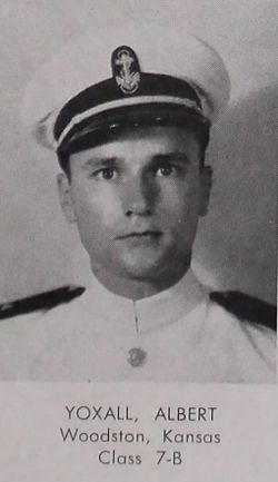


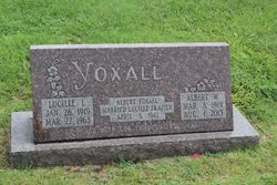
Albert Warren Yoxall
| Birth | : | 8 Mar 1919 Woodston, Rooks County, Kansas, USA |
| Death | : | 1 Aug 2015 Fort Collins, Larimer County, Colorado, USA |
| Burial | : | Woodston Cemetery, Woodston, Rooks County, USA |
| Coordinate | : | 39.4375000, -99.1268997 |
| Inscription | : | Married Apr. 5, 1942 |
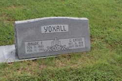
| Description | : | Albert Warren Yoxall, 96, of Fort Collins passed away August 1, 2015, surrounded by his family. Albert Yoxall was born on the Yoxall farm near Woodston, Kansas on March 8, 1919 to George Eaton Yoxall and Maude Fairbanks Yoxall. He grew up on the farm and graduated from Woodston High School in 1937. After graduating from Kansas State University, Albert joined the Navy. Upon graduating from flight training, he married Lucille Frazier(his high school sweetheart). During WWII, Albert was assigned to a squadron of airplanes attached to the air craft carrier Chenango. He flew Grumman TBF (Avenger) airplanes... Read More |
frequently asked questions (FAQ):
-
Where is Albert Warren Yoxall's memorial?
Albert Warren Yoxall's memorial is located at: Woodston Cemetery, Woodston, Rooks County, USA.
-
When did Albert Warren Yoxall death?
Albert Warren Yoxall death on 1 Aug 2015 in Fort Collins, Larimer County, Colorado, USA
-
Where are the coordinates of the Albert Warren Yoxall's memorial?
Latitude: 39.4375000
Longitude: -99.1268997
Family Members:
Parent

Spouse

Siblings
Flowers:


Nearby Cemetories:
1. Woodston Cemetery
Woodston, Rooks County, USA
Coordinate: 39.4375000, -99.1268997
2. Survey Cemetery
Woodston, Rooks County, USA
Coordinate: 39.3722000, -99.1333008
3. Spring Branch Cemetery
Woodston, Rooks County, USA
Coordinate: 39.5099983, -99.0580978
4. West Hope Cemetery
Rooks County, USA
Coordinate: 39.5024986, -99.2110977
5. Ash Rock Cemetery
Woodston, Rooks County, USA
Coordinate: 39.5248909, -99.0817719
6. Pleasant Valley Cemetery
Osborne County, USA
Coordinate: 39.4583015, -99.0077972
7. Johnson Cemetery
Stockton, Rooks County, USA
Coordinate: 39.3493996, -99.1941986
8. Stockton Cemetery
Stockton, Rooks County, USA
Coordinate: 39.4406700, -99.2647400
9. Saint Thomas Cemetery
Stockton, Rooks County, USA
Coordinate: 39.4449997, -99.2771988
10. Chalk Mound Cemetery
Laton, Rooks County, USA
Coordinate: 39.3208008, -99.0852966
11. Pleasant Plain Cemetery
Osborne County, USA
Coordinate: 39.3367004, -99.0372009
12. Pioneer Cemetery
Alton, Osborne County, USA
Coordinate: 39.4742012, -98.9749985
13. Mount Ayr Cemetery
Alton, Osborne County, USA
Coordinate: 39.3764000, -98.9717026
14. Old Stockton Cemetery
Stockton, Rooks County, USA
Coordinate: 39.4597015, -99.3050003
15. Bigge Family Cemetery
Stockton, Rooks County, USA
Coordinate: 39.4584700, -99.3053200
16. Grant Center Cemetery
Alton, Osborne County, USA
Coordinate: 39.5242004, -98.9708023
17. Sumner Cemetery
Alton, Osborne County, USA
Coordinate: 39.4799995, -98.9338913
18. Pleasant Ridge Cemetery
Kirwin, Phillips County, USA
Coordinate: 39.5963000, -99.1234000
19. Aurora Cemetery
Laton, Rooks County, USA
Coordinate: 39.2778015, -99.0847015
20. Greenwood Cemetery
Kirwin, Phillips County, USA
Coordinate: 39.5931900, -99.2064600
21. Bow Creek Cemetery
Glade, Phillips County, USA
Coordinate: 39.5681000, -99.2696991
22. Twin Mound Cemetery
Rooks County, USA
Coordinate: 39.2855988, -99.2319031
23. Kill Creek Cemetery
Alton, Osborne County, USA
Coordinate: 39.3805528, -98.8967658
24. Leasburg Cemetery
Cedar, Smith County, USA
Coordinate: 39.5819016, -98.9728012