
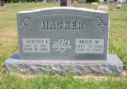
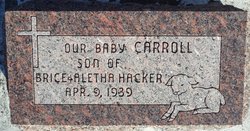
Aletha Lavena Allen Hacker
| Birth | : | 16 Jan 1913 Welch, Craig County, Oklahoma, USA |
| Death | : | 16 Jun 2011 Wichita, Sedgwick County, Kansas, USA |
| Burial | : | Brown Cemetery, Donegal Township, Westmoreland County, USA |
| Coordinate | : | 40.1016998, -79.4064026 |
| Plot | : | Section: SS Lot: 752 Space: 2 |
| Description | : | El Dorado, Kan. — Aletha L. Hacker, 98, a former El Dorado resident, died Thursday, June 16, 2011 at College Hill Nursing and Rehabilitation in Wichita. Services will be at 2 p.m. Monday at Carlson Funeral Home, El Dorado. Interment will follow in Sunset Lawns Cemetery. Friends may call at the Funeral Home from noont o 8 p.m. Saturday, with the family present from 2 to 6. Friends may also call on Sunday from noon to 8 p.m. at the Funeral Home. She was born on Jan. 16, 1913 in Welch, Okla., the daughter of Isaac... Read More |
frequently asked questions (FAQ):
-
Where is Aletha Lavena Allen Hacker's memorial?
Aletha Lavena Allen Hacker's memorial is located at: Brown Cemetery, Donegal Township, Westmoreland County, USA.
-
When did Aletha Lavena Allen Hacker death?
Aletha Lavena Allen Hacker death on 16 Jun 2011 in Wichita, Sedgwick County, Kansas, USA
-
Where are the coordinates of the Aletha Lavena Allen Hacker's memorial?
Latitude: 40.1016998
Longitude: -79.4064026
Family Members:

Spouse

Children
Flowers:


Nearby Cemetories:
1. Brown Cemetery
Donegal Township, Westmoreland County, USA
Coordinate: 40.1016998, -79.4064026
2. Keslar Cemetery
Fayette County, USA
Coordinate: 40.0995100, -79.4145100
3. Donegal Cemetery
Donegal, Westmoreland County, USA
Coordinate: 40.1112000, -79.3785000
4. Hays Cemetery
Mount Pleasant, Westmoreland County, USA
Coordinate: 40.1259000, -79.4021000
5. Walnut Hill Cemetery
Donegal, Westmoreland County, USA
Coordinate: 40.1040000, -79.3659000
6. Eutsey Cemetery Old
Fayette County, USA
Coordinate: 40.0781400, -79.4427900
7. Porch Cemetery
Donegal, Westmoreland County, USA
Coordinate: 40.1306000, -79.3711014
8. Byerly Freeman Cemetery
Mount Pleasant, Westmoreland County, USA
Coordinate: 40.1432500, -79.4100900
9. Eutsey Cemetery
Fayette County, USA
Coordinate: 40.0742400, -79.4474900
10. Melcroft Cemetery
Fayette County, USA
Coordinate: 40.0561000, -79.3829000
11. Knopsnider Cemetery New
Bullskin Township, Fayette County, USA
Coordinate: 40.0685400, -79.4686800
12. Knopsnider Cemetery (Old)
Bullskin Township, Fayette County, USA
Coordinate: 40.0691400, -79.4704800
13. Stouffer Cemetery
Bullskin Township, Fayette County, USA
Coordinate: 40.0848990, -79.4816900
14. Saint Raymonds Cemetery
Melcroft, Fayette County, USA
Coordinate: 40.0572014, -79.3531036
15. Mount Nebo Cemetery
Indian Head, Fayette County, USA
Coordinate: 40.0531000, -79.3556000
16. Dan Snyder Cemetery
Fayette County, USA
Coordinate: 40.0408000, -79.4317000
17. Mellinger Cemetery
Mellingertown, Westmoreland County, USA
Coordinate: 40.1432050, -79.4784730
18. Nicholson Cemetery
Clinton, Fayette County, USA
Coordinate: 40.0506100, -79.4745600
19. Good Hope Lutheran Cemetery
Fayette County, USA
Coordinate: 40.0282000, -79.3893900
20. Lobingier Cemetery
Mount Pleasant Township, Westmoreland County, USA
Coordinate: 40.1439030, -79.4887870
21. Franklin Lutheran Cemetery
Kregar, Westmoreland County, USA
Coordinate: 40.1215000, -79.3085000
22. Sparks Cemetery
Indian Head, Fayette County, USA
Coordinate: 40.0239200, -79.3892500
23. Brothers Cemetery
Fayette County, USA
Coordinate: 40.1360700, -79.5004300
24. Fairview Cemetery
Kecksburg, Westmoreland County, USA
Coordinate: 40.1696000, -79.4634000