Alfred Ackermann Thomson
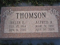
| Birth | : | 31 Mar 1910 Palmyra, Otoe County, Nebraska, USA |
| Death | : | 30 Jul 2008 Lincoln, Lancaster County, Nebraska, USA |
| Burial | : | Washington Grove Cemetery, Chana, Ogle County, USA |
| Coordinate | : | 41.9315262, -89.2565842 |
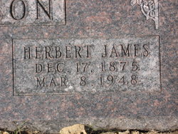
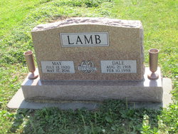
| Description | : | Alfred Ackermann Thomson, 98, Lincoln, died Wednesday, July 30, 2008. Born March 31, 1910, in rural Palmyra to Herbert James and Blanche Mabel (Klinefelter) Thomson. Retired farmer. Survived by: son, daughter-in-law, Dean A. and Elida Thomson, Lincoln; three grandchildren; five great-grandchildren; sisters, Alma Caddy and May Lamb. Preceded in death by: wife, Helen; son, Cloyd; parents; one sister; four brothers. Funeral services held Monday, August 4, at Lincoln Berean Church, 6400 South 70th. Pastor Doug Shada officiated. Burial in Rosewood Cemetery, Palmyra. Memorials to Back to the Bible or the church. http://incolor.inetnebr.com/voicenews/obits/2008%20Obits/ThomsonAlfred.htm |
frequently asked questions (FAQ):
-
Where is Alfred Ackermann Thomson's memorial?
Alfred Ackermann Thomson's memorial is located at: Washington Grove Cemetery, Chana, Ogle County, USA.
-
When did Alfred Ackermann Thomson death?
Alfred Ackermann Thomson death on 30 Jul 2008 in Lincoln, Lancaster County, Nebraska, USA
-
Where are the coordinates of the Alfred Ackermann Thomson's memorial?
Latitude: 41.9315262
Longitude: -89.2565842
Family Members:
Parent
Spouse
Siblings
Flowers:
Nearby Cemetories:
1. Washington Grove Cemetery
Chana, Ogle County, USA
Coordinate: 41.9315262, -89.2565842
2. Chapel Hill Cemetery
Chana, Ogle County, USA
Coordinate: 41.9310989, -89.2491989
3. Lighthouse Cemetery
Daysville, Ogle County, USA
Coordinate: 41.9466667, -89.3023300
4. Daysville Cemetery
Daysville, Ogle County, USA
Coordinate: 41.9742012, -89.3182983
5. Cooley Cemetery
Chana, Ogle County, USA
Coordinate: 41.9692001, -89.1746979
6. Ashton Cemetery
Ashton, Lee County, USA
Coordinate: 41.8600006, -89.2249985
7. County Farm Cemetery
Oregon, Ogle County, USA
Coordinate: 41.9919014, -89.3328018
8. Franklin Grove Cemetery
Franklin Grove, Lee County, USA
Coordinate: 41.8440018, -89.3059998
9. Flagg Center Cemetery
Flagg Center, Ogle County, USA
Coordinate: 41.9399986, -89.1294022
10. Stinsonian Cemetery
Paynes Point, Ogle County, USA
Coordinate: 42.0236015, -89.2174988
11. Mount Pleasant Cemetery
Paynes Point, Ogle County, USA
Coordinate: 42.0258713, -89.2063065
12. Emmanuel Lutheran Cemetery
Paynes Point, Ogle County, USA
Coordinate: 42.0264091, -89.2071533
13. Riverside Cemetery
Oregon, Ogle County, USA
Coordinate: 42.0177994, -89.3308029
14. Riverview Cemetery
Oregon, Ogle County, USA
Coordinate: 42.0275002, -89.3399963
15. Saint Mary's Cemetery
Oregon, Ogle County, USA
Coordinate: 42.0032997, -89.3767014
16. Girton Cemetery
Lee County, USA
Coordinate: 41.8670006, -89.3899994
17. Oak Ridge Cemetery
Grand Detour, Ogle County, USA
Coordinate: 41.9380989, -89.4160995
18. Grand Detour Cemetery
Grand Detour, Ogle County, USA
Coordinate: 41.9020500, -89.4117584
19. Saint Brides Episcopal Cemetery
Oregon, Ogle County, USA
Coordinate: 42.0270271, -89.3536911
20. Saint Peter's Episcopal Church Grounds
Grand Detour, Ogle County, USA
Coordinate: 41.8978300, -89.4147200
21. Better Place Forest
Ogle County, USA
Coordinate: 42.0411546, -89.3341425
22. Emmert Cemetery
Nachusa, Lee County, USA
Coordinate: 41.8381004, -89.3660965
23. Mount Zion Cemetery
Oregon, Ogle County, USA
Coordinate: 41.9930992, -89.4044037
24. Ebenezer Cemetery
Oregon, Ogle County, USA
Coordinate: 42.0572319, -89.2780380


