
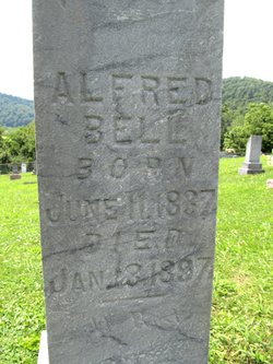
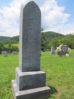
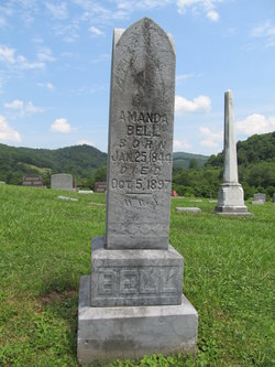
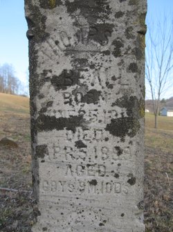
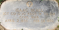
Alfred Beall
| Birth | : | 11 Jun 1837 West Virginia, USA |
| Death | : | 13 Jan 1897 De Kalb, Gilmer County, West Virginia, USA |
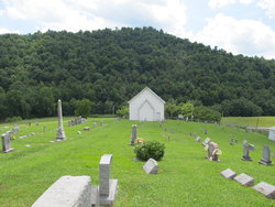
| Burial | : | Pisgah United Methodist Church Cemetery, De Kalb, Gilmer County, USA |
| Coordinate | : | 38.9425160, -80.9219560 |
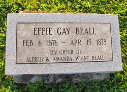
| Description | : | Alfred Beall was the son of Catherine Parsons and Townsend Beall. He served as Corporal in the 10th West Virginia Infantry (Union) during the Civil War. He was wounded at the Battle of Maryland Heights near Harper's Ferry and was present at Appomattox Court House, Virginia at the time of Lee's surrender. On November 17, 1867, he married Amanda Wiant, daughter of Margaret Lorena Lockard and Henry Wiant, in Gilmer County. The record of his death at age 59 describes his occupation as farmer. The Beall/Bell spellings were often used interchangeably. |
frequently asked questions (FAQ):
-
Where is Alfred Beall's memorial?
Alfred Beall's memorial is located at: Pisgah United Methodist Church Cemetery, De Kalb, Gilmer County, USA.
-
When did Alfred Beall death?
Alfred Beall death on 13 Jan 1897 in De Kalb, Gilmer County, West Virginia, USA
-
Where are the coordinates of the Alfred Beall's memorial?
Latitude: 38.9425160
Longitude: -80.9219560
Family Members:
Parent

Spouse
Siblings

Children
Flowers:


Nearby Cemetories:
1. Pisgah United Methodist Church Cemetery
De Kalb, Gilmer County, USA
Coordinate: 38.9425160, -80.9219560
2. Riddle Cemetery
Gilmer County, USA
Coordinate: 38.9547005, -80.9049988
3. Bell Cemetery
Gilmer County, USA
Coordinate: 38.9281006, -80.8933029
4. Three Poplar Cemetery
Glenville, Gilmer County, USA
Coordinate: 38.9628600, -80.9445500
5. Job's Temple Cemetery
Glenville, Gilmer County, USA
Coordinate: 38.9322220, -80.9618810
6. Holbert Cemetery
Gilmer County, USA
Coordinate: 38.9686012, -80.8944016
7. Woodford Cemetery
Gilmer County, USA
Coordinate: 38.9482994, -80.8778000
8. Meadow Lane Cemetery
Glenville, Gilmer County, USA
Coordinate: 38.9491997, -80.8775024
9. Barton Cemetery
Gilmer County, USA
Coordinate: 38.9449997, -80.8760986
10. Wilson Cemetery
Lucerne, Gilmer County, USA
Coordinate: 38.9744900, -80.9013700
11. Maxwell-Collins Cemetery
Hardman, Gilmer County, USA
Coordinate: 38.9043220, -80.9195185
12. Keister-Upper Beall Cemetery
Glenville, Gilmer County, USA
Coordinate: 38.9209800, -80.8788600
13. Good Shepherd Catholic Cemetery
Tanner, Gilmer County, USA
Coordinate: 38.9811830, -80.9447050
14. Tanner Baptist Church Cemetery
Gilmer County, USA
Coordinate: 38.9814310, -80.9480630
15. Cather Cemetery - Leading Creek
De Kalb, Gilmer County, USA
Coordinate: 38.9632780, -80.8707920
16. Riddle Cemetery
Hardman, Gilmer County, USA
Coordinate: 38.8961111, -80.9333333
17. Cox Cemetery
Normantown, Gilmer County, USA
Coordinate: 38.8953300, -80.9170500
18. Woodford Farm Cemetery
Lucerne, Gilmer County, USA
Coordinate: 38.9819600, -80.8880900
19. Shiloh Church Cemetery
Glenville, Gilmer County, USA
Coordinate: 38.9002200, -80.8920300
20. Tater Knob
Gilmer County, USA
Coordinate: 38.8988304, -80.8848038
21. Chestnut Grove Baptist Church Cemetery
Gilmer County, USA
Coordinate: 38.9340420, -80.9885860
22. Stalnaker Cemetery
Glenville, Gilmer County, USA
Coordinate: 38.9441986, -80.8514023
23. Brown Cemetery
Gilmer County, USA
Coordinate: 38.8869070, -80.9272360
24. Kelley Cemetery Crooked Run
Cedarville, Gilmer County, USA
Coordinate: 38.9042000, -80.8634200