
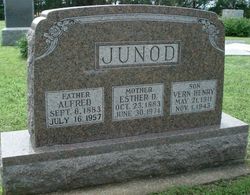
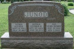
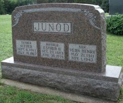
Alfred Paul “Toe” Junod
| Birth | : | 6 Sep 1883 Neuchatel Township, Nemaha County, Kansas, USA |
| Death | : | 16 Jul 1957 Neuchatel, Nemaha County, Kansas, USA |
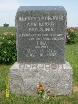
| Burial | : | Neuchatel Cemetery, Neuchatel, Nemaha County, USA |
| Coordinate | : | 39.5685196, -96.2015381 |
| Description | : | The Onaga Herald July 25, 1957 Alfred Junod was born on a farm near Onaga, September 6, 1883, the son of Mr. and Mrs. Alexander Junod, and died July 16, 1957 at the family farm in the Neuchatel community. He was united in marriage September 28, 1904 to Esther Allen. To this union were born a daughter who died in infancy and a son, Vern, who passed away in November 1943. They took their nephew, Wilbur Surdez, to rear when he was ten days old and bestowed upon him all the care of loving parents. Of... Read More |
frequently asked questions (FAQ):
-
Where is Alfred Paul “Toe” Junod's memorial?
Alfred Paul “Toe” Junod's memorial is located at: Neuchatel Cemetery, Neuchatel, Nemaha County, USA.
-
When did Alfred Paul “Toe” Junod death?
Alfred Paul “Toe” Junod death on 16 Jul 1957 in Neuchatel, Nemaha County, Kansas, USA
-
Where are the coordinates of the Alfred Paul “Toe” Junod's memorial?
Latitude: 39.5685196
Longitude: -96.2015381
Family Members:
Parent

Spouse
Siblings
Children
Flowers:


Nearby Cemetories:
1. Saint Pauls Lutheran Cemetery
Duluth, Pottawatomie County, USA
Coordinate: 39.5257988, -96.2311020
2. Saint Patricks Cemetery
Nemaha County, USA
Coordinate: 39.6029091, -96.1459122
3. Mulberry Cemetery
Nemaha County, USA
Coordinate: 39.6314011, -96.2014008
4. Onaga Cemetery
Onaga, Pottawatomie County, USA
Coordinate: 39.5083008, -96.1763992
5. Suterland Cemetery
Onaga, Pottawatomie County, USA
Coordinate: 39.5156600, -96.1542000
6. Home Cemetery
Pottawatomie County, USA
Coordinate: 39.5052986, -96.2219009
7. Pleasant Hill Cemetery
Wheaton, Pottawatomie County, USA
Coordinate: 39.5508000, -96.2864000
8. Regar Cemetery
Onaga, Pottawatomie County, USA
Coordinate: 39.5153008, -96.1358032
9. Saint Josephs Catholic Cemetery
Lillis, Marshall County, USA
Coordinate: 39.6020100, -96.3141800
10. Havensville Cemetery
Havensville, Pottawatomie County, USA
Coordinate: 39.5119019, -96.0828018
11. Saint Luke Lutheran North Cemetery
Wheaton, Pottawatomie County, USA
Coordinate: 39.5037003, -96.3143997
12. Saint Michaels Cemetery
Wheaton, Pottawatomie County, USA
Coordinate: 39.4972000, -96.3146973
13. Wheaton Congregational Cemetery
Wheaton, Pottawatomie County, USA
Coordinate: 39.4935989, -96.3133011
14. America City Cemetery
America City, Nemaha County, USA
Coordinate: 39.5727997, -96.0421982
15. Saint Lukes Lutheran Cemetery
Pottawatomie County, USA
Coordinate: 39.4500008, -96.2581024
16. Vienna Cemetery
Pottawatomie County, USA
Coordinate: 39.4472198, -96.1466675
17. Maple Grove Cemetery
Wheaton, Pottawatomie County, USA
Coordinate: 39.5233002, -96.3591995
18. Rose Hill Cemetery
Nemaha County, USA
Coordinate: 39.5811005, -96.0130997
19. Berg Cemetery
Blaine, Pottawatomie County, USA
Coordinate: 39.5370800, -96.3883700
20. Fairview Cemetery
Onaga, Pottawatomie County, USA
Coordinate: 39.4356600, -96.1101300
21. Saint Patricks Cemetery
Corning, Nemaha County, USA
Coordinate: 39.6521988, -96.0250015
22. Corning Cemetery
Corning, Nemaha County, USA
Coordinate: 39.6632996, -96.0314026
23. Mount Hope Cemetery
Frankfort, Marshall County, USA
Coordinate: 39.6025009, -96.4072037
24. Vermillion Cemetery
Vermillion, Marshall County, USA
Coordinate: 39.7235985, -96.2763977