
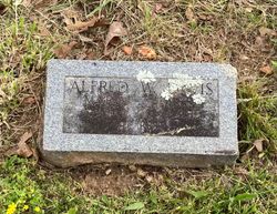
Alfred Walton Davis
| Birth | : | 17 Mar 1883 Couch, Oregon County, Missouri, USA |
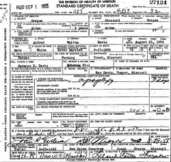
| Death | : | 23 Aug 1955 Alton, Oregon County, Missouri, USA |
| Burial | : | Tabernacle Memorial Cemetery, Barhamsville, New Kent County, USA |
| Coordinate | : | 37.4588890, -76.8005600 |
| Description | : | Son of Lorenzo Dow Davis and Mary Ann Rebecca (Hill) Davis. Never married. Farmer. Per MO Death certificate #27124, burial 25/Aug/1955. |
frequently asked questions (FAQ):
-
Where is Alfred Walton Davis's memorial?
Alfred Walton Davis's memorial is located at: Tabernacle Memorial Cemetery, Barhamsville, New Kent County, USA.
-
When did Alfred Walton Davis death?
Alfred Walton Davis death on 23 Aug 1955 in Alton, Oregon County, Missouri, USA
-
Where are the coordinates of the Alfred Walton Davis's memorial?
Latitude: 37.4588890
Longitude: -76.8005600
Family Members:
Parent

Siblings

Flowers:


Nearby Cemetories:
1. Tabernacle Memorial Cemetery
Barhamsville, New Kent County, USA
Coordinate: 37.4588890, -76.8005600
2. Mount Olive Baptist Church Cemetery
Barhamsville, New Kent County, USA
Coordinate: 37.4770830, -76.7909470
3. Sweeney Family Cemetery
Toano, James City County, USA
Coordinate: 37.4529550, -76.8415120
4. Appleton Farm Cemetery
New Kent County, USA
Coordinate: 37.4809420, -76.8375590
5. Mount Nebo Baptist Church Cemetery
Barhamsville, New Kent County, USA
Coordinate: 37.4822070, -76.8420460
6. Oliver Russell Cemetery
Eltham, New Kent County, USA
Coordinate: 37.4993100, -76.8087500
7. Saint John of Kanti Cemetery
Barhamsville, New Kent County, USA
Coordinate: 37.4881400, -76.8420300
8. Warreneye Church Cemetery
Walkers, New Kent County, USA
Coordinate: 37.5001830, -76.8494500
9. Wahrani African-American Burial Ground
Barhamsville, New Kent County, USA
Coordinate: 37.5008230, -76.8502090
10. Hrubienski Family Cemetery
Barhamsville, New Kent County, USA
Coordinate: 37.4958200, -76.8568500
11. EcoEternity Forest at Makemie Woods Cemetery
Lanexa, New Kent County, USA
Coordinate: 37.4430240, -76.8767660
12. Saint Luke's Baptist Church Cemetery
New Kent County, USA
Coordinate: 37.5200700, -76.8193130
13. Hickory Neck Church Cemetery
Toano, James City County, USA
Coordinate: 37.3934000, -76.8038000
14. First Baptist Church Cemetery
Shacklefords, King and Queen County, USA
Coordinate: 37.5072460, -76.7377920
15. Shiloh Baptist Church Cemetery
Croaker, James City County, USA
Coordinate: 37.3994500, -76.7528600
16. Pamunkey Neck Chapel Cemetery
West Point, King William County, USA
Coordinate: 37.5300962, -76.7955810
17. Angel View Baptist Church Cemetery
Lanexa, New Kent County, USA
Coordinate: 37.5023230, -76.8752810
18. Sunnyside Cemetery
James City County, USA
Coordinate: 37.3822550, -76.8212990
19. Saint Johns Baptist Church Cemetery
Toano, James City County, USA
Coordinate: 37.3813800, -76.8284000
20. Liberty Baptist Church Cemetery
Lanexa, New Kent County, USA
Coordinate: 37.4255520, -76.8952210
21. Bethany Cemetery of Our Saviours Lutheran Church
Norge, James City County, USA
Coordinate: 37.3793900, -76.7678100
22. Riverview Cemetery
Norge, James City County, USA
Coordinate: 37.3908430, -76.7385070
23. Olive Branch Christian Church Cemetery
Norge, James City County, USA
Coordinate: 37.3755000, -76.7856000
24. Richardsons Family Burial Ground
Croaker, James City County, USA
Coordinate: 37.3890000, -76.7353000