

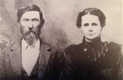
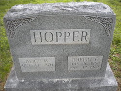
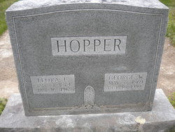
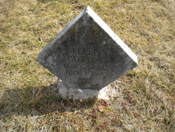
Alice Marie Cotton Hopper
| Birth | : | 17 Oct 1870 Linden, Perry County, Tennessee, USA |
| Death | : | 1955 Oklahoma, USA |
| Burial | : | Clifton Cemetery, Clifton, Oregon County, USA |
| Coordinate | : | 36.5511017, -91.5350037 |
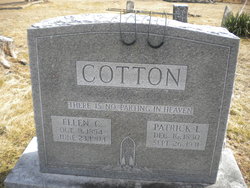
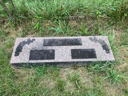
| Description | : | Daughter of Patrick L. and Ellen Cotton Married Robert Hopper in 1889 Mother of Claude Auton Hopper and twins Frances/Frankie and Georgia/Georgie Hopper Living in Thayer, Oregon, Missouri in 1910 and 1910, but in 1920 the family is living in Emporia, Lyon, Kansas. In 1930 Alice in living in Tulsa with daughter Frances Ferrell. In 1940 Alice is still in Tulsa, but now living with daughter Georgia. I am not positive she is buried here, but she does have a headstone beside her husbands and her parents are buried in this cemetery. |
frequently asked questions (FAQ):
-
Where is Alice Marie Cotton Hopper's memorial?
Alice Marie Cotton Hopper's memorial is located at: Clifton Cemetery, Clifton, Oregon County, USA.
-
When did Alice Marie Cotton Hopper death?
Alice Marie Cotton Hopper death on 1955 in Oklahoma, USA
-
Where are the coordinates of the Alice Marie Cotton Hopper's memorial?
Latitude: 36.5511017
Longitude: -91.5350037
Family Members:
Parent
Spouse
Siblings

Flowers:


Nearby Cemetories:
1. Clifton Cemetery
Clifton, Oregon County, USA
Coordinate: 36.5511017, -91.5350037
2. Old George Martin Farm Cemetery
Allen Ford, Oregon County, USA
Coordinate: 36.5374850, -91.5230010
3. Clifton Cemetery
Sloan Ford, Oregon County, USA
Coordinate: 36.5677900, -91.5329000
4. Bledsaw Cemetery
Thayer, Oregon County, USA
Coordinate: 36.5595741, -91.5537949
5. N B Allen Ford
Allen Ford, Oregon County, USA
Coordinate: 36.5411700, -91.5172900
6. Brenner Farm Cemetery
Allen Ford, Oregon County, USA
Coordinate: 36.5477000, -91.5065400
7. Ragan Cemetery
Thayer, Oregon County, USA
Coordinate: 36.5235863, -91.5213242
8. Roth Cemetery
Sloan Ford, Oregon County, USA
Coordinate: 36.5808945, -91.5498657
9. Two Mile Cemetery
Thayer, Oregon County, USA
Coordinate: 36.5485700, -91.5748800
10. Dode Jones Farm Cemetery
Sloan Ford, Oregon County, USA
Coordinate: 36.5804900, -91.5568800
11. Willard Dode Jones Farm Cemetery
Thayer, Oregon County, USA
Coordinate: 36.5808300, -91.5572300
12. Sergeant-Mount Olive Cemetery
Thayer, Oregon County, USA
Coordinate: 36.5634390, -91.5755830
13. Thayer Cemetery
Thayer, Oregon County, USA
Coordinate: 36.5152200, -91.5395100
14. Crazy Spring
Thayer, Oregon County, USA
Coordinate: 36.5818700, -91.5624100
15. Lindley Cemetery
Clifton, Oregon County, USA
Coordinate: 36.5820400, -91.5036200
16. Buehler Farm Cemetery
Clifton, Oregon County, USA
Coordinate: 36.5639496, -91.4845810
17. Warren Coats Farm Cemetery
Sloan Ford, Oregon County, USA
Coordinate: 36.5986700, -91.5438800
18. Davis Cemetery
Thayer, Oregon County, USA
Coordinate: 36.5339508, -91.4751358
19. Old Town Church of God
Old Town, Oregon County, USA
Coordinate: 36.5004900, -91.5451800
20. Spring City Cemetery
Mammoth Spring, Fulton County, USA
Coordinate: 36.4983360, -91.5308040
21. Spring City Cemetery #2
Mammoth Spring, Fulton County, USA
Coordinate: 36.4982800, -91.5299400
22. Union Hill Cemetery
Brandsville, Howell County, USA
Coordinate: 36.5256341, -91.4746829
23. Jeff Cemetery
Jeff, Oregon County, USA
Coordinate: 36.5256166, -91.4746129
24. Walker Cemetery
Thayer, Oregon County, USA
Coordinate: 36.5985985, -91.5697021