

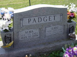
Alma Mae Eakins Padget
| Birth | : | 23 Apr 1921 Iowa, USA |
| Death | : | 10 Jul 1999 Bloomfield, Davis County, Iowa, USA |
| Burial | : | Hollywood Cemetery, Harrington, Kent County, USA |
| Coordinate | : | 38.9247017, -75.5558014 |
| Description | : | Alma married Earl Padget on 21 Apr 1938 in Lancaster, MO. PADGET Bloomfield - Mr. and Mrs. Earl Padget of Bloomfield will celebrate t heir 50th wedding anniversary with an open house from 2 to 4 p.m. Sund ay at the Bloomfield Christian Church. Earl Padget and Alma Eakins were married April 21, 1938, in Lancaster, Missouri, the Rev. Hale officiating. Hosting the event will be their children and families, Ivan and Mary Padget of Blakesburg; Norman and Doris Lindley of Villisca; Charles and Linda Ripperger of Lacona; ... Read More |
frequently asked questions (FAQ):
-
Where is Alma Mae Eakins Padget's memorial?
Alma Mae Eakins Padget's memorial is located at: Hollywood Cemetery, Harrington, Kent County, USA.
-
When did Alma Mae Eakins Padget death?
Alma Mae Eakins Padget death on 10 Jul 1999 in Bloomfield, Davis County, Iowa, USA
-
Where are the coordinates of the Alma Mae Eakins Padget's memorial?
Latitude: 38.9247017
Longitude: -75.5558014
Family Members:
Parent

Spouse
Siblings

Children
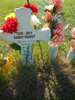
Flowers:


Nearby Cemetories:
1. Hollywood Cemetery
Harrington, Kent County, USA
Coordinate: 38.9247017, -75.5558014
2. Williamsville Cemetery
Williamsville, Kent County, USA
Coordinate: 38.8946000, -75.5130000
3. Griffiths Chapel Cemetery
Williamsville, Kent County, USA
Coordinate: 38.8958015, -75.5081024
4. Townsend Family Cemetery
Church Hill Village, Kent County, USA
Coordinate: 38.9312600, -75.4896400
5. Abbott Family Burying Ground
Felton, Kent County, USA
Coordinate: 38.9731704, -75.5796893
6. Tharp Family Cemetery
Farmington, Kent County, USA
Coordinate: 38.8736000, -75.5707000
7. Thistlewood Cemetery
Kent County, USA
Coordinate: 38.9651400, -75.5060900
8. Cordray Family Cemetery
Farmington, Kent County, USA
Coordinate: 38.8694500, -75.5688900
9. Fleming Family Cemetery
Kent County, USA
Coordinate: 38.8680100, -75.5720300
10. Benston Family Plot
Harrington, Kent County, USA
Coordinate: 38.9284470, -75.6303590
11. Anderson Family Plot
Harrington, Kent County, USA
Coordinate: 38.9017180, -75.6282340
12. Simpson Family Cemetery
Milford, Sussex County, USA
Coordinate: 38.8735200, -75.5010300
13. Whites Methodist Church Cemetery
Harrington, Kent County, USA
Coordinate: 38.9320000, -75.6549000
14. Staytonville Methodist Episcopal Church Cemetery
Sussex County, USA
Coordinate: 38.8500000, -75.5182000
15. Dawson-Griffith Family Cemetery
Staytonville, Sussex County, USA
Coordinate: 38.8455800, -75.5175000
16. Bethel Methodist Church Cemetery
Andrewsville, Kent County, USA
Coordinate: 38.8617300, -75.6368100
17. Taylor Family Plot
Andrewsville, Kent County, USA
Coordinate: 38.8540300, -75.6264880
18. Hopkins Cemetery
Felton, Kent County, USA
Coordinate: 39.0005989, -75.6211014
19. Jones Family Cemetery
Farmington, Kent County, USA
Coordinate: 38.8436000, -75.6100000
20. Parson Thorne Cemetery
Milford, Kent County, USA
Coordinate: 38.9141650, -75.4356930
21. Milford Community Cemetery New
Milford, Kent County, USA
Coordinate: 38.9256148, -75.4343761
22. Christ Episcopal Church Cemetery
Milford, Kent County, USA
Coordinate: 38.9154510, -75.4320374
23. Browns Farm Burial Ground
Brownsville, Kent County, USA
Coordinate: 38.9083000, -75.6797000
24. Methodist Episcopal Cemetery
Milford, Kent County, USA
Coordinate: 38.9162000, -75.4300000