
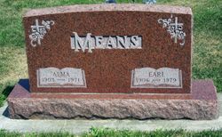
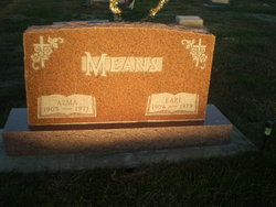
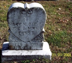
Alma Marie Ernst Means
| Birth | : | 13 Dec 1903 Mapleton, Monona County, Iowa, USA |
| Death | : | 6 Apr 1971 Sioux City, Woodbury County, Iowa, USA |
| Burial | : | South View Cemetery, Randolph, Orange County, USA |
| Coordinate | : | 43.9168200, -72.6583200 |
| Plot | : | Block 1, Lot 245 |
| Description | : | Alma Marie Means December 13, 1903 ~ April 6, 1971 Alma Marie Means, daughter of Joseph and Minnie Ernst, was born December 1 3, 1903 near Mapleton, Iowa and died Tuesday, April 6,1971 at a Sioux Ci ty hospital. She had reached the age of 67 years, 3 months, and 23 days. She was married to Earl Means December 18, 1924 at Mapleton. She and her husband were lifelong residents of the area and farmed west of Mapleton since 1943.She was a member of St. Mary's Catholic Church, The Royal Neighbors, and The Mapleton Civic Club. She... Read More |
frequently asked questions (FAQ):
-
Where is Alma Marie Ernst Means's memorial?
Alma Marie Ernst Means's memorial is located at: South View Cemetery, Randolph, Orange County, USA.
-
When did Alma Marie Ernst Means death?
Alma Marie Ernst Means death on 6 Apr 1971 in Sioux City, Woodbury County, Iowa, USA
-
Where are the coordinates of the Alma Marie Ernst Means's memorial?
Latitude: 43.9168200
Longitude: -72.6583200
Family Members:
Parent
Spouse

Siblings
Children
Flowers:


Nearby Cemetories:
1. South View Cemetery
Randolph, Orange County, USA
Coordinate: 43.9168200, -72.6583200
2. Holy Cross Cemetery
Randolph, Orange County, USA
Coordinate: 43.9163800, -72.6605200
3. Pleasant View Cemetery
Randolph, Orange County, USA
Coordinate: 43.9110600, -72.6555000
4. Moulton Cemetery
Randolph, Orange County, USA
Coordinate: 43.9267500, -72.6501200
5. Old Christ Church Cemetery
Bethel, Windsor County, USA
Coordinate: 43.8750900, -72.6475500
6. Randolph Center Cemetery
Randolph Center, Orange County, USA
Coordinate: 43.9364300, -72.6045500
7. Gilead Cemetery
Bethel, Windsor County, USA
Coordinate: 43.8730300, -72.6873300
8. Peth Cemetery
Braintree, Orange County, USA
Coordinate: 43.9656700, -72.6625100
9. Lower Branch Cemetery
Braintree, Orange County, USA
Coordinate: 43.9487100, -72.7122400
10. Vermont Veterans Memorial Cemetery
Randolph Center, Orange County, USA
Coordinate: 43.9433098, -72.5971680
11. Braintree Hill Cemetery
Braintree Hill, Orange County, USA
Coordinate: 43.9697500, -72.6881900
12. Spear Cemetery
Braintree, Orange County, USA
Coordinate: 43.9784700, -72.6839500
13. Little Hollow Cemetery
Rochester, Windsor County, USA
Coordinate: 43.8864542, -72.7384390
14. Fairview Cemetery
Bethel, Windsor County, USA
Coordinate: 43.8488998, -72.6492004
15. East Bethel Cemetery
East Bethel, Windsor County, USA
Coordinate: 43.8715500, -72.5843400
16. Brown Cemetery
Braintree, Orange County, USA
Coordinate: 43.9617600, -72.7381000
17. East Braintree Cemetery
East Braintree, Orange County, USA
Coordinate: 43.9906100, -72.6491700
18. East Randolph Cemetery
East Randolph, Orange County, USA
Coordinate: 43.9276300, -72.5532200
19. Mountain View Cemetery
West Braintree, Orange County, USA
Coordinate: 43.9670200, -72.7441500
20. Mann Cemetery
Braintree Hill, Orange County, USA
Coordinate: 43.9987246, -72.6754138
21. Connecticut Corners Cemetery
Braintree, Orange County, USA
Coordinate: 44.0005251, -72.7186343
22. Cherry Hill Cemetery
Bethel, Windsor County, USA
Coordinate: 43.8266983, -72.6166992
23. Carty Family Cemetery
Tunbridge, Orange County, USA
Coordinate: 43.8705500, -72.5407700
24. West Brookfield Cemetery
West Brookfield, Orange County, USA
Coordinate: 44.0143300, -72.6592300