
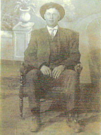
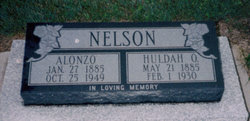
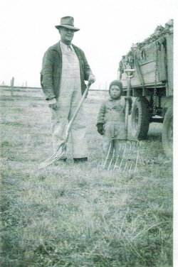


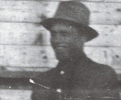
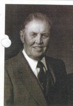
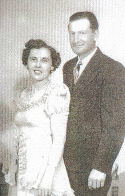
Alonzo “Lon” Nelson
| Birth | : | 25 Jan 1885 Mount Pleasant, Sanpete County, Utah, USA |
| Death | : | 25 Oct 1949 Lethbridge, Lethbridge Census Division, Alberta, Canada |
| Burial | : | Stirling Cemetery, Stirling, Lethbridge Census Division, Canada |
| Coordinate | : | 49.5093400, -112.5380000 |
| Plot | : | Lot 63 Block 7 Plot 2 |
| Description | : | Alonzo is my great grandfather. Alonzo was a farmer had had a lot of sheep & had to do sheep shering & he had a very good dog to help him with the moving of the sheep . Sunday were always gathering day at the farm with family & friends with home made ice cream . Alonzo or lon as he was called had a favoriite nephew that were very close his name was daniel babb . Dan always wanted to be with lon on the farm helping no matter how small in age he was . Lons faviorite food... Read More |
frequently asked questions (FAQ):
-
Where is Alonzo “Lon” Nelson's memorial?
Alonzo “Lon” Nelson's memorial is located at: Stirling Cemetery, Stirling, Lethbridge Census Division, Canada.
-
When did Alonzo “Lon” Nelson death?
Alonzo “Lon” Nelson death on 25 Oct 1949 in Lethbridge, Lethbridge Census Division, Alberta, Canada
-
Where are the coordinates of the Alonzo “Lon” Nelson's memorial?
Latitude: 49.5093400
Longitude: -112.5380000
Family Members:
Parent
Spouse
Siblings
Children


Nearby Cemetories:
1. Stirling Cemetery
Stirling, Lethbridge Census Division, Canada
Coordinate: 49.5093400, -112.5380000
2. Stirling Mennonite Church Cemetery
Stirling, Lethbridge Census Division, Canada
Coordinate: 49.4607570, -112.5387970
3. Temple Hill Cemetery
Raymond, Lethbridge Census Division, Canada
Coordinate: 49.4916300, -112.6605200
4. East Raymond Hutterite Colony Cemetery
Raymond, Lethbridge Census Division, Canada
Coordinate: 49.4185305, -112.5791329
5. Wolf Creek Hutterite Colony Cemetery
Stirling, Lethbridge Census Division, Canada
Coordinate: 49.4119142, -112.5163705
6. Wilson Siding Hutterite Cemetery
Wilson, Lethbridge Census Division, Canada
Coordinate: 49.6203914, -112.5781130
7. New York Hutterite Cemetery
Judson, Lethbridge Census Division, Canada
Coordinate: 49.5931870, -112.3956383
8. New Dayton Community Cemetery
New Dayton, Lethbridge Census Division, Canada
Coordinate: 49.4254300, -112.3601800
9. Lakeside Hutterite Colony Cemetery
Cranford, Lethbridge Census Division, Canada
Coordinate: 49.6685448, -112.3586315
10. Rock Lake Colony Cemetery
Coaldale, Lethbridge Census Division, Canada
Coordinate: 49.6219440, -112.2750000
11. Hutterville Hutterite Cemetery
Magrath, Claresholm Census Division, Canada
Coordinate: 49.3503165, -112.7701038
12. Coaldale Community Cemetery
Coaldale, Lethbridge Census Division, Canada
Coordinate: 49.7355600, -112.6242300
13. Coaldale Mennonite Cemetery
Coaldale, Lethbridge Census Division, Canada
Coordinate: 49.7355600, -112.6242300
14. Magrath Cemetery
Magrath, Claresholm Census Division, Canada
Coordinate: 49.3985700, -112.8648700
15. Hillridge Hutterite Colony Cemetery
Cranford, Lethbridge Census Division, Canada
Coordinate: 49.7196094, -112.3393464
16. Wrentham Cemetery
Wrentham, Lethbridge Census Division, Canada
Coordinate: 49.5231200, -112.1574800
17. Mountain View Cemetery
Lethbridge, Lethbridge Census Division, Canada
Coordinate: 49.6800385, -112.8297729
18. Rockport Colony Cemetery
Magrath, Claresholm Census Division, Canada
Coordinate: 49.3027780, -112.8136110
19. Indian Battle Park
Lethbridge, Lethbridge Census Division, Canada
Coordinate: 49.6928200, -112.8582900
20. Saint Patrick's Cemetery
Lethbridge, Lethbridge Census Division, Canada
Coordinate: 49.7084618, -112.8428726
21. Warner Memorial Cemetery
Warner, Lethbridge Census Division, Canada
Coordinate: 49.2914900, -112.2246800
22. Royal View Memorial Cemetery
Lethbridge, Lethbridge Census Division, Canada
Coordinate: 49.7518540, -112.8242250
23. Archmount Cemetery
Lethbridge, Lethbridge Census Division, Canada
Coordinate: 49.7057900, -112.9017500
24. Barnwell Cemetery
Barnwell, Lethbridge Census Division, Canada
Coordinate: 49.7691400, -112.2723800