
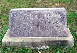

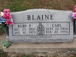
Alta Elmina Hunter Blaine
| Birth | : | 2 Feb 1878 Adams County, Iowa, USA |
| Death | : | 30 Aug 1945 Kirksville, Adair County, Missouri, USA |
| Burial | : | Riverside Cemetery, Charles City, Floyd County, USA |
| Coordinate | : | 43.0766983, -92.6881027 |
| Description | : | Daughter of James W. and Lydia Jane (Garrett) Hunter. Although Alta lived in the rural Greensburg area of Scotland County, she passed while at the Stickler Hospital in Kirksville. |
frequently asked questions (FAQ):
-
Where is Alta Elmina Hunter Blaine's memorial?
Alta Elmina Hunter Blaine's memorial is located at: Riverside Cemetery, Charles City, Floyd County, USA.
-
When did Alta Elmina Hunter Blaine death?
Alta Elmina Hunter Blaine death on 30 Aug 1945 in Kirksville, Adair County, Missouri, USA
-
Where are the coordinates of the Alta Elmina Hunter Blaine's memorial?
Latitude: 43.0766983
Longitude: -92.6881027
Family Members:
Spouse

Children
Flowers:


Nearby Cemetories:
1. Calvary Cemetery
Charles City, Floyd County, USA
Coordinate: 43.0574989, -92.6594009
2. Oakwood Cemetery
Floyd, Floyd County, USA
Coordinate: 43.1178017, -92.7307968
3. Sunnyside Memory Gardens
Charles City, Floyd County, USA
Coordinate: 43.0280991, -92.6457977
4. Meadow Of Memories Pet Cemetery
Charles City, Floyd County, USA
Coordinate: 43.1217000, -92.6147000
5. West Saint Charles United Methodist Cemetery
Floyd County, USA
Coordinate: 43.0580597, -92.7897186
6. Beckwith Cemetery
Nilesville, Floyd County, USA
Coordinate: 43.1319008, -92.6042023
7. Riverton Cemetery
Floyd County, USA
Coordinate: 42.9981003, -92.5994034
8. Howardville Cemetery
Floyd, Floyd County, USA
Coordinate: 43.1866989, -92.7016983
9. Saint Marys Catholic Cemetery
Roseville, Floyd County, USA
Coordinate: 43.0090000, -92.8134000
10. Liggett Cemetery
Charles City, Floyd County, USA
Coordinate: 42.9583100, -92.6529700
11. Flood Creek Cemetery
Floyd County, USA
Coordinate: 43.0391998, -92.8538971
12. Stillwater Cemetery
Orchard, Mitchell County, USA
Coordinate: 43.2130585, -92.6780624
13. Cedar View Cemetery
Chickasaw, Chickasaw County, USA
Coordinate: 43.0393982, -92.5064011
14. Pleasant Grove Cemetery
Powersville, Floyd County, USA
Coordinate: 42.9441986, -92.7446976
15. Mount Carroll Cemetery
Bassett, Chickasaw County, USA
Coordinate: 43.0602989, -92.4957962
16. Shannon Cemetery
Charles City, Floyd County, USA
Coordinate: 42.9366500, -92.6532000
17. Ulsterville Cemetery
Ulster Township, Floyd County, USA
Coordinate: 43.0936012, -92.8842010
18. Deerfield Mennonite Church Cemetery
Deerfield, Chickasaw County, USA
Coordinate: 43.1445100, -92.4954300
19. Orchard Cemetery
Orchard, Mitchell County, USA
Coordinate: 43.2249985, -92.7838898
20. Deerfield Cemetery
Chickasaw County, USA
Coordinate: 43.1630592, -92.4955597
21. Cagley Cemetery
Chickasaw County, USA
Coordinate: 42.9858017, -92.4957962
22. Saint Michaels Catholic Cemetery
Nashua, Chickasaw County, USA
Coordinate: 42.9556007, -92.5255966
23. Saint Boniface Cemetery
Ionia, Chickasaw County, USA
Coordinate: 43.0438995, -92.4550018
24. Pleasant Hill Cemetery
Butler County, USA
Coordinate: 42.9067001, -92.6342010