
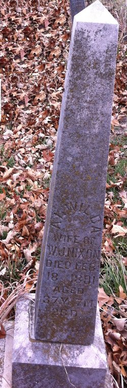
Alwilda Cook Nixon
| Birth | : | 22 Jun 1853 Indiana, USA |
| Death | : | 18 Feb 1891 Maryville, Nodaway County, Missouri, USA |
| Burial | : | Independence Hill Baptist Church Cemetery, Huntersville, Mecklenburg County, USA |
| Coordinate | : | 35.3607760, -80.8203220 |
| Plot | : | Row 5, N-S |
frequently asked questions (FAQ):
-
Where is Alwilda Cook Nixon's memorial?
Alwilda Cook Nixon's memorial is located at: Independence Hill Baptist Church Cemetery, Huntersville, Mecklenburg County, USA.
-
When did Alwilda Cook Nixon death?
Alwilda Cook Nixon death on 18 Feb 1891 in Maryville, Nodaway County, Missouri, USA
-
Where are the coordinates of the Alwilda Cook Nixon's memorial?
Latitude: 35.3607760
Longitude: -80.8203220
Family Members:
Parent
Spouse

Siblings
Children
Flowers:

Thinking of you. I am your great granddaughter. Your son Charles Henry Nixon had daughter Maud Nixon Ragsdale who in time gave birth to me and six other children.
Left by Anonymous on 10 Aug 2013

Rest in Peace
Left by Anonymous on 25 May 2016

I am one of your great great granddaughters. You are not forgotten. Rest in Peace.
Left by Anonymous on 26 Jun 2018

Left by Anonymous on 08 Aug 2019


Nearby Cemetories:
1. Independence Hill Baptist Church Cemetery
Huntersville, Mecklenburg County, USA
Coordinate: 35.3607760, -80.8203220
2. Jonahville AME Zion Church Cemetery
Mecklenburg County, USA
Coordinate: 35.3568993, -80.7975006
3. Northlake Memorial Gardens
Huntersville, Mecklenburg County, USA
Coordinate: 35.3664000, -80.8483000
4. Asbury United Methodist Church Cemetery
Huntersville, Mecklenburg County, USA
Coordinate: 35.3845000, -80.8034000
5. Chapel Hill Missionary Baptist Church Cemetery
Huntersville, Mecklenburg County, USA
Coordinate: 35.3733710, -80.8537610
6. Oak Grove United Methodist Church Cemetery
Charlotte, Mecklenburg County, USA
Coordinate: 35.3274994, -80.8253021
7. Bethel Methodist Church Cemetery
Derita, Mecklenburg County, USA
Coordinate: 35.3264200, -80.8133800
8. Holy Covenant United Church of Christ
Charlotte, Mecklenburg County, USA
Coordinate: 35.3318800, -80.7922000
9. United House of Prayer Cemetery
Huntersville, Mecklenburg County, USA
Coordinate: 35.3970110, -80.8346510
10. Huntersville AME Zion Church Cemetery
Huntersville, Mecklenburg County, USA
Coordinate: 35.4000560, -80.8378630
11. Saint Phillip Missionary Baptist Church
Huntersville, Mecklenburg County, USA
Coordinate: 35.4053320, -80.8321020
12. Huntersville Presbyterian Church Cemetery
Huntersville, Mecklenburg County, USA
Coordinate: 35.4045000, -80.8387000
13. Saint Marks Episcopal Church
Huntersville, Mecklenburg County, USA
Coordinate: 35.3477310, -80.8810810
14. McCoy Slave Cemetery
Huntersville, Mecklenburg County, USA
Coordinate: 35.3591430, -80.8837300
15. Huntersville ARP Church Cemetery
Huntersville, Mecklenburg County, USA
Coordinate: 35.4149920, -80.8415440
16. Miranda Cemetery
Charlotte, Mecklenburg County, USA
Coordinate: 35.3339690, -80.8820400
17. First Baptist Church Cemetery
Huntersville, Mecklenburg County, USA
Coordinate: 35.4151000, -80.8447000
18. New Friendship Presbyterian Church Cemetery
Huntersville, Mecklenburg County, USA
Coordinate: 35.4205140, -80.8413330
19. Hopewell Presbyterian Church Cemetery
Huntersville, Mecklenburg County, USA
Coordinate: 35.3662500, -80.8984000
20. Mallard Creek Presbyterian Church Cemetery
Charlotte, Mecklenburg County, USA
Coordinate: 35.3344994, -80.7485962
21. Mallard Creek Presbyterian Church Slave Cemetery
Charlotte, Mecklenburg County, USA
Coordinate: 35.3347500, -80.7481000
22. Ava Parks cemetery
Huntersville, Mecklenburg County, USA
Coordinate: 35.3632100, -80.9001200
23. Pleasant Grove A.M.E. Zion Church Cemetery
Mecklenburg County, USA
Coordinate: 35.3833533, -80.7426050
24. Derita Presbyterian Church Columbarium
Charlotte, Mecklenburg County, USA
Coordinate: 35.2941090, -80.7958710